Related Research Articles
John Heckman was a political figure in Nova Scotia. He represented Lunenburg County from 1818 to 1826 and Luneng burg township from 1826 to 1847 in the Nova Scotia House of Assembly.
Green Bay is a community in the Canadian province of Nova Scotia, located in the Lunenburg Municipal District in Lunenburg County.
Chelsea is a community in the Canadian province of Nova Scotia, located in the Lunenburg Municipal District in Lunenburg County, Nova Scotia. It was probably named for Chelsea, London.
Newcombville is a community in the Canadian province of Nova Scotia, located in the Lunenburg Municipal District in Lunenburg County 11 kilometers or seven miles from Bridgewater-the county service center on the shores of the LaHave River.
Blockhouse is a community in the Canadian province of Nova Scotia, located in the Lunenburg Municipal District in Lunenburg County. It was named after the blockhouses constructed by Captain Ephraim Cook to protect colonists following a raid in 1756. The final blockhouse in the community burned down in 1874.
Hebb's Cross is a community in the Canadian province of Nova Scotia, located in the Municipality of the District of Lunenburg in Lunenburg County on Highway 103 about seven miles south-southwest of Bridgewater, between Hebbville and Italy Cross.
Nineveh is a community in the Canadian province of Nova Scotia, located in the Lunenburg Municipal District in Lunenburg County. It was named for the ancient city of Nineveh.
Simpson's Corner is a community in the Canadian province of Nova Scotia, located in the Lunenburg Municipal District in Lunenburg County.
Cookville is a community in the Canadian province of Nova Scotia, located in the Lunenburg Municipal District in Lunenburg County.
West Northfield is a community in the Canadian province of Nova Scotia, located in the Lunenburg Municipal District in Lunenburg County. It lies in a drumlinized area along the LaHave River. The loam-textured podzolic soils tend to be strongly acidic and stony. However, favorable drainage and moisture-holding capacity make them suitable for agriculture and forestry. A Christmas tree industry has developed around the community in recent years.
Pentz is a rural community in the Canadian province of Nova Scotia, located in the Lunenburg Municipal District in Lunenburg County.
Blue Rocks is a community in the Canadian province of Nova Scotia, located in the Lunenburg Municipal District in Lunenburg County. It stands to seaward of Lunenburg, Nova Scotia, somewhat to the east. For many years a fishing village, it was discovered by many artists and photographers beginning in the 1940s. Today the village boasts many artists, and there are also numerous guest houses to be found among the fishermen's dwellings.
Herman's Island is a community in the Canadian province of Nova Scotia, located in the Lunenburg Municipal District in Lunenburg County.
Lake William is a community in the Canadian province of Nova Scotia, located in the Lunenburg Municipal District in Lunenburg County.
Second Peninsula is a community in the Canadian province of Nova Scotia, located in the Lunenburg Municipal District in Lunenburg County.
Stonehurst is a community in the Canadian province of Nova Scotia, located in the Lunenburg Municipal District in Lunenburg County.

The Raid on Lunenburg occurred during the French and Indian War when Mi'kmaq and Maliseet fighters attacked a British settlement at Lunenburg, Nova Scotia on May 8, 1756. The native militia raided two islands on the northern outskirts of the fortified Township of Lunenburg, Rous Island, and Payzant Island. According to French reports, the Raiding party killed twenty settlers and took five prisoners. This raid was the first of nine the Natives and Acadians would conduct against the peninsula over a three-year period during the war. The Wabanaki Confederacy took John Payzant and Lewis Payzant prisoner, both of whom left written account of their experiences.
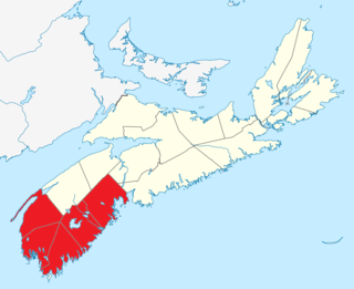
Southern Nova Scotia or the South Shore is a region of Nova Scotia, Canada. The area has no formal identity and is variously defined by geographic, county and other political boundaries. Statistics Canada, defines Southern Nova Scotia as an economic region, composed of Lunenburg County, Queens County, Shelburne County, Yarmouth County, and Digby County. According to Statistics Canada, the region had the highest decrease of population in Canada from 2009 to 2010, with a population decrease of 10.2 residents per thousand. The region also has the second-highest median age in Canada at 47.1 years old.
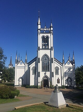
St. John's Anglican Church was the first church established in Lunenburg, Nova Scotia, Canada (1753). It is the second Church of England built in Nova Scotia, and is the second oldest continuous Protestant church in present-day Canada. Early on 1 November 2001, St. John's church suffered significant damage by fire. It was restored and re-dedicated June 12, 2005.

A township in Nova Scotia, Canada, was an early form of land division and local administration during British colonial settlement in the 18th century. They were created as a means of populating the colony with people loyal to British rule. They were typically rural or wilderness areas of around 100,000 acres (400 km2) that would eventually include several villages or towns. Some townships, but not all, returned a member to the General Assembly of Nova Scotia; others were represented by the members from the county. Townships became obsolete by 1879 by which time towns and counties had become incorporated.