Jondal is a municipality in Hordaland county, Norway. It is located on the Folgefonna peninsula in the Hardanger district, on the eastern shore of the Hardangerfjorden. The administrative centre of the municipality is the village of Jondal. Other villages in Jondal include Herand, Kysnesstranda, and Torsnes.

Meldal is a municipality in Trøndelag county, Norway. It is part of the Orkdalen region. The administrative centre of the municipality is the village of Meldal. Other villages include Løkken Verk, Bjørnli, Å, and Storås.

Målselv is a municipality in Troms county, Norway. The administrative centre of the municipality is the village of Moen. The main commercial centre of the municipality is the Bardufoss area. Other villages in the municipality include Alappmoen, Fossmoen, Holmen, and Skjold. Besides bordering Sweden to the east and the ocean to the northwest, it borders the municipalities of Balsfjord, Storfjord, Bardu, Sørreisa, and Lenvik.

Bardufoss is an urban area and commercial centre in Målselv Municipality in Troms county, Norway. The three villages of Andselv, Andslimoen, and Heggelia together form the Bardufoss area. Bardufoss is located in the Målselvdalen valley near the confluence of the Barduelva and Målselva rivers. It is located about 82 kilometres (51 mi) north of the town of Narvik and about 70 kilometres (43 mi) south of the city of Tromsø. Bardufoss Airport is located here. The 2.96-square-kilometre (730-acre) urban area has a population (2017) of 2,545 which gives it a population density of 860 inhabitants per square kilometre (2,200/sq mi).

Nordkjosbotn (Norwegian) or Gárgán (Northern Sami) is a small village in Balsfjord Municipality in Troms county, Norway. The village lies about 70 kilometres (43 mi) southeast of the city of Tromsø. Two major highways, European route E6 and European route E8, meet in this village, making it a major crossroads in Northern Norway, with an estimated annual passage of 3 million people. The 0.7-square-kilometre (170-acre) village has a population (2017) of 464 which gives the village a population density of 663 inhabitants per square kilometre (1,720/sq mi). Nordkjosbotn Church is located in this village. Macks Ølbryggeri, a brewery, has been operating in Nordkjosbotn since 2012.

Sandane is the administrative centre of the municipality of Gloppen in Sogn og Fjordane county, Norway. It is located at the end of the Gloppefjorden, along the European route E39 highway. Sandane is 20 kilometres (12 mi) south of the village of Nordfjordeid and about 16 kilometres (9.9 mi) west of the village of Byrkjelo. Sandane Airport, Anda is located 10 kilometres (6.2 mi) northwest of Sandane along highway E39. Sandane has several suburban areas that surround the nearby fjord such as Sørstranda to the west and Vereide to the northwest.

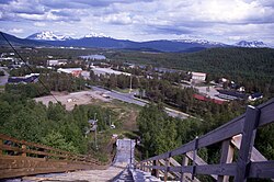
Moen is the administrative centre of Målselv Municipality in Troms county, Norway. The village of Moen is located in the Målselvdalen valley about 10 km (6.2 mi) north of the village of Andselv and Bardufoss Airport. The 0.89-square-kilometre (220-acre) village has a population (2017) of 847 which gives the village a population density of 952 inhabitants per square kilometre (2,470/sq mi).
Kasfjord is a village in Harstad Municipality in Troms county, Norway. The village is located at the end of the Kasfjorden on the north side of Hinnøya island, about 10 kilometres (6.2 mi) west of the town of Harstad and about 12 kilometres (7.5 mi) south of the village of Elgsnes. The Kasfjordvannet lake is located along the east side of the village. The 0.34-square-kilometre (84-acre) village has a population (2011) of 252. The population density is 741 inhabitants per square kilometre (1,920/sq mi).

Evenskjer is the administrative centre of Skånland Municipality in Troms county, Norway. The village is located along the Tjeldsundet strait about 25 km (16 mi) south of the town of Harstad. European route E10 passes just to the north of the village of Evenskjer. The 0.81-square-kilometre (200-acre) village has a population (2017) of 785 which gives the village a population density of 969 inhabitants per square kilometre (2,510/sq mi).

Setermoen is the administrative centre of Bardu Municipality in Troms county, Norway. The village is located along the Barduelva river, about 25 kilometres (16 mi) east of the village of Sjøvegan and about 25 kilometres (16 mi) south of Bardufoss.
Andslimoen is a village in Målselv Municipality in Troms county, Norway. The village, which lies along the river Målselva in the Målselvdalen valley in the western part of the municipality, is part of the urban area known as Bardufoss. The village is located along European route E6 highway, about 3.5 km (2.2 mi) north of the village of Andselv and about 5.5 km (3.4 mi) south of the village of Moen. The 0.74-square-kilometre (180-acre) village has a population (2017) of 545 which gives the village a population density of 736 inhabitants per square kilometre (1,910/sq mi).
Andselv is a village in Målselv Municipality in Troms county, Norway. The village lies along the Andselva river in the urban area called Bardufoss. Andselv is located just north of Bardufoss Airport along the European route E6 highway about 2 km (1.2 mi) north of the village of Heggelia and 3.5 km (2.2 mi) south of the village of Andslimoen.
Senjahopen or Senjehopen is a village in the municipality of Berg in Troms county, Norway. Senjahopen is located along the Mefjorden on the northwest part of the large island of Senja, where it is one of the most important fishing villages on the island. Another nearby fishing village is Mefjordvær, which located about 3 kilometres (1.9 mi) to the northwest.

Movik is a village in Tromsø Municipality in Troms county, Norway. It is located along the Tromsøysundet strait on the mainland part of the municipality. The village sits about 10 kilometres (6.2 mi) northeast of the city of Tromsø and about 3.3 kilometres (2.1 mi) north of the village of Kroken. The 0.21-square-kilometre (52-acre) village has a population (2017) of 381 which gives the village a population density of 1,814 inhabitants per square kilometre (4,700/sq mi).

Brandsøy (Brandsoy) is a village in the municipality of Flora in Sogn og Fjordane county, Norway. It is located on both sides of small strait that separates the east end of the island of Brandsøya and the mainland. The village sits along the Norwegian National Road 5 highway, about 6.9 kilometres (4.3 mi) east of the town of Florø and about 10 kilometres (6.2 mi) west of the village of Grov. The 0.4-square-kilometre (99-acre) village has a population (2013) of 420, giving the village a population density of 1,337 inhabitants per square kilometre (3,460/sq mi).

Sande is the administrative centre of the municipality of Gaular in Sogn og Fjordane county, Norway. The village is located along the Gaula River, about 10 kilometres (6.2 mi) from where the river meets the Dalsfjorden. The 0.59-square-kilometre (150-acre) village has a population (2013) of 745, giving the village a population density of 1,263 inhabitants per square kilometre (3,270/sq mi). Sande Church is located in this village, serving the people of the central part of the municipality.

The Målselva is a river in Målselv Municipality in Troms county, Norway. The 140-kilometre (87 mi) long river flows through the Målselvdalen valley and then empties into the Målselvfjorden, an arm of the Malangen fjord. The municipality and the valley through which the river runs are both named after the river.

Søfteland or Syfteland is a village in Os municipality in Hordaland county, Norway. It lies on the Bergen Peninsula, along the European route E39 highway, about 6 kilometres (3.7 mi) north of the municipal centre of Osøyro and about 20 kilometres (12 mi) south of the city of Bergen. The mountain Møsnuken lies about 3.5 kilometres (2.2 mi) east of the village and the mountain Lyshornet lies about 2.3 kilometres (1.4 mi) west of the village. The 0.94-square-kilometre (230-acre) village has a population (2013) of 1425, giving the village a population density of 1,516 inhabitants per square kilometre (3,930/sq mi).
Vennesla is the administrative centre of Vennesla municipality in Vest-Agder county, Norway. The village is located in the upper Torridal valley along the river Otra, about 15 kilometres (9.3 mi) north of the city of Kristiansand. The village itself extends for about 10 kilometres (6.2 mi) along both sides of the river. The Norwegian National Road 9 passes through Mosby, about 6 kilometres (3.7 mi) south of Vennesla. The Sørlandsbanen railway line passes through Vennesla, stopping at Vennesla Station. The lake Venneslafjorden is located on the river Otra in the northern part of the village of Vennesla.

Åmli is the administrative centre of Åmli municipality in Aust-Agder county, Norway. The village is located along the Norwegian National Road 41 and the river Nidelva, about 30 kilometres (19 mi) northwest of the town of Tvedestrand via the Norwegian County Road 415. The village of Nelaug lies about 15 kilometres (9.3 mi) to the southeast and the village of Dølemo lies about 10 kilometres (6.2 mi) to the southwest. The 0.8-square-kilometre (200-acre) village has a population (2017) of 682 which gives the village a population density of 853 inhabitants per square kilometre (2,210/sq mi).