Related Research Articles

Smith Island is 20 miles (32 km) long and 5 miles wide, lying 49 miles (79 km) west of Deception Island in the South Shetland Islands of the British Antarctic Territory. It is separated from Snow Island by the 25 miles (40 km)-wide Boyd Strait, and from Low Island by the 17 miles (27 km)-wide Osmar Strait. Surface area is 148 square kilometres (57 sq mi).

Ezcurra Inlet is an inlet forming the western arm of Admiralty Bay, King George Island, in the South Shetland Islands. It was charted by the French Antarctic Expedition, 1908–10, under Jean-Baptiste Charcot, and named "Fiord Ezcurra" after Pedro de Ezcurra, an Argentine politician and Minister of Agriculture in 1908, who assisted the French expedition.
Ajax Icefall' is an icefall between Stenhouse Bluff and Ullmann Spur at the head of Visca Anchorage, King George Island, in the South Shetland Islands. Charted by the French Antarctic Expedition under Jean-Baptiste Charcot in 1908–10. Named by the United Kingdom Antarctic Place-Names Committee in 1960 for HMS Ajax, which assisted in the search for a boat crew from the Discovery II, missing on King George Island in January 1937.

False Bay is a bay 4 miles (6.4 km) long, which lies between Barnard Point and Miers Bluff on the south side of Livingston Island, in the South Shetland Islands, Antarctica. The glaciers Hurd Ice Cap, Huntress, Ruen Icefall, Peshtera and Charity feed the bay.

Morton Strait is the 9 km (4.9 nmi)-long and 6.2 km (3.3 nmi)-wide strait between Snow Island on the southwest and Rugged Island and Livingston Island on the northeast, in the South Shetland Islands, Antarctica. The Aim Rocks and Long Rock lie in the strait.
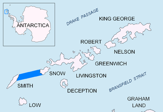
Boyd Strait is the 40-kilometre (25 mi) wide strait lying between Snow Island and Smith Island in the South Shetland Islands, Antarctica, and linking Drake Passage and the Bransfield Strait.

Caraquet Rock is a rock lying nearly 4 nautical miles (7 km) west-southwest of Bell Point, off the west part of King George Island in the South Shetland Islands. It was named by the UK Antarctic Place-Names Committee in 1960 for the sealing vessel Caraquet from Liverpool, which visited the South Shetland Islands in 1821–22.

Kraków Dome is the ice dome covering Kraków Peninsula, King George Island, in the South Shetland Islands. The name Kopula Krakowa, after Kraków, the old capital of Poland, was applied to this feature by the Polish Antarctic Expedition, 1980.
Trowbridge Island is an island lying 2 nautical miles (3.7 km) northwest of Cape Melville in Destruction Bay, off the east coast of King George Island in the South Shetland Islands. Named by the United Kingdom Antarctic Place-Names Committee (UK-APC) in 1960 for the sealer Lady Trowbridge from Liverpool, which was wrecked off Cape Melville on December 25, 1820.
The Emerald Icefalls are icefalls along the north side of Ezcurra Inlet, Admiralty Bay, King George Island, in the South Shetland Islands. They were so named by the Polish Antarctic Expedition, 1980, from the color of the serac.
Moby Dick Icefall is an icefall at the head of Destruction Bay, in the east of King George Island, in the South Shetland Islands. It was named by the Polish Antarctic Expedition of 1981 after the famous white whale of Herman Melville's 1851 novel Moby-Dick.

Cape Garry is a cape forming the south-western extremity of Low Island in the South Shetland Islands of Antarctica. It was charted and named by a British expedition under Henry Foster, 1828–31, and was more accurately mapped by the Falkland Islands Dependencies Survey in 1959 from aerial photographs taken by the Falkland Islands and Dependencies Aerial Survey Expedition, 1955–57.
Goulden Cove is the southern of two coves at the head of Ezcurra Inlet, Admiralty Bay, on King George Island, in the South Shetland Islands. It was probably named by the French Antarctic Expedition under Jean-Baptiste Charcot, who surveyed Admiralty Bay in December 1909. Located at its head is an icefall called Doctors Icefall.
Livonia Rock is a rock lying 0.5 nautical miles (1 km) south of Cape Melville, the eastern extremity of King George Island, in the South Shetland Islands, Antarctica. It was named by the UK Antarctic Place-Names Committee in 1960 for the sealing vessel Livonia from London, which visited the South Shetland Islands in 1821–22.
Hauken Rock is a rock lying nearly 1 nautical mile (2 km) east of the Ornen Rocks and 2 nautical miles (4 km) northeast of Cape Melville, the eastern extremity of King George Island, in the South Shetland Islands. It was named by the UK Antarctic Place-Names Committee in 1960 from association with Ornen Rocks. Hauken and Ørnen, the first two modern whale catchers, accompanied the floating factory ship Admiralen to the South Shetland Islands in January–February 1906.
Starshot Glacier is a glacier 50 nautical miles (90 km) long that flows through the Churchill Mountains to enter the Ross Ice Shelf in Antarctica.
Legru Bay is a bay 2 nautical miles (4 km) wide, indenting the south coast of King George Island, South Shetland Islands, Antarctica, immediately northeast of Martins Head. The French Antarctic Expedition, 1908–10, under Jean-Baptiste Charcot applied the name "Cap Legru" to a feature which has now been identified as Martins Head. As the latter has priority, Charcot's name has been transferred to this bay in order to retain the name in the area in which it was originally given.

Whalers Bay is a small bay entered between Fildes Point and Penfold Point at the east side of Port Foster, Deception Island, in the South Shetland Islands of Antarctica. The bay was so named by the French Antarctic Expedition, 1908–10, under Charcot, because of its use at that time by whalers.
Ronald Hill is a rocky, ice-free hill, 105 m in height, standing north of Kroner Lake on Deception Island, in the South Shetland Islands of Antarctica. It was charted, photographed and named by Olaf Holtedahl of the Norwegian expedition 1927–28, after the floating factory SS Ronald, which belonged to the Hektor Whaling Company. and was anchored at Deception Island in 1911-12 and many later seasons.
The Forbidden Plateau is a long, narrow plateau extending southwestward from Charlotte Bay to Flandres Bay in Graham Land. It borders Bruce Plateau on the south and Foster Plateau on the north. The feature was mapped by the Falkland Islands Dependencies Survey (FIDS) from photos taken by Hunting Aerosurveys Ltd. in 1956–57. Its name was picked by the UK Antarctic Place-names Committee (UK-APC) because all attempts to reach the plateau failed until it was finally traversed by Falkland Islands Dependencies Survey (FIDS) members in 1957.
References
- ↑ "Hektor Icefall". Geographic Names Information System . United States Geological Survey, United States Department of the Interior . Retrieved 2012-06-09.
![]() This article incorporates public domain material from "Hektor Icefall". Geographic Names Information System . United States Geological Survey.
This article incorporates public domain material from "Hektor Icefall". Geographic Names Information System . United States Geological Survey.
| | This King George Island (South Shetland Islands) location article is a stub. You can help Wikipedia by expanding it. |