Heldburger Gangschar

Last updated

The Heldburger Gangschar is a Cenozoic volcanic system in the Franconian parts of southern Thuringia and northern Bavaria. The term Gangschar refers to the fact that few of the volcanoes have retained their characteristic topographical shape, rather their former activity can be detected by filled fissures known as Gänge ("[mineral] veins"). These veins are mostly oriented in south-southwest direction, their cross-section is often less than one metre wide. The Heldburger Gangschar' is named after the small settlement of Heldburg, part of the borough of Bad Colberg-Heldburg. The surrounding area, the Heldburger Land, belongs entirely to the northern part of the volcanic zone. The most impressive of the surviving volcanic cones by far are the twin peaks of the Gleichberge, 641 metres and 679 metres high, in nearby Heldburger Land.

The Cenozoic Era meaning "new life", is the current and most recent of the three Phanerozoic geological eras, following the Mesozoic Era and extending from 66 million years ago to the present day.

Volcanic field Area of the Earths crust prone to localized volcanic activity

A volcanic field is an area of the Earth's crust that is prone to localized volcanic activity. They usually contain 10 to 100 volcanoes such as cinder cones and are usually in clusters. Lava flows may also occur. They may occur as a monogenetic volcanic field or a polygenetic volcanic field.

Franconia Cultural region of Germany

Franconia is a region in southern Germany, characterised by its culture and language, and may be roughly associated with the areas in which the East Franconian dialect group, colloquially referred to as "Franconian", is spoken. Because of this, the region can be roughly associated with the three administrative regions of Lower, Middle, and Upper Franconia in the state of Bavaria. Also part of the cultural region of Franconia are the adjacent Franconian-speaking region of South Thuringia, as well as Heilbronn-Franconia in the state of Baden-Württemberg, and small parts of the state of Hesse.

Contents

Location

The high rocky mountains of the Gleichberge (679 m and 641 m) in nearby Heldburger Land Gleichberge vom Simmersberg aus.jpg
The high rocky mountains of the Gleichberge (679 m and 641 m) in nearby Heldburger Land
Heldburg Fortress in Heldburger Land on the 405-metre-high, hill made of phonolite Veste heldburg.jpg
Heldburg Fortress in Heldburger Land on the 405-metre-high, hill made of phonolite
The 449-metre-high hill of Straufhain with the ruins of the medieval Straufhain Castle at its summit Straufhain bei Streufdorf.jpg
The 449-metre-high hill of Straufhain with the ruins of the medieval Straufhain Castle at its summit

The Heldburger Gangschar is not a self-contained landscape and is distributed mainly over the main physiographic units Grabfeld, Itz-Baunach Hill Country and Haßberge Hills. South of the river Main their former activity is also detectable in the northern Steigerwald and Franconian Jura. Its core zone extends from Hildburghausen to Gerolzhofen.

Grabfeld

The Grabfeld is a region in Germany, on the border between Bavaria and Thuringia. It is situated southeast of the Rhön Mountains. Its highest elevation is 679 metres high in the little Gleichberge mountain range. The Grabfeld gave its name to the Bavarian district of Rhön-Grabfeld and the Thuringian municipality of Grabfeld.

Haßberge Hills mountain range

The Haßberge are a hill range, up to 512.2 m above sea level (NN), north of the River Main in Lower Franconia in the German state of Bavaria. The hills are in the county of Bamberg and divided by the Main valley from their sister hills, the Steigerwald. Both forested hill ranges fall steeply down to the Main. Between the Ebelsbach and Haßfurt the river cuts through the hills in a wide gap, creating an easy route between the Upper Main and the fertile Middle Main region.

Main (river) right tributary of Rhine river in Germany

The Main is a river in Germany. With a length of 525 kilometres (326 mi), it is the longest right tributary of the Rhine. It is also the longest river lying entirely in Germany. The largest cities along the Main are Frankfurt am Main and Würzburg.

Volcanic cones

The following are the best known, preserved volcanic cones, together with details of their height, approximate age and rock in brackets:

Großer Gleichberg mountain in Thuringia, Germany

At 679 m above sea level (NHN), the Großer Gleichberg is the higher of the two adjacent mountaintops known as the Gleichberge east of Römhild in the landscape of Grabfeld and the county of Hildburghausen in the German state of Thuringia. It was formed in the Tertiary volcanic field of the Heldburger Gangschar and is the highest point today of that formation.

Kleiner Gleichberg mountain in Germany

The Kleiner Gleichberg is the slightly lower of the two Gleichberge mountains, east of the village of Römhild in the country of Grabfeld in the county of Hildburghausen in the German state of Thuringia. The Celtic Oppidum Steinsburg is located on the mountain.

Straufhain Place in Thuringia, Germany

Straufhain is a municipality in the Hildburghausen district of Thuringia, Germany.

Older volcanoes such as the Oberleinleiter in the Franconian Jura (31 million years old, olivine-melilite-nephelinite and olivine-nephelinite) are no longer recognizable as such by their topography. Although the latter reaches a height of 505 metres, it is overshadowed by the Jurassic rocks of the Alps.

Literature

International Standard Book Number Unique numeric book identifier

The International Standard Book Number (ISBN) is a numeric commercial book identifier which is intended to be unique. Publishers purchase ISBNs from an affiliate of the International ISBN Agency.

Related Research Articles

Antofagasta de la Sierra mountain in Argentina

Antofagasta de la Sierra is a volcanic field in Argentina. The main type of volcanic edifice in the area are scoria cones, it is formed by the La Laguna, Jote and Alumbrera volcanoes. The first and last of these form a sub-group which is better researched. Various dating methods have yielded ages from several million to several hundred thousand years ago, but some vents appear to be of Holocene age.

Baunach Place in Bavaria, Germany

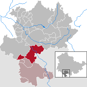
Baunach is a town in the Upper Franconian district of Bamberg and the seat of the administrative community (Verwaltungsgemeinschaft) of Baunach. Until administrative reform in 1972, Baunach belonged to the Lower Franconian district of Ebern.

Ampato dormant Peruvian volcano

Ampato is a dormant 6,288-metre (20,630 ft) stratovolcano in the Andes of southern Peru. It lies about 70–75 kilometres (43–47 mi) northwest of Arequipa and is part of a north-south chain that includes the volcanoes Hualca Hualca and Sabancaya, the last of which has been active in historical time.

Puyuhuapi Volcanic Group is a volcanic group of cinder cones located at the head of Puyuhuapi Channel, in the Aysén del General Carlos Ibáñez del Campo Region of Chile.

The Bridge River Cones, sometimes referred to as the Lillooet Cones and Salal Creek Cones, is the name given to a volcanic field located on the north flank of the upper Bridge River, about 40 km (25 mi) west of the town of Gold Bridge. The cones are in the lee of the Lillooet Icecap and sit astride a group of passes between the Bridge River, which flows W-E to their south, and the Lord River, which flows north to the Taseko Lakes in the Chilcotin District.

West Crater

West Crater is a small lava dome with associated lava flows in southern Washington, United States. Located in Skamania County, it rises to an elevation of 4,131 feet (1,259 m), and forms part of the Cascade Volcanic Arc. It is also part of the Marble Mountain-Trout Creek Hill volcanic field, a little-known Quaternary volcanic field in the southern Cascades of Washington state. The area can be hiked, and can be accessed by roads in the Gifford Pinchot National Forest.

San Pedro (Chile volcano) one of the tallest active volcanoes in the world

San Pedro is a Holocene composite volcano in northern Chile and one of the tallest active volcanoes in the world. Part of the Chilean Andes' volcanic segment, it is part of the Central Volcanic Zone of the Andes, one of the four tracts of the Andean Volcanic Belt. This region of volcanism includes the world's two highest volcanoes Ojos del Salado and Llullaillaco. San Pedro, like other Andean volcanoes, was formed by the subduction of the Nazca Plate beneath the South America Plate. It has a neighbouring volcano, San Pablo, and is itself formed by two separate edifices usually known as the Old Cone and the Young Cone. These edifices are formed by rocks ranging from basaltic andesite over andesite to dacite and are emplaced on a basement formed by Miocene volcanic rocks.

Nevado San Francisco mountain in Argentina

Nevado San Francisco, or Cerro San Francisco, is a stratovolcano on the border between Argentina and Chile, located just southeast of San Francisco Pass. It is considered extinct and is one of the several 6,000 m (19,700 ft) peaks in the area, of which the chief is the Ojos del Salado.

Volcanic history of the Northern Cordilleran Volcanic Province

The volcanic history of the Northern Cordilleran Volcanic Province presents a record of volcanic activity in northwestern British Columbia, central Yukon and the U.S. state of easternmost Alaska. The volcanic activity lies in the northern part of the Western Cordillera of the Pacific Northwest region of North America. Extensional cracking of the North American Plate in this part of North America has existed for millions of years. Continuation of this continental rifting has fed scores of volcanoes throughout the Northern Cordilleran Volcanic Province over at least the past 20 million years and occasionally continued into geologically recent times.

Zeilberg mountain

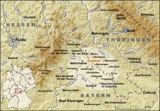
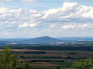
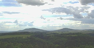
The Zeilberg is a hill, 463 m above NHN, in the Haßberge Nature Park and county of Haßberge in eastern Lower Franconia, about 2 kilometres (1.2 mi) east of Maroldsweisach. It is one of the few still recognisable volcanoes of the Heldburger Gangschar and gives its name to the Zeilberge, which are the highest part of the Itz-Baunach Hills that are geologically part of the actual Haßberge to the west, but are separated from them by the Baunach valley.

Ash Hill, New Zealand mountain

Ash Hill is a volcano in Wiri, in the Auckland volcanic field. A low tuff cone with an explosion crater about 150m wide, it is now covered by industrial development. It peaked at roughly 30 metres above sea level.

The Franconian Keuper-Lias Plains or Franconian Keuper-Lias Lands are a major natural region in the South German Scarplands in Upper Franconia and to a lesser extent in the north, in the Thuringian district of Hildburghausen. As the name betrays, the term embraces both the Keuper landscapes and lias landscapes in Franconia. In addition, the foreland of the Franconian Jura, in which part of the Brown Jurassic occurs, as well as parts of the former volcanic region of Heldburger Gangschar belong to this region.

Heldburger Land

The Heldburger Land was the historical, Saxon, administrative district (Amtsbezirk) of Heldburg and is today the southernmost part of the Free State of Thuringia and the district of Hildburghausen, between the towns of Coburg, Hildburghausen and Bad Königshofen. The region known now as the Heldburger Land is referred to administratively as the Heldburger Unterland, and sometimes in the vernacular as the Heldburger Zipfel.

Heldburg Fortress

Heldburg Fortress is a high medieval hilltop castle in the 16th Century was rebuilt into a renaissance castle. It rises on a former volcanic region to 'Heldburger Gangschar' counted, 405-metre-high volcanic cone, 113 metres above the town of Heldburg in the Heldburger Land, the southern tip of the district Hildburghausen in Thuringia. The Veste Heldburg, once a secondary residence and hunting lodge of the Dukes of Coburg, dominates the little town of Heldburg on the Thuringian border with Bavaria. From it can be seen across the Thuringian border the sister-castle Veste Coburg,, once the residence of the Dukes of Coburg, now located in Bavaria.

Gleichberge German mountain range

The Gleichberge, which mainly comprise the Großer and Kleiner Gleichberg, are a small, inselberg-like mountain range, up to 679 m above sea level (NHN), in the southwestern part of the German state of Thuringia. They rise just east of the little ancient town of Römhild in the county of Hildburghausen.

Pali-Aike volcanic field Volcanic Field of Chile and Argentina

Pali-Aike volcanic field is a volcanic field in Argentina which straddles the border with Chile. It is part of a province of back-arc volcanoes in Patagonia, which formed from processes involving the collision of the Chile Rise with the Peru–Chile Trench. It lies farther east than the Austral Volcanic Zone, the volcanic arc which forms the Andean Volcanic Belt at this latitude.

References

Coordinates: 50°17′19″N10°43′43″E / 50.2886°N 10.7286°E / 50.2886; 10.7286

Geographic coordinate system Coordinate system

A geographic coordinate system is a coordinate system that enables every location on Earth to be specified by a set of numbers, letters or symbols. The coordinates are often chosen such that one of the numbers represents a vertical position and two or three of the numbers represent a horizontal position; alternatively, a geographic position may be expressed in a combined three-dimensional Cartesian vector. A common choice of coordinates is latitude, longitude and elevation. To specify a location on a plane requires a map projection.