
A valley is a low area between hills or mountains typically with a river running through it. In geology, a valley or dale is a depression that is longer than it is wide. The terms U-shaped and V-shaped are descriptive terms of geography to characterize the form of valleys. Most valleys belong to one of these two main types or a mixture of them, at least with respect to the cross section of the slopes or hillsides.

Geologically, a fjord or fiord is a long, narrow inlet with steep sides or cliffs, created by a glacier. There are many fjords on the coasts of Alaska, Antarctica, British Columbia, Chile, Greenland, the Faroe Islands, Iceland, Kamchatka, the Kerguelen Islands, New Zealand, Norway, Novaya Zemlya, Labrador, Nunavut, Newfoundland, Quebec, Scotland, South Georgia Island, and Washington state. Norway's coastline is estimated at 29,000 kilometres (18,000 mi) with nearly 1,200 fjords, but only 2,500 kilometres (1,600 mi) when fjords are excluded.

The Battle of Stamford Bridge took place at the village of Stamford Bridge, East Riding of Yorkshire, in England on 25 September 1066, between an English army under King Harold Godwinson and an invading Norwegian force led by King Harald Hardrada and the English king's brother Tostig Godwinson. After a bloody battle, both Hardrada and Tostig along with most of the Norwegians were killed. Although Harold Godwinson repelled the Norwegian invaders, his army was defeated by the Normans at Hastings less than three weeks later. The battle has traditionally been presented as symbolising the end of the Viking Age, although major Scandinavian campaigns in Britain and Ireland occurred in the following decades, such as those of King Sweyn Estrithson of Denmark in 1069–1070 and King Magnus Barefoot of Norway in 1098 and 1102–1103.

Aust-Agder is one of 18 counties (fylker) in Norway, bordering Telemark, Rogaland, and Vest-Agder counties. In 2002, there were 102,945 inhabitants, which is 2.2% of the total population in Norway. Its area is 9,212 square kilometres (3,557 sq mi). The administrative center of the county is the town of Arendal.

Oppland[²ɔplɑn](listen) is a county in Norway, bordering Trøndelag, Møre og Romsdal, Sogn og Fjordane, Buskerud, Akershus, Oslo and Hedmark. The county administration is in Lillehammer. Oppland is, together with Hedmark, one of the only two landlocked counties of Norway.
Drammen is a city in Buskerud, Norway. The port and river city of Drammen is centrally located in the eastern and most populated part of Norway. Drammen is the capital of the county of Buskerud.

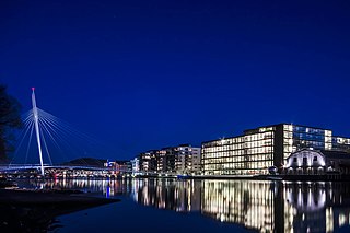
The Trondheim Fjord or Trondheimsfjorden, an inlet of the Norwegian Sea, is Norway's third-longest fjord at 130 kilometres (81 mi) long. It is located in the west-central part of the country in Trøndelag county, and it stretches from the municipality of Ørland in the west to the municipality of Steinkjer in the north, passing the city of Trondheim on its way. Its maximum depth is 617 metres (2,024 ft), between Agdenes and Indre Fosen.

Verdalsøra is a town in the municipality of Verdal in Trøndelag county, Norway. The town is the administrative center of the municipality. It is located along the Trondheimsfjord at the mouth of the river Verdalselva. The village of Vinne lies 4 kilometres (2.5 mi) to the southeast, Trones lies about 5 kilometres (3.1 mi) to the north, the villages of Forbregd/Lein lie about 4 kilometres (2.5 mi) to the northeast, and the village of Stiklestad lies about 3 kilometres (1.9 mi) to the east. In 1998, the municipal council of Verdal voted to grant the urban area of Verdalsøra town status under the laws of Norway.

Vuku is a village in the municipality of Verdal in Trøndelag county, Norway. It is located at the confluence of the rivers Helgåa and Inna where they become the Verdalselva river. The village is about 40 kilometres (25 mi) west of the village of Vera and about 15 kilometres (9.3 mi) east of the town of Verdalsøra. Vuku is also a parish covering the central part of Verdal municipality, with Vuku Church located in this village.

Bogvatnet (Norwegian) or Tjoamodisjávrre (Lule Sami) is a lake in the municipality of Rana in Nordland county, Norway. The lake is located inside the Saltfjellet–Svartisen National Park, about 40 kilometres (25 mi) north of the town of Mo i Rana. The glacial lake is also the headwaters of the Blakkåga river, a tributary to the main river Ranelva.
Unkervatnet (Norwegian) or Åanghkejaevrie (Southern Sami) is a lake in the municipality of Hattfjelldal in Nordland county, Norway. It is a good lake for fishing lake trout and Arctic char both during summer and winter. The river flowing into the lake from the east is called Skarmodalselva, and the outflowing river is called Unkerelva. For tourists, there are two places available by the shoreside: Ørnes camping at the eastern end of the lake, and Tjolmen, situated on the north side of the lake's middle. The road from the village of Hattfjelldal to the village of Dikanäs in Sweden runs along the north side of the lake.
Veresvatnet or Veressjøen is a lake in the municipality of Verdal in Trøndelag county, Norway. The lake lies in the eastern part of the municipality, just west of the border with Sweden and just south of Blåfjella–Skjækerfjella National Park. The 6.5-square-kilometre (2.5 sq mi) lake sits at an elevation of 360 metres (1,180 ft) above sea level, and it is considered to be one of the headwaters of the Verdalselva river since the lake's water flows out into the river Helgåa which later joins the Verdalselva. The village of Vera and the Vera Chapel lie on the northern shores of the lake.

Aursunden or Aursund is a lake in the municipality of Røros in Trøndelag county, Norway. The village of Brekken lies along the eastern shore and the village of Glåmos lies along the western shore.
The Hell–Sunnan Line is a 105-kilometer-long (65 mi) railway line between Hell, Stjørdal and Sunnan, Steinkjer in Nord-Trøndelag, Norway. The name is no longer in official use and the line is now considered part of the Nordland Line. The Hell–Sunnan Line branches from the Meråker Line at Hell and runs on the east shore of the Trondheimsfjord passing through the municipalities of Stjørdal, Levanger, Verdal, Inderøy and Steinkjer.
Namsvatnet (Norwegian) or Nååmesjenjaevrie (Southern Sami) is a 39.38-square-kilometre (15.20 sq mi) lake in the municipality of Røyrvik in Trøndelag county, Norway. The river Namsen used to be the primary outlet, but the lake has been regulated for hydroelectric generation since 1959 and part of the water is diverted south towards a power station. The lake is fed by three main sources within Børgefjell National Park: the river Storelva which comes from the lake Jengelvatnet, the river Virmaelva, and the river Orelva which comes from the lake Ovrejaevrie. Namsvatnet has Arctic char, trout, and small carp. Today, tourism is an important activity.

Nord-Trøndelag was a county constituting the northern part of the present-day Trøndelag county in Norway. The county was established in 1804 when the old Trondhjems amt was divided into two: Nordre Trondhjems amt and Søndre Trondhjems amt. In 2016, the two county councils voted to merge (back) into a single county on 1 January 2018.

Verdalselva is a 21-kilometre (13 mi) long river in the municipality of Verdal in Trøndelag county, Norway. The river begins at Holmen in the village of Vuku at the confluence of the rivers Inna and Helgåa. The river Inna drains the lake Innsvatnet near the Swedish border and the river Helgåa runs from the lake Veresvatnet at the village of Vera. The river Verdalselva flows west into the Trondheimsfjord, after passing through the town of Verdalsøra. The river Verdalselva is one of the country's best for salmon fishing.
Inna is a river that flows through the municipality of Verdal in Trøndelag county, Norway. The river begins in the east at the lake Innsvatnet, located near the border to Sweden, and it runs west to the village of Vuku at the confluence of the rivers Inna and Helgåa, which together become the river Verdalselva. The river Inna runs through the Inndalen valley, through the villages of Sul, Garnes, Holmen, and ends at Vuku.

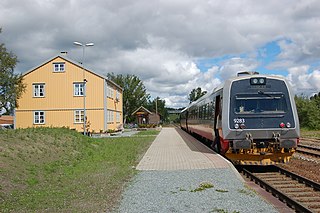
Vinne is a village in the municipality of Verdal in Trøndelag county, Norway. It is located just south of the Verdalselva river, about 4 kilometres (2.5 mi) southeast of the town of Verdalsøra and about the same distance to the west of the village of Lysthaugen. Vinne is also a parish covering the southern part of western Verdal municipality, with Vinne Church located in this village. The Bergsgrav Station is a train stop in Vinne along the Nordlandsbanen railway line.


