Namsskogan is a municipality in Trøndelag, Norway. Namsskogan is located in the upper part of the long Namdalen valley region. The administrative centre of the municipality is the village of Namsskogan. Other villages in the municipality include Brekkvasselv, Smalåsen, Skorovatn, and Trones.
The Rauma is a river that runs through Romsdalen, a valley in Møre og Romsdal and Oppland counties in Norway. It runs for 68 kilometres (42 mi) from Lesjaskogsvatnet, a lake in the municipality of Lesja, to the town of Åndalsnes in the municipality of Rauma. The river was once famous for its salmon-fishing, but since an infection with Gyrodactylus salaris only 5 to 10% of the original stock survives. The salmon runs up to the Slettafossen, a 16-metre (52 ft) high combination of waterfalls and rapids more than 42 kilometres (26 mi) upriver from the estuary.
Gauldal or Gauldalen is a valley and traditional district in Trøndelag county, Norway. The river Gaula runs through the 145-kilometre (90 mi) long valley from the Røros mountains near the lake Aursunden to the Trondheimsfjorden. The narrow valley runs northwards from Røros to the Haltdalen area, where it widens some, turns and heads generally to the west to the village of Støren. At Støren it turns again and heads north through what is now a wide, agricultural valley until it reaches the sea just south of the city of Trondheim. The Rørosbanen and Dovrebanen railway lines follow the Gauldalen valley on their way to Trondheim. The European route E06 highway and the Norwegian County Road 30 also follow the valley.

Verdalsøra is a town in the municipality of Verdal in Trøndelag county, Norway. The town is the administrative center of the municipality. It is located along the Trondheimsfjord at the mouth of the river Verdalselva. The village of Vinne lies 4 kilometres (2.5 mi) to the southeast, Trones lies about 5 kilometres (3.1 mi) to the north, the villages of Forbregd/Lein lie about 4 kilometres (2.5 mi) to the northeast, and the village of Stiklestad lies about 3 kilometres (1.9 mi) to the east. In 1998, the municipal council of Verdal voted to grant the urban area of Verdalsøra town status under the laws of Norway.

Vuku is a village in the municipality of Verdal in Trøndelag county, Norway. It is located at the confluence of the rivers Helgåa and Inna where they become the Verdalselva river. The village is about 40 kilometres (25 mi) west of the village of Vera and about 15 kilometres (9.3 mi) east of the town of Verdalsøra. Vuku is also a parish covering the central part of Verdal municipality, with Vuku Church located in this village.

Unkervatnet (Norwegian) or Åanghkejaevrie (Southern Sami) is a lake in the municipality of Hattfjelldal in Nordland county, Norway. It is a good lake for fishing lake trout and Arctic char both during summer and winter. The river flowing into the lake from the east is called Skarmodalselva, and the outflowing river is called Unkerelva. For tourists, there are two places available by the shoreside: Ørnes camping at the eastern end of the lake, and Tjolmen, situated on the north side of the lake's middle. The road from the village of Hattfjelldal to the village of Dikanäs in Sweden runs along the north side of the lake.
Åraksfjorden is a lake in the municipality of Bygland in Aust-Agder county, Norway. The 11.96-square-kilometre (4.62 sq mi) lake is part of the Otra drainage basin. The northern part of the lake is fed directly by the river Otra. The southern part of the lake goes through a narrow channel which leads into the Byglandsfjorden. The villages of Frøysnes and Skåmedal are located along the western side of the lake and on the eastern side are the villages of Sandnes and Åraksbø. The Norwegian National Road 9 runs along the eastern side of the lake.
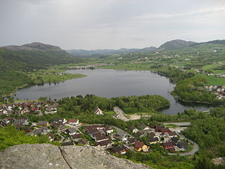
Frøylandsvatnet is a lake in the municipality of Sandnes in Rogaland county, Norway. The 0.48-square-kilometre (120-acre) lake lies on the south side of the village of Hommersåk, about 10 kilometres (6.2 mi) northeast of the city of Sandnes. The lake empties into a small river that runs out of the north end of the lake. The river runs through Hommersåk into an arm of the Gandsfjorden.
Innsvatnet is a lake in the municipality of Verdal in Trøndelag county, Norway. The lake lies in the eastern part of the municipality, just west of the border with Sweden. The lake is the headwaters for the river Inna, which later flows into the Verdalselva river. The 3.9-square-kilometre (1.5 sq mi) lake sits at an elevation of 415 metres (1,362 ft) above sea level.
Veresvatnet or Veressjøen is a lake in the municipality of Verdal in Trøndelag county, Norway. The lake lies in the eastern part of the municipality, just west of the border with Sweden and just south of Blåfjella–Skjækerfjella National Park. The 6.5-square-kilometre (2.5 sq mi) lake sits at an elevation of 360 metres (1,180 ft) above sea level, and it is considered to be one of the headwaters of the Verdalselva river since the lake's water flows out into the river Helgåa which later joins the Verdalselva. The village of Vera and the Vera Chapel lie on the northern shores of the lake.
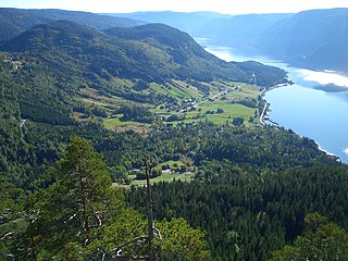
Eidfjordvatnet is a moraine-dammed lake in the municipality of Eidfjord in Hordaland county, Norway. The 3.55-square-kilometre (1.37 sq mi) lake is located immediately southeast of the village of Eidfjord. The village of Øvre Eidfjord lies on the southern shore of the lake. Norwegian National Road 7 runs along the western shore of the lake. The water enters the lake through the Bjoreio and Veig rivers, and the water empties from the lake through the Eio River.

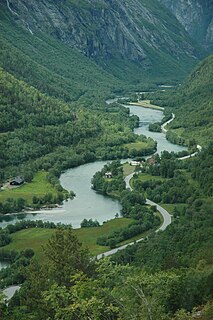
Verdalselva is a 21-kilometre (13 mi) long river in the municipality of Verdal in Trøndelag county, Norway. The river begins at Holmen in the village of Vuku at the confluence of the rivers Inna and Helgåa. The river Inna drains the lake Innsvatnet near the Swedish border and the river Helgåa runs from the lake Veresvatnet at the village of Vera. The river Verdalselva flows west into the Trondheimsfjord, after passing through the town of Verdalsøra. The river Verdalselva is one of the country's best for salmon fishing.
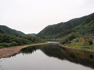
Helgåa is a river in the municipality of Verdal in Trøndelag county, Norway. The river begins at the lake Veresvatnet and runs through the valley Helgådalen for about 44 kilometres (27 mi) to Holmen in the village of Vuku, where it merges with the river Inna to create the river Verdalselva. At Granfossen there is a fish ladder.
Innset is a village in the municipality of Rennebu in Trøndelag county, Norway. The village is located along the Orkla River about 14 kilometres (8.7 mi) southeast of the village of Berkåk, about 5 kilometres (3.1 mi) southeast of the village of Ulsberg and about 22 kilometres (14 mi) northeast of the village of Kvikne. Innset Church is located in the village, just north of the Norwegian National Road 3.
Vera is a village in the municipality of Verdal in Trøndelag county, Norway. It is located on the northern shore of the lake Veresvatnet, about 4 kilometres (2.5 mi) west of the border with Sweden, about 2 kilometres (1.2 mi) south of the edge of Blåfjella–Skjækerfjella National Park, and about 40 kilometres (25 mi) east of the village of Vuku. Vera is also a parish covering the eastern part of Verdal municipality, with Vera Chapel located in this village.

Vinne is a village in the municipality of Verdal in Trøndelag county, Norway. It is located just south of the Verdalselva river, about 4 kilometres (2.5 mi) southeast of the town of Verdalsøra and about the same distance to the west of the village of Lysthaugen. Vinne is also a parish covering the southern part of western Verdal municipality, with Vinne Church located in this village. The Bergsgrav Station is a train stop in Vinne along the Nordlandsbanen railway line.
Lysthaugen is a village in the municipality of Verdal in Trøndelag county, Norway. It is located on the southern side of the river Verdalselva, about 10 kilometres (6.2 mi) east of the town of Verdalsøra and about 7 kilometres (4.3 mi) southwest of the village of Vuku. The mountain Skitholvola lies about 8 kilometres (5.0 mi) south of the village.
Vuku Church is a parish church of the Church of Norway in Verdal municipality in Trøndelag county, Norway. It is located in the village of Vuku. It is the church for the Vuku parish which is part of the Sør-Innherad prosti (deanery) in the Diocese of Nidaros. The red, wooden church was built in a long church style in 1654 by the architects Ole Johnsen Hindrum and Olluff Johnson Kirchebygger. The church seats about 200 people.

Norwegian National Road 7 is a national road in Norway which runs from the town of Hønefoss in Buskerud county to the village of Granvin in Hordaland county. The route is 387.6 kilometres (240.8 mi) long and runs east–west through Buskerud and Hordaland counties over the vast Hardangervidda plateau.


