
Snåsavatnet is Norway's sixth-largest lake. The 120-square-kilometre (46 sq mi) lake is located in the municipalities of Steinkjer and Snåsa in Trøndelag county, Norway. The villages of Følling and Sunnan lie at the southwestern end of the lake and the village of Snåsa lies at the northeastern end of the lake. The European route E6 highway runs along the northern shore of the lake and the Nordlandsbanen railway line runs along the southern shore.
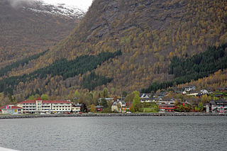
Skei is the administrative centre of the municipality of Jølster in Sogn og Fjordane county, Norway. The village is located at the northeastern end of the lake Jølstravatnet. Skei is 20 kilometres (12 mi) south of the village of Byrkjelo, 25 kilometres (16 mi) northeast of the villages of Vassenden/Langhaugane, and about 13 kilometres (8.1 mi) east of the village of Ålhus. Skei is located just west of Jostedalsbreen National Park. The village lies at the intersection of two major regional highways: European route E39 and Norwegian National Road 5.

Ålhus is a small village in the municipality of Jølster in Sogn og Fjordane county, Norway. It is located along the European route E39 highway on the northern side of the lake Jølstravatnet, in a largely agricultural area. Ålhus is located about 15 kilometres (9.3 mi) west of the villages of Helgheim and Skei and about 8 kilometres (5.0 mi) northeast of the villages of Vassenden and Langhaugane.
Bleiksvatnet is a lake in Andøy Municipality in Nordland county, Norway. The 1.74-square-kilometre (0.67 sq mi) lake is located just south of the village of Bleik on the island of Andøya. The lake sits at an elevation of 28 metres (92 ft) above sea level. The Bleikmorenen nature reserve is located on the northern shore of the lake.

Sausvatnet is a lake that is located in Brønnøy Municipality in Nordland county, Norway. There is also a small village on the eastern shore called Sausvatn. The lake is located about 7 kilometres (4.3 mi) south of the village of Hommelstø and about 15 kilometres (9.3 mi) northwest of the village of Lande.

Hostovatnet is a lake in Trøndelag county, Norway. The 3.14-square-kilometre (1.21 sq mi) lake lies on the border of the municipalities of Orkdal and Meldal. The village of Hoston is located on the northeastern shore of the lake.
Malmsjøen is a lake in the municipality of Skaun in Trøndelag county, Norway. It is located about 1.5 kilometres (0.93 mi) southeast of the village of Skaun, about 7 kilometres (4.3 mi) north of the village of Korsvegen, and about 10 kilometres (6.2 mi) southwest of the village of Melhus. The Norwegian County Road 709 runs along the northern shore of the lake.

Botsvatn or Bossvatn is a lake in the municipality of Bykle in Aust-Agder county, Norway. The 14.6-kilometre (9.1 mi) long, narrow reservoir is located just to the southeast of the large lake Blåsjø and northeast of the lake Ytre Storevatnet. The lake holds water for the Brokke Hydroelectric Power Station, located in nearby Valle municipality. The water from the lake can flow out into the nearby river Otra, but only when water is released from the dam.
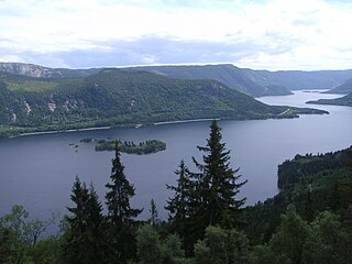
Byglandsfjorden is a lake in Aust-Agder county, Norway. The 32.79-square-kilometre (12.66 sq mi) lake lies on the river Otra, primarily in the municipality of Bygland, but the far southern tip of the lake extends into the neighboring municipality of Evje og Hornnes. The river flows out of the lake Åraksfjorden to the north and into the Byglandsfjorden through a narrow channel, and the southern end of the Byglandsfjorden is marked by a dam along the river. The villages of Byglandsfjord, Grendi, Longerak, Lauvdal, and Bygland are all located on the eastern shore of the lake along the Norwegian National Road 9. The western shore of the lake is much more sparsely populated, with County Road 304 following that shoreline.

Evangervatnet or Lake Evanger is a lake in the municipality of Voss in Hordaland county, Norway. The Vosso River flows through both Vangsvatnet and Evangervatnet before it empties into Bolstadfjorden by the village of Bolstadøyri. Evangervatnet is named for the village of Evanger, located on the eastern end of the lake. The last element vatnet is the definite form of vatn meaning lake.
Eidfjordvatnet is a moraine-dammed lake in the municipality of Eidfjord in Hordaland county, Norway. The 3.55-square-kilometre (1.37 sq mi) lake is located immediately southeast of the village of Eidfjord. The village of Øvre Eidfjord lies on the southern shore of the lake. Norwegian National Road 7 runs along the western shore of the lake. The water enters the lake through the Bjoreio and Veig rivers, and the water empties from the lake through the Eio River.

Røldalsvatnet is a lake in the municipality of Odda in Hordaland county, Norway. The 6.99-square-kilometre (2.70 sq mi) lake is located about 35 kilometres (22 mi) south of the town of Odda. The village of Røldal is located at the northern tip of the lake and the village of Botnen is located at the southern end. The European route E134 highway runs along the northern end of the lake, and the Norwegian National Road 13 runs along the western shore of the lake.

Kalandsvatnet is the largest lake in the municipality of Bergen in Hordaland county, Norway. The 3.5-square-kilometre (1.4 sq mi) lake is located in the borough of Fana, just east of the village of Fanahammeren. The European route E39 highway runs along the northeastern shore of the lake, about 12 kilometres (7.5 mi) south of the city centre of Bergen.

Øre or Ørevatn is a lake in the municipality of Åseral in Vest-Agder county, Norway. The 3.82-square-kilometre (1.47 sq mi) lake is located at the confluence of the rivers Logna and Monn at the village of Kyrkjebygda. Near the southern end of the lake, the river Mandalselva flows southwards. The village of Eikerapen lies along the southwestern shore of the lake.

Jølstravatnet or Jølstravatn is a lake in the municipality of Jølster in Sogn og Fjordane county, Norway. The lake empties its water into the 20-kilometre (12 mi) long Jølstra river which then flows into the Førdefjorden. The impressive eastern arm of Jølstravatn is called Kjøsnesfjorden, although it is not a true fjord that is part of the sea. The villages of Skei, Helgheim, Ålhus, and Vassenden are located on the shores of the lake.

Oppstrynsvatn is a lake in the municipality of Stryn in Sogn og Fjordane county, Norway. It is located about 8 kilometres (5.0 mi) east of the village of Stryn. The villages of Flo, Oppstryn, and Erdal are located on the shores of the lake.
Sandsjøen is a lake in the municipality of Lierne in Trøndelag county, Norway. It lies about 4 kilometres (2.5 mi) southeast of the municipal center, Sandvika. The village of Holand is located on the northern shore of Sandsjøen.
Eimhjellevatnet or Emhjellevatnet is a lake in Hyen area of Gloppen Municipality in Sogn og Fjordane county, Norway. The 11.39-square-kilometre (4.40 sq mi) lake is located in the western part of the municipality near the border with Flora Municipality. The villages of Eimhjellen and Solheim can be found along its shore and the village of Straume lies about 15 kilometres (9.3 mi) to the north. The lake lies about 25 kilometres (16 mi) southwest of the municipal center of Sandane. It is the second largest lake in all of Gloppen municipality and it has a good population of trout for fishing.

Helgheim Church is a parish church in Jølster Municipality in Sogn og Fjordane county, Norway. It is located in the village of Helgheim, right on the shore of the lake Jølstravatnet. The church is part of the Helgheim parish in the Sunnfjord deanery in the Diocese of Bjørgvin. The white, wooden church was built in 1877 by the architect Jacob Wilhelm Nordan. The church, which seats about 500 people, was consecrated on 28 November 1877 by the Bishop Peter Hersleb Graah Birkeland. The church was built on the same site as several previous, older churches. There has been a church on this site since the 13th century.


