Surnadal (help·info) is a municipality in Møre og Romsdal county, Norway. It is part of the Nordmøre region. The administrative centre is the village of Skei. Other villages in Surnadal include Glærem, Mo, Stangvik, Surnadalsøra, Sylte, Todalsøra, and Åsskard.

Førde is a municipality in the county of Sogn og Fjordane, Norway. It is located in the traditional district of Sunnfjord. The administrative center is the town of Førde which in 2016 had 10,255 inhabitants. Other villages in Førde municipality include Bruland, Holsen, Moskog, and Haukedalen. The Øyrane area in the town of Førde is a large industrial/commercial area for the region. The European Route E39 highway goes through the municipality, and it passes by the lake Holsavatnet.

Nordfjordeid is the administrative centre of the municipality of Eid in Sogn og Fjordane county, western Norway. It is located at the end of the Eidsfjorden, an arm off of the main Nordfjorden, west of the large lake Hornindalsvatnet. The village of Stårheim is located about 12 kilometres (7.5 mi) to the west, the village of Mogrenda is about 5 kilometres (3.1 mi) to the east, and the village of Lote is about 7 kilometres (4.3 mi) to the southeast.

Ålhus is a small village in the municipality of Jølster in Sogn og Fjordane county, Norway. It is located along the European route E39 highway on the northern side of the lake Jølstravatnet, in a largely agricultural area. Ålhus is located about 15 kilometres (9.3 mi) west of the villages of Helgheim and Skei and about 8 kilometres (5.0 mi) northeast of the villages of Vassenden and Langhaugane.

Vassenden is a village in the municipality of Jølster in Sogn og Fjordane county, Norway. It is located along the river Jølstra on the western shore of the lake Jølstravatnet, and about 10 kilometres (6.2 mi) north of the lake Holsavatnet. The 0.37-square-kilometre (91-acre) village has a population (2013) of 374, giving the village a population density of 1,011 per square kilometre (2,620/sq mi).
Langhaugane is a village along the river Jølstra in the municipality of Jølster in Sogn og Fjordane county, Norway. It is located along the European route E39 highway, about 2 kilometres (1.2 mi) west of the village of Vassenden, near the western end of the lake Jølstravatnet. The municipal center of Skei is 25 kilometres (16 mi) northeast of Langhaugane at the other end of the lake, and the town of Førde is located about 17 kilometres (11 mi) to the southwest.

Jølstravatnet or Jølstravatn is a lake in the municipality of Jølster in Sogn og Fjordane county, Norway. The lake empties its water into the 20-kilometre (12 mi) long Jølstra river which then flows into the Førdefjorden. The impressive eastern arm of Jølstravatn is called Kjøsnesfjorden, although it is not a true fjord that is part of the sea. The villages of Skei, Helgheim, Ålhus, and Vassenden are located on the shores of the lake.

Ogndal is a former municipality in what was the old Nord-Trøndelag county, Norway. The 418-square-kilometre (161 sq mi) municipality existed from 1885 until its dissolution in 1964. The municipality included the whole Ogndalen valley and areas to the west, up to, but not including the town of Steinkjer in what is now the central and western part of the municipality of Steinkjer in Trøndelag county. Starting in 1917, the administrative center of Ogndal was actually located in the town of Steinkjer.

Byrkjelo is a village in the municipality of Gloppen in Sogn og Fjordane county, Norway. It is located about halfway between the villages of Sandane and Skei along the European route E39 highway. The village of Re lies about 5 kilometres (3.1 mi) to the west and the small village of Egge lies about 5 kilometres (3.1 mi) to the south. The 0.49-square-kilometre (120-acre) village has a population (2013) of 286, giving the village a population density of 584 inhabitants per square kilometre (1,510/sq mi).

Fjærland is region in the municipality of Sogndal, at the end of the Fjærlandsfjorden, in Sogn og Fjordane county, Norway. The Fjærlandfjorden is a branch going north off the Sognefjorden, the longest fjord in Norway. The primary development in the region is the village Mundal located about 31 kilometres (19 mi) northwest of the municipal center of Sogndalsfjøra, along the Norwegian National Road 5. The region encompasses rich farming country, including the areas of Bøyum and Oygard.

Egge is a village in the municipality of Gloppen in Sogn og Fjordane county, Norway. It is located along the European route E39 highway, about 5 kilometres (3.1 mi) south of the village of Byrkjelo, and about 7 kilometres (4.3 mi) west of Jostedalsbreen National Park where the Myklebustbreen glacier is located. Egge is 21 kilometres (13 mi) southeast of the municipal center of Sandane, and it is also about 13 kilometres (8.1 mi) north of Skei, the municipal center of neighboring Jølster. The village sits at the base of the mountain Eggenipa.

Glærem is a village in Surnadal Municipality in Møre og Romsdal county, Norway. The village is located along the north shore of the Surnadalsfjorden, about 3 kilometres (1.9 mi) northwest of Sylte and about 5 kilometres (3.1 mi) northwest of Skei and Surnadalsøra. The 0.59-square-kilometre (150-acre) village has a population (2013) of 261.

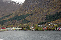
Surnadalsøra is a village in Surnadal Municipality in Møre og Romsdal county, Norway. It is located at the end of the Surnadalsfjorden, near the mouth of the river Surna. It is located just southwest of the villages of Sylte and Skei.
Skei is a village and the administrative center of Surnadal Municipality in Møre og Romsdal county, Norway. The village is located at near the end of the Surnadalsfjorden along the river Surna. It is about 1 kilometre (0.62 mi) northeast of the village of Surnadalsøra and about 2 kilometres (1.2 mi) southeast of the village of Sylte. There are two churches near Skei: Øye Church and Ranes Church.

The Grovabreen glacier is located in Sogn og Fjordane county, Norway. It covers an area of about 20 square kilometres (7.7 sq mi) in the municipalities of Førde and Jølster in the Sunnfjord region. The highest point on the glacier sits at an elevation of 1,636 metres (5,367 ft) above sea level. The glacier is part of Jostedalsbreen National Park, just south of the lake Jølstravatnet. The village of Skei lies about 8 kilometres (5.0 mi) north of the glacier and the village of Haukedalen lies about 9 kilometres (5.6 mi) southwest of the glacier. The Jostefonn glacier lies about 5 kilometres (3.1 mi) to the south of this glacier; both are located at the north end of the Gaularfjellet mountains.

The Jølstra is a river in the municipalities of Jølster and Førde in Sogn og Fjordane county, Norway. The 22-kilometre (14 mi) long river flows from the lake of Jølstravatnet down to the Førdefjorden. The river begins at the village of Vassenden, on the shores of the lake, it then goes past the village of Langhaugane, then past the Moskog area of Førde, past the village of Bruland, and it finally flows to its mouth at the town of Førde, on the shores of the fjord. There are four hydroelectric power stations in the river. The average rate of flow in Jølstra is given as 43.9 cubic metres per second (1,550 cu ft/s), measured at Høgset over the period from 1993 to 2011. The highest recorded flow rate during this period was 256 cubic metres per second (9,000 cu ft/s), while the lowest recorded flow rate was 1.2 cubic metres per second (42 cu ft/s).

Ålhus Church is a parish church in Jølster Municipality in Sogn og Fjordane county, Norway. It is located in the village of Ålhus on the northern shore of the lake Jølstravatnet. The church is part of the Ålhus parish in the Sunnfjord deanery in the Diocese of Bjørgvin.