
Årdalstangen is the administrative centre of the municipality Årdal in Sogn og Fjordane county, Norway. The village is one of the two main population centers in the municipality, along with the village of Øvre Årdal. The 1.08-square-kilometre (270-acre) village has a population (2013) of 1,489; giving the village a population density of 1,379 inhabitants per square kilometre (3,570/sq mi).

Nordfjord is a traditional district of Norway.

Sandane is the administrative centre of the municipality of Gloppen in Sogn og Fjordane county, Norway. It is located at the end of the Gloppefjorden, along the European route E39 highway. Sandane is 20 kilometres (12 mi) south of the village of Nordfjordeid and about 16 kilometres (9.9 mi) west of the village of Byrkjelo. Sandane Airport, Anda is located 10 kilometres (6.2 mi) northwest of Sandane along highway E39. Sandane has several suburban areas that surround the nearby fjord such as Sørstranda to the west and Vereide to the northwest.

Kasfjord is a village in Harstad Municipality in Troms county, Norway. The village is located at the end of the Kasfjorden on the north side of Hinnøya island, about 10 kilometres (6.2 mi) west of the town of Harstad and about 12 kilometres (7.5 mi) south of the village of Elgsnes. The Kasfjordvannet lake is located along the east side of the village. The 0.34-square-kilometre (84-acre) village has a population (2011) of 252. The population density is 741 inhabitants per square kilometre (1,920/sq mi).

Setermoen is the administrative centre of Bardu Municipality in Troms county, Norway. The village is located along the Barduelva river, about 25 kilometres (16 mi) east of the village of Sjøvegan and about 25 kilometres (16 mi) south of Bardufoss.

Bjørnevatn is a village in Sør-Varanger Municipality in Finnmark county, Norway. The village lies about 8 kilometres (5.0 mi) south of the town of Kirkenes and about 3.8 kilometres (2.4 mi) west of the Norway-Russia border. The village has a couple of suburbs including Hesseng to the north and Sandnes to the west. The Bjørnevatn IL is the local sports team.
Grodås is the administrative centre of Hornindal Municipality in Sogn og Fjordane county, Norway. The village is located along the river Horndøla on the eastern end of the lake Hornindalsvatnet, about 13 kilometres (8.1 mi) southwest of the mountain Hornindalsrokken. The village sits at the eastern end of the Kviven Tunnel, part of the new route for the European route E39 highway.

Sogndalsfjøra is the administrative center of the municipality of Sogndal in Sogn og Fjordane county, Norway. It is located where the river Sogndalselvi runs out in the Sogndalsfjorden, a branch of the large Sognefjorden. The village is located about 3.5 kilometres (2.2 mi) northwest of the village of Kjørnes, about 10 kilometres (6.2 mi) northwest of the village of Kaupanger, and about 31 kilometres (19 mi) southeast of the village of Fjærland.

Brandsøy (Brandsoy) is a village in the municipality of Flora in Sogn og Fjordane county, Norway. It is located on both sides of small strait that separates the east end of the island of Brandsøya and the mainland. The village sits along the Norwegian National Road 5 highway, about 6.9 kilometres (4.3 mi) east of the town of Florø and about 10 kilometres (6.2 mi) west of the village of Grov. The 0.4-square-kilometre (99-acre) village has a population (2013) of 420, giving the village a population density of 1,337 inhabitants per square kilometre (3,460/sq mi).

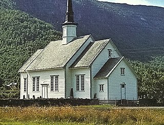
Sande is the administrative centre of the municipality of Gaular in Sogn og Fjordane county, Norway. The village is located along the Gaula River, about 10 kilometres (6.2 mi) from where the river meets the Dalsfjorden. The 0.59-square-kilometre (150-acre) village has a population (2013) of 745, giving the village a population density of 1,263 inhabitants per square kilometre (3,270/sq mi). Sande Church is located in this village, serving the people of the central part of the municipality.
Skei is the administrative centre of the municipality of Jølster in Sogn og Fjordane county, Norway. The village is located at the northeastern end of the lake Jølstravatnet. Skei is 20 kilometres (12 mi) south of the village of Byrkjelo, 25 kilometres (16 mi) northeast of the villages of Vassenden/Langhaugane, and about 13 kilometres (8.1 mi) east of the village of Ålhus. Skei is located just west of Jostedalsbreen National Park. The village lies at the intersection of two major regional highways: European route E39 and Norwegian National Road 5.

Vassenden is a village in the municipality of Jølster in Sogn og Fjordane county, Norway. It is located along the river Jølstra on the western shore of the lake Jølstravatnet, and about 10 kilometres (6.2 mi) north of the lake Holsavatnet. The 0.37-square-kilometre (91-acre) village has a population (2013) of 374, giving the village a population density of 1,011 per square kilometre (2,620/sq mi).

Breimsvatn or Breimsvatnet is a lake in the municipalities of Gloppen and Jølster in Sogn og Fjordane county, Norway. At 22.52 square kilometres (8.70 sq mi), it is the largest lake in Gloppen. The European route E39 highway runs along the north end of the lake, connecting the two nearby areas of Sandane and Byrkjelo. On the shores of the 17-kilometre (11 mi) long lake lie several villages including Re and Kandal. The lake flows into the Gloppenelva river which flows into the Gloppefjorden, an arm of the Nordfjorden. Historically, the area surrounding the lake was part of the municipality of Breim, which existed from 1886 until 1964.

Holskardvatnet is a lake in the municipality Vik in Sogn og Fjordane county, Norway. It is located just less than 100 metres (330 ft) north of the municipality border with Modalen in Hordaland county. The lake is 20 kilometres (12 mi) south of the village of Ortnevik in neighboring Høyanger Municipality, about 13 kilometres (8.1 mi) southwest of the village of Arnafjord, and about 28 kilometres (17 mi) southwest of the municipal center of Vikøyri. The 4.81 square kilometres (1.86 sq mi) lake is located at an elevation of 845 metres (2,772 ft) above sea level.

Etnesjøen or Etne is the administrative centre of Etne municipality in Hordaland county, Norway. The village is located at the inner end of the Etnefjorden, along the European route E134 highway, about 8 kilometres (5.0 mi) south of the village of Skånevik and about 10 kilometres (6.2 mi) northeast of the village of Ølensjøen.
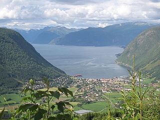
Vikøyri is the administrative center of the municipality of Vik in Sogn og Fjordane county, Norway. The village is located at the mouth of the Vikja river on the south shore of the Sognefjorden, roughly near the midpoint of Norway's longest fjord. The village lies along Norwegian National Road 13 which leads north to the ferry to Balestrand and south to the village of Vossevangen. The 1.26 square kilometres village of Vikøyri has a population (2013) of 1,195; giving the village a population density of 948 inhabitants per square kilometre (2,460/sq mi).
Bryggja is a village in eastern part of Vågsøy Municipality in Sogn og Fjordane county, Norway. It is located on the mainland, along the northern shore of the Nordfjorden. The village is located about 15 kilometres (9.3 mi) east of the urban area of Måløy–Deknepollen–Tennebø in Vågsøy and it is about 25 kilometres (16 mi) west of Stårheim in neighboring Eid municipality. The small village of Totland lies just west of Bryggja.
Søfteland or Syfteland is a village in Os municipality in Hordaland county, Norway. It lies on the Bergen Peninsula, along the European route E39 highway, about 6 kilometres (3.7 mi) north of the municipal centre of Osøyro and about 20 kilometres (12 mi) south of the city of Bergen. The mountain Møsnuken lies about 3.5 kilometres (2.2 mi) east of the village and the mountain Lyshornet lies about 2.3 kilometres (1.4 mi) west of the village. The 0.94-square-kilometre (230-acre) village has a population (2013) of 1425, giving the village a population density of 1,516 inhabitants per square kilometre (3,930/sq mi).
Eimhjellevatnet or Emhjellevatnet is a lake in Hyen area of Gloppen Municipality in Sogn og Fjordane county, Norway. The 11.39-square-kilometre (4.40 sq mi) lake is located in the western part of the municipality near the border with Flora Municipality. The villages of Eimhjellen and Solheim can be found along its shore and the village of Straume lies about 15 kilometres (9.3 mi) to the north. The lake lies about 25 kilometres (16 mi) southwest of the municipal center of Sandane. It is the second largest lake in all of Gloppen municipality and it has a good population of trout for fishing.

Eikefjord is a village in Flora Municipality in Sogn og Fjordane county, Norway. The village is located at the end of the Eikefjorden along the Norwegian National Road 5 highway. The town of Florø lies about 30 kilometres (19 mi) to the west and the village of Naustdal lies about 20 kilometres (12 mi) to the southeast (through the Naustdal Tunnel. The lake Endestadvatnet lies about 5 kilometres to the east. The villages of Nyttingnes and Steinhovden lie about 15 kilometres west of Eikefjord. The 0.4-square-kilometre village has a population of 368, giving the village a population density of 920 inhabitants per square kilometre.


