Hellfjorden (Vesterålen)

Last updated
Hellfjorden
Norway Nordland location map.svg
Red pog.svg
Hellfjorden
Location of the fjord
Relief Map of Norway.png
Red pog.svg
Hellfjorden
Hellfjorden (Norway)
Location Nordland county, Norway
Coordinates 68°40′42″N14°47′08″E / 68.6784°N 14.7856°E / 68.6784; 14.7856 Coordinates: 68°40′42″N14°47′08″E / 68.6784°N 14.7856°E / 68.6784; 14.7856
Type Fjord
Basin  countries Norway
Max. length6.5 kilometres (4.0 mi)
Max. width1.3 kilometres (0.81 mi)

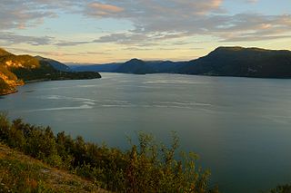
Hellfjorden is a fjord in Nordland county, Norway. [1] The 6.5-kilometre (4.0 mi) long fjord is an arm off of the main Eidsfjorden and the border between Sortland Municipality and Bø Municipality runs right down the middle of the fjord. The narrow fjord cuts into the large island of Langøya in the Vesterålen archipelago. The fjord lies in a very rugged, sparsely populated area.

Fjord A long, narrow inlet with steep sides or cliffs, created by glacial activity

Geologically, a fjord or fiord is a long, narrow inlet with steep sides or cliffs, created by a glacier. There are many fjords on the coasts of Alaska, Antarctica, British Columbia, Chile, Greenland, the Faroe Islands, Iceland, Kamchatka, the Kerguelen Islands, New Zealand, Norway, Novaya Zemlya, Labrador, Nunavut, Newfoundland, Quebec, Scotland, South Georgia Island, and Washington state. Norway's coastline is estimated at 29,000 kilometres (18,000 mi) with nearly 1,200 fjords, but only 2,500 kilometres (1,600 mi) when fjords are excluded.

Nordland County (fylke) of Norway

Nordland is a county in Norway in the Northern Norway region, bordering Troms in the north, Trøndelag in the south, Norrbotten County in Sweden to the east, Västerbotten County to the southeast, and the Atlantic Ocean to the west. The county was formerly known as Nordlandene amt. The county administration is in Bodø. The remote Arctic island of Jan Mayen has been administered from Nordland since 1995.

Norway constitutional monarchy in Northern Europe

Norway, officially the Kingdom of Norway, is a Nordic country in Northwestern Europe whose territory comprises the western and northernmost portion of the Scandinavian Peninsula; the remote island of Jan Mayen and the archipelago of Svalbard are also part of the Kingdom of Norway. The Antarctic Peter I Island and the sub-Antarctic Bouvet Island are dependent territories and thus not considered part of the kingdom. Norway also lays claim to a section of Antarctica known as Queen Maud Land.

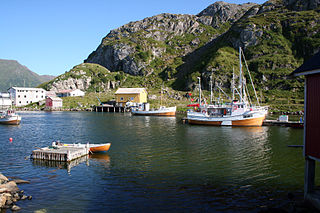
The bay has an inlet between the Oksneset headland, just east of the village of Guvåg on the west side of the fjord and the Hellfjordklubben peninsula on the east side of the fjord. There are many islands in the outer part of the fjord including Storøya, Ramnøya, Torskøya, and Slåttøya. Further into the fjord lie the islands of Reinøya and Teistøya. Vestpolløya is a small peninsula near the head of the fjord. There are no major settlements along the fjord and no road connections to the fjord, so it is only accessible by boat or by hiking. The now-abandoned farm named Hellfjorden is located on the east side of the bay in Sortland Municipality.

A headland is a coastal landform, a point of land usually high and often with a sheer drop, that extends into a body of water. It is a type of promontory. A headland of considerable size often is called a cape. Headlands are characterised by high, breaking waves, rocky shores, intense erosion, and steep sea cliffs.

Guvåg Village in Northern Norway, Norway

Guvåg is a village in Bø Municipality in Nordland county, Norway. The village is located on the shore of Eidsfjord between the mouth of Jørnfjorden to the east and Hellfjorden to the west. Many skerries lie in the sea near Guvåg. Ørntuva Hill rises immediately north of Guvåg, with the Breitinden Plateau rising beyond that.

Peninsula A piece of land that is bordered by water on three sides but connected to mainland

A peninsula is a landform surrounded by water on the majority of its border while being connected to a mainland from which it extends. The surrounding water is usually understood to be continuous, though not necessarily named as a single body of water. Peninsulas are not always named as such; one can also be a headland, cape, island promontory, bill, point, or spit. A point is generally considered a tapering piece of land projecting into a body of water that is less prominent than a cape. A river which courses through a very tight meander is also sometimes said to form a "peninsula" within the loop of water. In English, the plural versions of peninsula are peninsulas and, less commonly, peninsulae.

See also

Related Research Articles

may refer to the following:

Bø, Nordland Municipality in Nordland, Norway

is a municipality in Nordland county, Norway. It is part of the Vesterålen region. The administrative centre of the municipality is the village of Straume. Other villages in the municipality include Auvåg, the village of Bø, Eidet, Guvåg, Hovden, Klakksjorda, Malnes, Nykvåg, Utskor, and Vågen. The Litløy Lighthouse is located on the tiny island of Litløya off the coast of Bø.

Øksnes Municipality in Nordland, Norway

Øksnes is a municipality in Nordland county, Norway. It is located on the northwestern part of the large island of Langøya, which is a part of the traditional region of Vesterålen. The administrative centre of the municipality is the village of Myre. Other villages in Øksnes include Alsvåg, Barkestad, Breidstrand, Nyksund, Strengelvåg, and Stø.

Hinnøya large island of Troms and Nordland, Norway

Hinnøya is the fourth largest island in Norway. The 2,204.7-square-kilometre (851.2 sq mi) lies just off the western coast of Northern Norway. The island sits on the border of Nordland and Troms counties. The western part of the island is in the district of Vesterålen, the southwestern part is in the Lofoten district, the southeastern part is in the Ofoten district, and the northeastern part is in Southern Troms.

Vesterålen archipelago and district in Norway

Vesterålen is a district and archipelago in Nordland county, Norway. It is located just north of the Lofoten district and archipelago and west of the town of Harstad. It is the northernmost part of Nordland county, including the municipalities of Andøy, Bø, Hadsel, Sortland, and Øksnes.

Bø, Sortland Village in Northern Norway, Norway

is a village in Sortland Municipality in Nordland county, Norway. The village is located on the island of Langøya along the Sortlandssundet strait, about 6 kilometres (3.7 mi) southwest of the town of Sortland and about 4 kilometres (2.5 mi) northeast of the village of Holand.

Langøya island in Nordland, Norway

Langøya is the third largest island of Norway, with an area of 850.2 square kilometres (328.3 sq mi). The island is a part of the Vesterålen archipelago in Nordland county, Norway. The island includes the municipalities of Bø and Øksnes as well as parts of the municipalities of Sortland and Hadsel.

Gullesfjorden fjord in Kvæfjord, Norway

Gullesfjorden is a fjord that cuts into the island of Hinnøya in Troms county, Norway. It is located mostly within Kvæfjord Municipality, although a small part in the northwestern part of the fjord lies in Sortland Municipality in Nordland county. The inner head of the ford is known as Gullesfjordbotn.

Forfjorden fjord in Nordland, Norway

Forfjorden is a fjord on the west side of the island of Hinnøya in the Vesterålen archipelago in Nordland county, Norway. The fjord lies along the border between Sortland Municipality and Andøy Municipality. The Norwegian County Road 82 follows the shoreline around the whole fjord. The coast around the Forfjorden has about 70 inhabitants. The fjord is located about 30 kilometres (19 mi) northeast of the town of Sortland and about 70 kilometres (43 mi) south of Andenes. The name is derived from its surrounding pine forest, as "Furu" and "Forra" translates to pine tree. The 7-kilometre (4.3 mi) long fjord flows to the west and joins the Gavlfjorden along with the Risøysundet and Sortlandssundet straits.

Eidsfjorden (Nordland) fjord in Nordland, Norway

Eidsfjorden is a fjord in Nordland county, Norway. The 25-kilometre (16 mi) long fjord cuts into the island of Langøya in the Vesterålen archipelago and it is located in the municipalities of Bø, Hadsel, and Sortland. It branches off of the main Vesterålsfjorden which is part of Norwegian Sea. The innermost part of the fjord is part of Sortland Municipality. The outer part of the fjord is split with the western coast belonging to Bø Municipality and the eastern coast belonging to Hadsel Municipality.

Valen, Bindal fjord arm in Norway

Valen is an arm of the Kjelda fjord in Bindal municipality in Nordland in Norway. It gets its name from a hamlet of the same name which lies at its south-eastern end.

Straumsfjorden or Straumfjorden may refer to the following places in Norway:

Saltdal Fjord fjord in Saltdal, Norway

Saltdal Fjord is a fjord arm of Skjerstad Fjord in the municipality of Saltdal in Nordland county, Norway. The fjord extends 11 kilometers (6.8 mi) south to the village of Rognan at the bottom of the fjord.

Malnesfjord fjord in Vesterålen, Norway

Malnesfjorden or Malnesfjord is a fjord in Bø Municipality in Nordland county, Norway. The 6.5-kilometre (4.0 mi) long fjord is located between two peninsulas on the northwestern part of the island of Langøya in the Vesterålen archipelago. The inlet to the fjord lies between the village of Hovden to the northwest and the Godvika inlet to the northeast. The fjord reaches a depth of 161 meters (528 ft) southwest of Godvika. The mountain Malnesberget lies on the western shore of the fjord.

Norwegian County Road 820 county road in Nordland, Norway

County Road 820 is a 73.1-kilometer (45.4 mi) road in the municipalities of Bø, Øksnes, and Sortland in Nordland County, Norway. It starts in the village of Straumsnes in the municipality of Bø, where it continues south from County Road 901, circles around the west end of the island of Langøya through the Straume Nature Reserve to the village of Straume, and continues east to the Ryggedal Tunnel. It then passes through the municipality of Øksnes along the west shore of Ånnfjord and south shore of Skjellfjord before entering the municipality of Sortland. There it passes along the inner shore of Eidsfjord through Frøskeland, crosses Vikeid, where County Road 956 branches off to Vik, and then runs past the southwest shore of the Vikosen Nature Reserve and along the west side of Sortlandssundet strait, where it terminates at the town of Sortland.

Frøskeland Settlement in Northern Norway, Norway

Frøskeland is a village in Sortland Municipality in Nordland county, Norway.

Vikeid isthmus in Sortland, Norway

Vikeid is a flat isthmus on the island of Langøya in the municipality of Sortland in Nordland county, Norway. The village of Vik lies on the east side of the isthmus and the village of Frøskeland lies on the west side. The isthmus has the Eidsfjorden to the west and the Sortlandsundet strait in the east. The isthmus almost divides Langøya in two. To the north lies the northwestern part of the municipality of Sortland, and further north the municipality of Øksnes. The southwest part of the municipality of Sortland lies south of the isthmus. The Eidsfjorden and the western part of the isthmus belonged to the municipality of Hadsel until 1963 when it was transferred to Sortland.

Vik, Sortland Village in Northern Norway, Norway

Vik is a village in Sortland Municipality in Nordland county, Norway. The village is located on the island of Langøya, about 13 kilometers (8.1 mi) north of the town of Sortland.

Jørnfjorden

Jørnfjorden is a fjord in Bø Municipality in Nordland county, Norway. The 7-kilometre (4.3 mi) long fjord is an arm of Eidsfjorden, cutting into the large island of Langøya in the Vesterålen archipelago. The inlet to the ford lies between the villages of Straumsnes to the west and Guvåg to the east. The fjord extends 7 kilometers (4.3 mi) north to the village of Verhalsen. The fjord reaches a depth of 67 metres (220 ft) just northeast of the small village of Auvåg.

Sagfjorden (Nordland) fjord in Nordland, Norway

Sagfjorden (Norwegian) or Rivtakvuodna (Northern Sami) is a fjord in Nordland county, Norway. The 38-kilometre (24 mi) long fjord forms part of the boundary between the municipalities of Hamarøy and Steigen. There are several large islands in the fjord as well: Finnøya to the north and Lundøya and Engeløya at the mouth of the fjord where it joins the Vestfjorden.

References

  1. "Hellfjorden, Bø (Nordland)" (in Norwegian). yr.no . Retrieved 2018-12-29.