
Mirfield is a town and civil parish in the Metropolitan Borough of Kirklees, West Yorkshire, England. Historically part of the West Riding of Yorkshire, it is on the A644 road between Brighouse and Dewsbury. At the 2011 census it had a population of 19,563. Mirfield forms part of the Heavy Woollen District.
Marsden is a large village in the Colne Valley, in the metropolitan borough of Kirklees, West Yorkshire, England. It is in the South Pennines close to the Peak District which lies to the south. The village is 7 miles (11 km) west of Huddersfield at the confluence of the River Colne and Wessenden Brook. It was an important centre for the production of woollen cloth. In 2020, the village had an estimated population of 3,768.

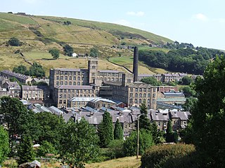
Meltham is a town and civil parish within the Metropolitan Borough of Kirklees, in West Yorkshire, England. It lies in the Holme Valley, below Wessenden Moor, 5 miles south-west of Huddersfield on the edge of the Peak District National Park. It had a population of 8,089 at the 2001 census, which was estimated to have increased to 8,600 by 2005. The population assessed at the 2011 Census was 8,534. It has 12 elected council members who meet up around every 6 weeks.

Shelley is a village in the civil parish of Kirkburton, in the Kirklees district, in the county of West Yorkshire, England. The village is 3 miles (5 km) north of Holmfirth and 6 miles (10 km) south-east of Huddersfield.
Honley is a village in the Holme Valley civil parish in Kirklees, West Yorkshire, England. Historically part of the West Riding of Yorkshire, it is situated near to Holmfirth and Huddersfield, and on the banks of the River Holme. According to the 2011 Census it had a population of 6,474, a growth of 577 from the 2001 Census

Lockwood is an area of Huddersfield, in the Metropolitan Borough of Kirklees, West Yorkshire, England. It is 0.9 miles (1.4 km) to the southwest of Huddersfield Town Centre, to the west of the River Holme.

Derry Hill is a village in the English county of Wiltshire, in the civil parish of Calne Without. It has an elevated position at the northern edge of the Bowood House estate, about 3 miles (5 km) south-east of the centre of the town of Chippenham.

Shepley is a village in the civil parish of Kirkburton, in Kirklees, West Yorkshire, England. It lies 8 miles (13 km) south south east of Huddersfield and 6 miles (9.7 km) north west of Penistone.

Almondbury is a village 2 miles (3.2 km) south-east of Huddersfield town centre in the Kirklees district, of West Yorkshire, England. The population of Almondbury in 2001 was 7,368 increasing to 18,346 at the 2011 census.

Brockholes is a small village in West Yorkshire, England, in the administrative area of Kirklees Metropolitan Council and Holme Valley Parish Council. The village of Honley borders to the immediate north of the village and Holmfirth lies to the south. Brockholes is within the Postal district of Holmfirth.

Christian Malford is a village and civil parish in the county of Wiltshire, England. The village lies about 4+1⁄2 miles (7 km) northeast of the town of Chippenham. The Bristol Avon forms most of the northern and eastern boundaries of the parish. The hamlets of Thornend and Upper Town lie within the parish.

Minshull Vernon is a hamlet and civil parish in the unitary authority of Cheshire East and the ceremonial county of Cheshire, England. The hamlet lies 3 miles (5 km) to the north west of Crewe, south east of Winsford and south west of Middlewich. The parish also includes the small settlements of Bradfield Green, Eardswick, Hoolgrave, Minshull Hill, Walley's Green and Weaver Bank. The total population of the civil parish is somewhat over 200, measured at 391 in the Census 2011. Nearby villages include Church Minshull, Warmingham and Wimboldsley.

Worton is a village and civil parish about 3 miles (5 km) southwest of Devizes in Wiltshire. It is near the northern edge of Salisbury Plain in central southern England.

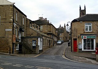
Barkisland is a village in Calderdale, West Yorkshire, England. Historically part of the West Riding of Yorkshire, it is 1 mile (1.6 km) east of Ripponden, 2 miles (3.2 km) south of Sowerby Bridge and 4 miles (6.4 km) south-west of Halifax town centre.
Hankelow is a village and civil parish in the unitary authority of Cheshire East and the ceremonial county of Cheshire, England. The village lies on the A529, around 1.25 miles (2.0 km) north east of Audlem and 4.5 miles (7.2 km) south of Nantwich. The civil parish has an area 369 hectares and also includes the small settlement of The Dell and part of Corbrook, with a total population of just over 260 in 2011. Nearby villages include Aston, Broomhall Green, Sound, Hatherton and Buerton in Cheshire and Woore in Shropshire.

William Swinden Barber FRIBA, also W. S. Barber or W. Swinden Barber, was an English Gothic Revival and Arts and Crafts architect, specialising in modest but finely furnished Anglican churches, often with crenellated bell-towers. He was based in Brighouse and Halifax in the West Riding of Yorkshire. At least 15 surviving examples of his work are Grade II listed buildings, including his 1875 design for the Victoria Cross at Akroydon, Halifax. An 1864 portrait by David Wilkie Wynfield depicts him in Romantic garb, holding a flower. He served in the Artists Rifles regiment in the 1860s alongside Wynfield and other contemporary artists.
The former St Mark's Church, Old Leeds Road, Huddersfield, was an Anglican parish church in West Yorkshire, England. It was previously known as St Mark's, Leeds Road, before the road name was changed. This building was designed in 1886 by William Swinden Barber when the parish of St Peter's was split and a new building was required to accommodate a growing congregation. It was opened in 1887. Among the vicars posted in this benefice were the very popular Canon Percy Holbrook, the notoriously unfortunate Reverend Jonas Pilling who was involved in a standoff with his congregation for many years, the sociable Reverend Robert Alfred Humble who died in mysterious circumstances, and the eloquent preacher Reverend Joseph Miller, who had previously been a Congregational minister. The building was sold by the Church of England in 2001, and it has been converted into a block of offices.
Meltham is a civil parish in the metropolitan borough of Kirklees, West Yorkshire, England. It contains 60 listed buildings that are recorded in the National Heritage List for England. Of these, one is listed at Grade II*, the middle of the three grades, and the others are at Grade II, the lowest grade. The parish contains the village of Meltham and the smaller settlements of Helme and Wilshaw, and is otherwise rural. Until the Industrial Revolution the economy of the parish depended mainly on agriculture, and many of the listed buildings are farmhouses and farm buildings. The Industrial Revolution brought the textile industry to the area, and this was initially a domestic process. Many of the listed buildings are weavers' cottages and other houses used for spinning wool, and these are characterised by long rows of mullioned windows, mainly in the upper storeys. Most of the listed buildings are constructed from stone and have roofs of stone slate. The other listed buildings include other houses and associated structures, churches and items in churchyards, former Sunday schools, a well head, milestones, boundary markers, a bridge, two kissing gates, mills, a mausoleum, almshouses, a village hall, and a telephone kiosk.

Meltham Town Hall is a municipal building in Carlile Street in Meltham, West Yorkshire, England. The building, which formerly operated as the offices of Meltham Urban District Council, is now The Crossroads Centre, which operates the local foodbank.

