Hem, Netherlands

Last updated
Hem
Hem3.jpg
Coordinates: 52°39′40″N5°10′59″E / 52.66111°N 5.18306°E / 52.66111; 5.18306 Coordinates: 52°39′40″N5°10′59″E / 52.66111°N 5.18306°E / 52.66111; 5.18306
Country Netherlands
Province North Holland
Municipality Drechterland
Population (2007) 1,220

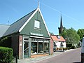
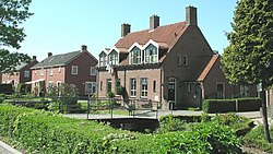
Hem (West Frisian: Him) (population estimate: 1230) is a village in the municipality Drechterland, located in the north west of the Netherlands, in the province of North Holland and the region of West-Frisia.

Drechterland Municipality in North Holland, Netherlands

Drechterland is a municipality in the Netherlands, in the province of North Holland and the region of West-Frisia. The municipality was formed in 1979, in a merger of the former municipalities of Hoogkarspel, Westwoud en Oosterblokker. Its original name, Bangert, was changed to "Drechterland" in 1980. In 2006, the former municipality of Venhuizen was added to Drechterland.

Netherlands Constituent country of the Kingdom of the Netherlands in Europe

The Netherlands is a country located mainly in Northwestern Europe. The European portion of the Netherlands consists of twelve separate provinces that border Germany to the east, Belgium to the south, and the North Sea to the northwest, with maritime borders in the North Sea with Belgium, Germany and the United Kingdom. Together with three island territories in the Caribbean Sea—Bonaire, Sint Eustatius and Saba— it forms a constituent country of the Kingdom of the Netherlands. The official language is Dutch, but a secondary official language in the province of Friesland is West Frisian.

North Holland Province of the Netherlands

North Holland is a province of the Netherlands located in the northwestern part of the country. It is situated on the North Sea, north of South Holland and Utrecht, and west of Friesland and Flevoland. In 2015, it had a population of 2,762,163 and a total area of 2,670 km2 (1,030 sq mi).

Notable people


Related Research Articles

North Africa Northernmost region of Africa

North Africa is a region encompassing the northern portion of the African continent. There is no singularly accepted scope for the region, and it is sometimes defined as stretching from the Atlantic shores of Morocco in the west, to Egypt's Suez Canal and the Red Sea in the east. Others have limited it to top North-Western countries like Algeria, Morocco, and Tunisia, a region that was known by the French during colonial times as "Afrique du Nord" and is known by all Arabs as the Maghreb. The most commonly accepted definition includes Algeria, Sudan, Morocco, Tunisia, Libya and Egypt, the 6 countries that shape the top North of the African continent. Meanwhile, "North Africa", particularly when used in the term North Africa and the Middle East, often refers only to the countries of the Maghreb and Libya. Egypt, being also part of the Middle East, is often considered separately, due to being both North African and Middle Eastern at the same time.

North West England Place in England

North West England, one of nine official regions of England, consists of the five counties of Cheshire, Cumbria, Greater Manchester, Lancashire and Merseyside. The North West had a population of 7,052,000 in 2011. It is the third-most populated region in the United Kingdom after the South East and Greater London. The largest settlements are Manchester, Liverpool, Warrington, Preston, and Blackpool.

Frisia coastal region on the North Sea in the Netherlands and Germany formerly a historic region with its own language

Frisia is a coastal region along the southeastern corner of the North Sea in what today is mostly a large part of the Netherlands, including modern Friesland and smaller parts of northern Germany. Frisia is the traditional homeland of the Frisians, a Germanic people that speaks Frisian languages, which together with English and Scots form the Anglo-Frisian language group.

North Yorkshire County of England

North Yorkshire is a non-metropolitan county and largest ceremonial county in England. It is located primarily in the region of Yorkshire and the Humber but partly in the region of North East England. The estimated population of North Yorkshire was 602,300 in mid 2016.

West Yorkshire County of England

West Yorkshire is a metropolitan county in England. It is an inland and in relative terms upland county having eastward-draining valleys while taking in moors of the Pennines and has a population of 2.2 million. West Yorkshire came into existence as a metropolitan county in 1974 after the passage of the Local Government Act 1972.

North Germanic languages Branch of Germanic languages spoken predominantly in the Nordic countries

The North Germanic languages make up one of the three branches of the Germanic languages, a sub-family of the Indo-European languages, along with the West Germanic languages and the extinct East Germanic languages. The language group is sometimes referred to as the "Nordic languages", a direct translation of the most common term used among Danish, Faroese, Icelandic, Norwegian, and Swedish scholars and laypeople.

The West Germanic languages constitute the largest of the three branches of the Germanic family of languages.

Lesser Antilles Archipelago in the Southeast Caribbean

The Lesser Antilles is a group of islands in the Caribbean Sea. Most form a long, partly volcanic island arc between the Greater Antilles to the north-west and the continent of South America. The islands form the eastern boundary of the Caribbean Sea with the Atlantic Ocean. Together, the Lesser Antilles and the Greater Antilles compose the Antilles. When combined with the Lucayan Archipelago, all three are known as the West Indies.

Provinces of Indonesia Indonesian administrative division, first-level subdivision of the country

The Provinces of Indonesia are the 34 largest subdivisions of the country and the highest tier of the local government. Provinces are further divided into regencies and cities, which are in turn subdivided into subdistricts (kecamatan).

West Coast of the United States Coastline

The West Coast or Pacific Coast is the coastline along which the continental Western United States meets the North Pacific Ocean. As a region, this term most often refers to the coastal states of California, Oregon, Washington, and Alaska. More specifically, it refers to an area defined on the east by the Alaska Range, Cascade Range, Sierra Nevada, and Mojave Desert, and on the west by the Pacific Ocean. The United States Census groups the five states of California, Oregon, Washington, Alaska, and Hawaii together as the Pacific States division.

Points of the compass Directional divisions marked on a compass

The points of the compass mark the divisions on a compass, which is primarily divided into the four cardinal directions: north, south, east, and west. These points are further subdivided by the addition of the four intercardinal directions—northeast (NE), southeast (SE), southwest (SW), and northwest (NW)—to indicate the eight principal winds. In meteorological usage, further intermediate points between the cardinal and intercardinal directions, such as north-northeast (NNE) are added to give the sixteen points of a compass rose.

Ceremonial counties of England Collective name for areas, in England, to which a Lord Lieutenant is appointed

The ceremonial counties, also referred to as the lieutenancy areas of England, are areas of England to which a Lord Lieutenant is appointed. Legally the areas in England, as well as in Wales and Scotland, are defined by the Lieutenancies Act 1997 as counties and areas for the purposes of the lieutenancies in Great Britain, in contrast to the areas used for local government. They are also informally known as geographic counties, as often representing more permanent features of English geography, and to distinguish them from counties of England which have a present-day administrative function.

Ordnance Survey National Grid System of geographic grid references used in Great Britain

The Ordnance Survey National Grid reference system is a system of geographic grid references used in Great Britain, distinct from latitude and longitude. It is often called British National Grid (BNG).

North Caucasus Geographic region

The North Caucasus or Ciscaucasia is the northern part of the Caucasus region between the Sea of Azov and Black Sea on the west and the Caspian Sea on the east, within Asian Russia. Geographically, the Northern Caucasus includes the Russian republics and krais of the North Caucasus. As part of the Russian Federation, the Northern Caucasus region is included in the North Caucasian and Southern Federal Districts and consists of Krasnodar Krai, Stavropol Krai, and the constituent republics, approximately from west to east: the Republic of Adygea, Karachay–Cherkessia, Kabardino-Balkaria, North Ossetia–Alania, Ingushetia, Chechnya, and the Republic of Dagestan.

Time in the United States Timekeeping in the USA

Time in the United States, by law, is divided into nine standard time zones covering the states and its possessions, with most of the United States observing daylight saving time (DST) for approximately the spring, summer, and fall months. The time zone boundaries and DST observance are regulated by the Department of Transportation. Official and highly precise timekeeping services (clocks) are provided by two federal agencies: the National Institute of Standards and Technology (NIST) ; and its military counterpart, the United States Naval Observatory (USNO). The clocks run by these services are kept synchronized with each other as well as with those of other international timekeeping organizations.

North West England (European Parliament constituency) constituency of the European Parliament

North West England is a constituency of the European Parliament. From the 2009 elections it elects 8 MEPs using the d'Hondt method of party-list proportional representation.

British America English territories in North America

British America included the British Empire's colonial territories in North America and Central America, Bermuda, the Caribbean, and Guyana from 1607 to 1783. The American colonies were formally known as British America and the British West Indies before the Thirteen Colonies declared their independence in the American Revolutionary War (1775–1783) and formed the United States of America. After that, the term British North America was used to describe the remainder of Britain's continental American possessions. That term was used informally in 1783 by the end of the American Revolution, but it was uncommon before the Report on the Affairs of British North America (1839), called the Durham Report.

West Indies Island region in the Caribbean

The West Indies is a region of the North Atlantic Ocean and the Caribbean that includes the island countries and surrounding waters of three major archipelagos: the Greater Antilles, the Lesser Antilles and the Lucayan Archipelago.

Caribbean region to the center-east of America composed of many islands and of coastal regions of continental countries surrounding the Caribbean Sea

The Caribbean is a region of The Americas that consists of the Caribbean Sea, its islands and the surrounding coasts. The region is southeast of the Gulf of Mexico and the North American mainland, east of Central America, and north of South America.