
Surrey is a county in South East England which borders Kent to the east, East Sussex to the southeast, West Sussex to the south, Hampshire to the west, Berkshire to the northwest, and Greater London to the northeast. With about 1.2 million people, Surrey is the 12th-most populous English county, the third-most populous home county, after Kent and Essex, and the third-most populous in the Southeast, after Hampshire and Kent.

Guildford is a town in Surrey, England. It lies 28 miles (45 km) southwest of London on the A3 trunk road between the capital and Portsmouth. As of the 2011 census, the town has a population of about 80,000 and is the seat of the wider Borough of Guildford which had an estimated 147,889 inhabitants in 2018.

The University of Surrey is a public research university in Guildford, Surrey, England. The university received its royal charter in 1966, along with a number of other institutions following recommendations in the Robbins Report. The institution was previously known as Battersea College of Technology and was located in Battersea Park, London. Its roots however, go back to Battersea Polytechnic Institute, founded in 1891 to provide further and higher education in London, including its poorer inhabitants. The university's research output and global partnerships have led to it being regarded as one of the UK's leading research universities.

Cranleigh is a village and civil parish, about 8 miles (13 km) southeast of Guildford in Surrey, England. It lies on a minor road east of the A281, which links Guildford with Horsham. It is in the north-west corner of the Weald, a large remnant forest, the main local remnant being Winterfold Forest directly north-west on the northern Greensand Ridge.

Camberley is a town in the Borough of Surrey Heath in Surrey, England, approximately 31 miles (50 km) southwest of Central London. The town is in the far west of the county, close to the borders of Hampshire and Berkshire. Once part of Windsor Forest, Camberley grew up around the Royal Military Academy Sandhurst and the associated Army Staff College. Known originally as Cambridge Town, it was assigned its current name by the General Post Office in 1877.

Send is a village and civil parish in the Guildford borough of the English county of Surrey. Send acquired its name during the Great Vowel Shift from the word sand, which was extracted at various periods until the 1990s for construction and other purposes at pits in the outskirts of the parish. The north of Send is at the southern-eastern edge of the Bagshot Formation.

The London Defence Positions were a late 19th century scheme of earthwork fortifications in the south-east of England, designed to protect London from foreign invasion landing on the south coast. The positions were a carefully surveyed contingency plan for a line of entrenchments, which could be quickly excavated in a time of emergency. The line to be followed by these entrenchments was supported by thirteen permanent small polygonal forts or redoubts called London Mobilisation Centres, which were equipped with all the stores and ammunition that would be needed by the troops tasked with digging and manning the positions.
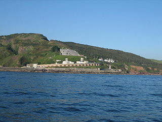
Fort Bovisand is a fort in Devon, England near the beach of Bovisand. It was built as a result of the Royal Commission on the Defence of the United Kingdom which reported in 1860. It is located on the mainland to defend the entrance of Plymouth Sound, at the narrows opposite the east end of Plymouth Breakwater. The fort is beside Bovisand harbour.

The University for the Creative Arts is a specialist art and design university in the south of England.

Ash is a village and civil parish in the far west of the borough of Guildford, Surrey. Ash is on the eastern side of the River Blackwater, with a station on the Reading-Guildford-Gatwick line, and direct roads to Aldershot, Farnham and Guildford. The 2011 census counted the residents of the main ward of Ash, which excludes Ash Vale, as 6,120. It is within the Aldershot Urban Area and adjoins the riverside in the east of that large town; Ash has a small museum in the local cemetery chapel, a large secondary school and a library.

The Diocese of Guildford is a Church of England diocese covering eight and half of the eleven districts in Surrey, much of north-east Hampshire and a parish in Greater London. The cathedral is Guildford Cathedral and the bishop is the Bishop of Guildford. Of the two provinces of the church, it is in the Province of Canterbury.

Fort Halstead is a research site of Dstl, an executive agency of the UK Ministry of Defence. It is situated on the crest of the Kentish North Downs, overlooking the town of Sevenoaks, southeast of London. Originally constructed in 1892 as part of a ring of fortresses around London, Fort Halstead was to be staffed by volunteers in the event of a crisis.

Farningham is a village and civil parish in the Sevenoaks District of Kent, England. It is located 3 miles (5 km) south-east of Swanley. It has a population of 1,314.
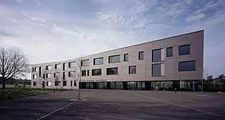
Christ's College is a Church of England secondary school that serves a large urban and rual community in the Bellfields neighbourhood of Guildford, Surrey, England.

Normandy is a civil parish of 16.37 square kilometres in the borough of Guildford in Surrey, England and the name of the largest village in that parish. Almost surrounded by its hill ranges, Normandy is in the plain west of Guildford, straddles the A323 'Aldershot Road' and is north of the narrowest part the North Downs known as the Hog's Back which carries a dual carriageway. The parish in 2011 had a population of 2,981 living in 1,310 households, has woods, a public common and four government-operated commons to the north that are an SSSI heath. Normandy has been home to a number of notable residents, including William Cobbett.

The fortifications of London are extensive and mostly well maintained, though many of the City of London's fortifications and defences were dismantled in the 17th and 18th century. Many of those that remain are tourist attractions, most notably the Tower of London.

Betsom's Hill is a hill on the North Downs, and the highest point in the county of Kent at 251 metres (823 ft). Situated between Westerham and Tatsfield, at the western edge of the county, it lies close to where the A233 crosses the Downs en route to Biggin Hill. This is the highest part of the North Downs, with Botley Hill the highest point, nearby to the west. The hill lies at the western end of the Kent Downs, an area of outstanding natural beauty.

Hazelwood School is an independent preparatory school located in Limpsfield, Surrey.
Patrick Stewart Boulter FRCS, FRCSEd was a general surgeon in Guildford, England. He developed a sub-speciality interest in breast surgery and was one of the pioneers in the UK of screening for breast cancer. He served as president of the Royal College of Surgeons of Edinburgh from 1991 to 1994.
Mindenhurst is a new neighbourhood in the village of Deepcut in Surrey, England, which is being built on the Princess Royal Barracks. It is in the London commuter belt giving families a rural lifestyle whilst being able to easily commute into the city. It will provide 1,200 new homes alongside 69 hectares of green space including woodlands. It will also have a number of amenities to support the new community.

