
Herman's Island in Nova Scotia
Herman's Island is a community in the Canadian province of Nova Scotia, located in the Lunenburg Municipal District in Lunenburg County.
Coordinates: 44°25′5.56″N64°19′5.41″W / 44.4182111°N 64.3181694°W
Herman's Island is a community in the Canadian province of Nova Scotia, located in the Lunenburg Municipal District in Lunenburg County.
Coordinates: 44°25′5.56″N64°19′5.41″W / 44.4182111°N 64.3181694°W
Mill Cove is a community in the Canadian province of Nova Scotia, located in the Chester Municipal District on the Aspotogan Peninsula on the Lighthouse Route. The community was home to CFS Mill Cove from 1967 til the 1990s.
Green Bay is a community in the Canadian province of Nova Scotia, located in the Lunenburg Municipal District in Lunenburg County.
Chelsea is a community in the Canadian province of Nova Scotia, located in the Lunenburg Municipal District in Lunenburg County, Nova Scotia. It was probably named for Chelsea, London.
Blockhouse is a community in the Canadian province of Nova Scotia, located in the Lunenburg Municipal District in Lunenburg County. It was named after the blockhouses constructed by Captain Ephraim Cook to protect colonists following a raid in 1756. The final blockhouse in the community burned down in 1874.
Simpson's Corner is a community in the Canadian province of Nova Scotia, located in the Lunenburg Municipal District in Lunenburg County.
Dayspring is a community in the Canadian province of Nova Scotia, located on the banks of the Lahave River in the Lunenburg Municipal District in Lunenburg County. It is home to the traditional wooden shipyard, Snyder's Shipyard, builders of Theodore Too, among many other vessels, as well as The Riverview Enhanced Living Centre, Miller's Point Peace Park, the Municipal Activity and Recreation Complex and the Bridgewater/Dayspring Airpark.

Martins River is a community in the Canadian province of Nova Scotia, located in the Lunenburg Municipal District in Lunenburg County. It takes its name from the river which flows through the community. A section of the Trans Canada Trail passes through the community on the former alignment of the Halifax and Southwestern Railway.
Pentz is a rural community in the Canadian province of Nova Scotia, located in the Lunenburg Municipal District in Lunenburg County.
Dublin Shore is a community in the Canadian province of Nova Scotia, located in the Lunenburg Municipal District in Lunenburg County. It takes its name from Dublin, Ireland.
Glengarry is a community in the Canadian province of Nova Scotia, located in the Lunenburg Municipal District in Lunenburg County.
Auburndale is a community in the Canadian province of Nova Scotia, located in the Lunenburg Municipal District in Lunenburg County. Located approximately 1.5 km northwest of Bridgewater, Nova Scotia, Auburndale was formerly named Branch.
Blue Rocks is a community in the Canadian province of Nova Scotia, located in the Lunenburg Municipal District in Lunenburg County. It stands to seaward of Lunenburg, Nova Scotia, somewhat to the east. For many years a fishing village, it was discovered by many artists and photographers beginning in the 1940s. Today the village boasts many artists, and there are also numerous guest houses to be found among the fishermen's dwellings.
Heckman's Island is a community in the Canadian province of Nova Scotia, located in the Lunenburg Municipal District in Lunenburg County. After Mi'kmaq fighters killed John Payzant's father and brother in the Raid on Lunenburg (1756), they were buried on Heckman's Island.
Second Peninsula is a community in the Canadian province of Nova Scotia, located in the Lunenburg Municipal District in Lunenburg County.
Stonehurst is a community in the Canadian province of Nova Scotia, located in the Lunenburg Municipal District in Lunenburg County.

The Raid on Lunenburg occurred during the French and Indian War when Mi'kmaq and Maliseet fighters attacked a British settlement at Lunenburg, Nova Scotia on May 8, 1756. The native militia raided two islands on the northern outskirts of the fortified Township of Lunenburg, Rous Island, and Payzant Island. According to French reports, the Raiding party killed twenty settlers and took five prisoners. This raid was the first of nine the Natives and Acadians would conduct against the peninsula over a three-year period during the war. The Wabanaki Confederacy took John Payzant and Lewis Payzant prisoner, both of whom left written account of their experiences.
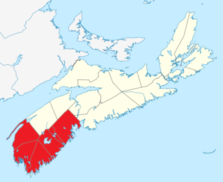
Southern Nova Scotia or the South Shore is a region of Nova Scotia, Canada. The area has no formal identity and is variously defined by geographic, county and other political boundaries. Statistics Canada, defines Southern Nova Scotia as an economic region, composed of Lunenburg County, Queens County, Shelburne County, Yarmouth County, and Digby County. According to Statistics Canada, the region had the highest decrease of population in Canada from 2009 to 2010, with a population decrease of 10.2 residents per thousand. The region also has the second-highest median age in Canada at 47.1 years old.
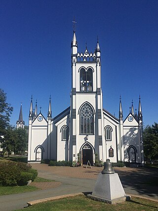
St. John's Anglican Church was the first church established in Lunenburg, Nova Scotia, Canada (1753). It is the second Church of England built in Nova Scotia, and is the second oldest continuous Protestant church in present-day Canada. Early on 1 November 2001, St. John's church suffered significant damage by fire. It was restored and re-dedicated June 12, 2005.
The Hillcrest Cemetery is the oldest protestant cemetery in Lunenburg, Nova Scotia and one of the oldest in Canada. The cemetery is adjacent to the Lunenburg Academy. The oldest marker is dated 1761, eight years after Lunenburg was established. Hillcrest Cemetery contains 5 Commonwealth war graves from World War I and one from World War II.

A township in Nova Scotia, Canada, was an early form of land division and local administration during British colonial settlement in the 18th century. They were created as a means of populating the colony with people loyal to British rule. They were typically rural or wilderness areas of around 100,000 acres (400 km2) that would eventually include several villages or towns. Some townships, but not all, returned a member to the General Assembly of Nova Scotia; others were represented by the members from the county. Townships became obsolete by 1879 by which time towns and counties had become incorporated.
| | This Lunenburg County, Nova Scotia location article is a stub. You can help Wikipedia by expanding it. |