
Venice is a residential, commercial, and recreational beachfront neighborhood within Los Angeles, California. It is located within the urban region of western Los Angeles County known as the Westside.

Hermosa Beach is a beachfront city in Los Angeles County, California, United States. Its population was 19,506 at the 2010 U.S. Census. The city is located in the South Bay region of the Greater Los Angeles area; it is one of the three Beach Cities. Hermosa Beach is bordered by the other two, Manhattan Beach to the north and Redondo Beach to the south and east.

Manhattan Beach is a city in southwestern Los Angeles County, California, United States, on the Pacific coast south of El Segundo, and north of Hermosa Beach. Manhattan Beach is one of the three Beach Cities that make up the South Bay. The climate is unusually moderate because of Manhattan Beach's proximity to the Pacific Ocean, with an average year-round high of 69.1ºF and an average year-round low of 56.4ºF. Its schools are run independently of Los Angeles Unified School District with a separate school board based in Manhattan Beach. Mira Costa High School in Manhattan Beach is ranked in the top 1% of high schools nationally and has students from both Manhattan Beach and Hermosa Beach. According to a May 18, 2017 PropertyShark study the City of Manhattan Beach 90266 zip code ranked as the 32nd most expensive zip code in the United States. According to a December 2017 PropertyShark study the City of Manhattan Beach had the highest median price per square foot for residential properties of all 88 cities in L.A. County, ahead of Malibu and Beverly Hills. The community is known for a long beach stretching approximately 2.1 miles and roughly 450 feet wide. The residents have a median age of 44.2 years, an average household size of 2.5, and 55.6% are married. Manhattan Beach is known for having less traffic congestion than other parts of Los Angeles, along with many fine dining options, and a casual beach culture.

Redondo Beach is coastal city in Los Angeles County, California, United States, located in the South Bay region of the Greater Los Angeles area. It is one of three adjacent beach cities along the southern portion of Santa Monica Bay. The population was 66,748 at the 2010 census, up from 63,261 at the 2000 census.

Playa del Rey is an affluent beachside community in the Westside of the city of Los Angeles, California. It has a ZIP code of 90293 and area codes of 310 and 424. As of 2014, the Playa del Rey population was 12,129 people. Since 2000, it has had a population growth of 14.61 percent.

Beach Cities is a nickname for a coastal area of Los Angeles County comprising oceanfront cities of Manhattan Beach, Hermosa Beach, and Redondo Beach, located on the south end of the Santa Monica Bay west and south of downtown Los Angeles, north of the Palos Verdes Peninsula on the Pacific Ocean in Southern California. Neighboring Torrance also shares a strip of beach property in the South Bay, but is generally excluded from the group.

Santa Monica Bay is a bight of the Pacific Ocean in Southern California, United States. Its boundaries are slightly ambiguous, but it is generally considered to be the part of the Pacific within an imaginary line drawn between Point Dume, in Malibu, and the Palos Verdes Peninsula. Its eastern shore forms the western boundary of the Los Angeles Westside and South Bay regions. Although it was fed by the Los Angeles River prior to the river's catastrophic change of course in 1825, the only stream of any size now flowing into it is Ballona Creek. Other waterways draining into the bay include Malibu Creek, Topanga Creek, and Santa Monica Creek.
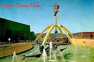
Pacific Ocean Park was a twenty-eight acre, nautical-themed amusement park built on a pier at Pier Avenue in the Ocean Park section of Santa Monica, California, which was intended to compete with Disneyland. After it closed and fell into disrepair, the park and pier anchored the Dogtown area of Santa Monica.
The history of Santa Monica, California, covers the significant events and movements in Santa Monica's past.
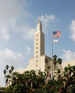
The Los Angeles California Temple, the tenth operating and the second-largest temple operated by The Church of Jesus Christ of Latter-day Saints, is on Santa Monica Boulevard in the Westwood district of Los Angeles, California, United States. When it was dedicated in 1956, it was the largest of the church's temples, though it has since been surpassed by the Salt Lake Temple due to later expansions. The temple serves 39 stakes in Los Angeles, Ventura, Kern, Santa Barbara, and San Luis Obispo counties. The grounds include a visitors' center, which was renovated in 2010, the Los Angeles Regional Family History Center, both of which are open to the public, and the headquarters of the church's California Los Angeles Mission.

The Marvin Braude Bike Trail, also known as The Strand, is a paved bicycle path that runs mostly along the Pacific Ocean shoreline in Los Angeles County, California. The northern terminus of the trail is a paved Class 1 bicycle path at Will Rogers State Beach in Pacific Palisades, Los Angeles. The southern terminus of the trail is in Torrance County Beach in Torrance. The path is 22 miles long, and the midpoint between the two ends of the path is near the southern end of the Playa del Rey residential area.
The Long Beach Museum of Art is a museum located on Ocean Boulevard in the Bluff Park neighborhood of Long Beach, California, United States.

Fisherman's Village is a waterfront mall, commercial boat anchorage and tourist attraction located in the world's largest man-made small boat harbor in Marina del Rey, California. It is nestled on the eastern bank of main channel between Shanghai Red's restaurant to the south and the Windward boatyard to the north.

The Huntington Beach Pier is a municipal pier located in Huntington Beach, California, at the west end of Main Street and west of Pacific Coast Highway. At 1,850 feet (560 m) in length, it is one of the longest public piers on the West Coast.. The deck of the pier is 30 feet (9.1 m) above sea level, while the top of the restaurant structure at the end of the pier is 77 feet (23 m).
The Pike was an amusement zone in Long Beach, California. The Pike was founded in 1902 along the shoreline south of Ocean Boulevard with several independent arcades, food stands, gift shops, a variety of rides and a grand bath house. It was most noted for the Cyclone Racer (1930–1968), a large wooden dual-track roller coaster, built out on pilings over the water.

Pier Village is a Victorian-inspired mixed-use community located in Long Branch, New Jersey along the Atlantic Ocean. It opened in 2005.

The Redondo Beach pier is located in Redondo Beach, California and stretches out into the Pacific Ocean. The pier has been rebuilt and altered by storms and redevelopments. Its official name is "Municipal Pier," and it has also been called the "Endless Pier." Earlier versions were known as "Pleasure Pier" and "Horseshoe Pier."

Cabrillo Beach is a historic beach located in San Pedro, Los Angeles, California. It is named after Juan Rodríguez Cabrillo, a Portuguese explorer who was the first to sail up the California coast. Cabrillo has two separate beach areas.
Alamitos Beach is a coastal neighborhood in the southern portion of the city of Long Beach, California. Although it was in unincorporated Los Angeles County when annexed by the City of Long Beach, it had been planned as its own community with a townsite.

The Long Wharf in Santa Monica, also known as Port Los Angeles or the Mile Long Pier, was an extensive pier wharf constructed by the Southern Pacific Railroad Company in Santa Monica Bay from 1892–94. When it opened in 1894, it was the longest wharf in the world, measuring approximately 4,700 feet. It served as a cargo and passenger port until 1913, and in 1919 removal of the wharf started. The wharf, the 1000 foot tip of the pier, was removed by 1920. The remaining 3,600 feet of pier was used as a run down fishing pier until 1933, when the remainder of the pier was removed. One of the major imports to the wharf was lumber from Northern ports, to help in the construction boom in Southern California. Southern Pacific Railroad and the street cars of the Los Angeles Pacific Railroad served the wharf. Los Angeles Pacific Railroad ran passenger trams to the wharf and from midnight to sunrise ran cargo cars.


