History
14th-19th century
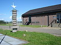
There was a settlement near the Meuse in this area in the 14th century, a hamlet between Alem and Gewande [ nl ].
At the end of the 18th century and in 1850, Het Wild had ten houses.
20th century
By 1930 the hamlet had 23 houses, as well as a café which also served as the telephony and telegraphy station. For the church, school, and post office, locals had to travel to Alem, which at the time was still situated on the left bank of the Meuse.
During the Second World War, Het Wild was almost entirely razed. On 3 October 1944, the German SS gave the order for inhabitants of the village to leave with their possessions. The village was then burnt. On their return after the liberation, the villagers built a town again, a short distance from the suburbs. The new design was characteristic of the Delft school.
The area falls under the parish of Alem up to the point of the canalisation of the Meuse where Alem meets the bank. Then, the inhabitants go to church and to school in Maren-Kessel [ nl ].
Until 1958, the hamlet was part of the former commune of Alem, Maren en Kessel. In 1958, this commune ceased to exist, and the land of the left bank of the Meuse, including Het Wild, became part of the commune of Lith.
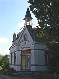
The mouth of the Hertogswetering and the pumping station of Gewande are located in Het Wild. The former mouth and the former Hertogsgemaal pumping station are a short distance away in Gewande [ nl ], 's-Hertogenbosch.
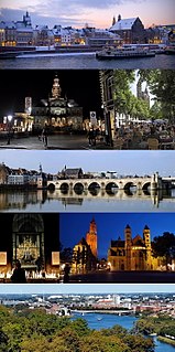
Maastricht is a city and a municipality in the southeastern Netherlands. It is the capital and largest city of the province of Limburg. Maastricht is located on both sides of the Meuse, at the point where the Jeker joins it. Mount Saint Peter (Sint-Pietersberg) is largely situated within the city's municipal borders. Maastricht is adjacent to the border with Belgium. It is part of the Meuse-Rhine Euroregion, a metropolis with a population of about 3.9 million, which includes the nearby German and Belgian cities of Aachen, Liège and Hasselt.

Eijsden is a village situated in the very south of the European country the Netherlands. It is located in the southeastern part of the province of Limburg.

Roermond is a city, a municipality, and a diocese in the southeastern part of the Netherlands. Roermond is a historically important town on the lower Roer at the east bank of the river Meuse. In 1231 it received town rights. Roermond's town centre has become a designated conservation area.

Buren is a town and municipality in the Betuwe region of the Netherlands. Buren has 27.168 inhabitants as of 1 January 2022.

Lith is a village in the province North Brabant in the Netherlands. Before 2011, there was also a municipality; since 2011 Lith is a part of Oss.

Sint-Oedenrode is a town in the province of North Brabant.

Rozenburg is a town and former municipality in the western Netherlands, in the province of South Holland. The municipality had a population of 13,173 in 2004, and covers an area of 6.50 km². It was the second-smallest municipality in the Netherlands in area. On 10 July 2008, the local council decided to disband the municipality and to form a submunicipality of Rotterdam. This was ratified on 27 October 2008 by the Eerste Kamer, and came into effect on 18 March 2010.

Maldegem, earlier spelled Maldeghem, is a municipality located in the Belgian province of East Flanders. The municipality comprises the villages of Maldegem, Adegem and Middelburg. Kleit and Donk have always been separate hamlets of Maldegem. On January 1, 2018, Maldegem had a total population of 23,689. The total area is 94.64 square kilometres (36.54 sq mi) which gives a population density of 250 inhabitants per km².
Buitenpost is a village in north-east Friesland in the Netherlands.

Puttershoek is a town and former municipality in the western Netherlands. It is located on the banks of the Oude Maas, on the island Hoeksche Waard, in the province of South Holland. On January 1, 1984, the municipality of Puttershoek was merged with several others into Binnenmaas. With 6,293 inhabitants Puttershoek was the largest settlement in the municipality of Binnenmaas until 's-Gravendeel joined Binnenmaas in 2007. Since 1 January 2019, it is part of the new municipality Hoeksche Waard.
Balgoij or Balgoy is a village in Gelderland, Netherlands, near the river Meuse. It belongs to the Wijchen municipality.

Alem is a village in the Dutch province of Gelderland. It is a part of the municipality of Maasdriel, and lies about 10 km north of 's-Hertogenbosch.

Alphen is a village in the Dutch province of Gelderland. It is a part of the municipality of West Maas en Waal, and lies about 7 km north of Oss.

Echt is a city in the Dutch municipality of Echt-Susteren in the province of Limburg, Netherlands. It was a municipality itself until it merged with the municipality of Susteren on January 1, 2003.

Kessel is a village in the southern Netherlands. It is located in Oss, North Brabant about 12 km northeast of 's-Hertogenbosch on the river Maas.
Maren is a village in the Dutch province of North Brabant. It is located in the municipality of Oss, about 10 km northeast of 's-Hertogenbosch.

Sint-Michielsgestel is a village in the municipality of Sint-Michielsgestel, Netherlands.

Cuijk is a town in the northeastern part of the province of North Brabant, Netherlands. It is the successor of a Roman settlement on the west bank of the Meuse, 13 km south of Nijmegen. Cuijk, which had a population of 18,170 as of 2020, was the centre of an eponymous municipality, which ceased to exist on 1 January 2022, when it was replaced by the larger Land van Cuijk municipality.

Wehe-Den Hoorn is a village in the Dutch province of Groningen. It is part of the municipality of Het Hogeland. It is a 1966 merger of the villages of Wehe and Den Hoorn.

Moordhuizen is a hamlet in the Dutch province of Gelderland. It is a part of the municipality of West Maas en Waal and is located about 3 kilometres (1.9 mi) from Alphen. The hamlet is notable for its name, and is the location of the Quarles van Ufford pumping station.
This page is based on this
Wikipedia article Text is available under the
CC BY-SA 4.0 license; additional terms may apply.
Images, videos and audio are available under their respective licenses.