
A hillfort is a type of earthwork used as a fortified refuge or defended settlement, located to exploit a rise in elevation for defensive advantage. They are typically European and of the Bronze Age or Iron Age. Some were used in the post-Roman period. The fortification usually follows the contours of a hill and consists of one or more lines of earthworks, with stockades or defensive walls, and external ditches.

The Urnfield culture was a late Bronze Age culture of Central Europe, often divided into several local cultures within a broader Urnfield tradition. The name comes from the custom of cremating the dead and placing their ashes in urns, which were then buried in fields. The first usage of the name occurred in publications over grave sites in southern Germany in the late 19th century. Over much of Europe, the Urnfield culture followed the Tumulus culture and was succeeded by the Hallstatt culture. Some linguists and archaeologists have associated this culture with the pre-Celtic language, or a Proto-Celtic language family.
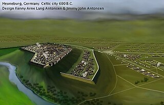
The Heuneburg is a prehistoric hillfort by the river Danube in Hundersingen near Herbertingen, between Ulm and Sigmaringen, Baden-Württemberg, in the south of Germany, close to the modern borders with Switzerland and Austria. It is considered to be one of the most important early Celtic centres in Central Europe, particularly during the Iron Age Hallstatt culture period. Apart from the fortified citadel, there are extensive remains of settlements and burial areas spanning several centuries.

Eastgate is a permanently open gate through the Chester city walls, on the site of the original entrance to the Roman fortress of Deva Victrix in Chester, Cheshire, England. It is a prominent landmark in the city of Chester and the Eastgate clock on top of it is said to be the most photographed clock in England after Big Ben.

Pen Dinas is the name of a large hill within the boundary of the village of Penparcau, on the coast of Ceredigion, Wales, upon which an extensive Iron Age, Celtic hillfort of international significance is situated. The site can easily be reached on foot from Aberystwyth town center and is accessible via a series of well marked trails. Boasting a commanding position at the confluence of the River Ystwyth and Afon Rheidol, it has been described as "the pre-eminent hillfort on the Cardigan Bay coast".

Pevensey Castle is a medieval castle and former Roman Saxon Shore fort at Pevensey in the English county of East Sussex. The site is a scheduled monument in the care of English Heritage and is open to visitors. Built around 290 AD and known to the Romans as Anderitum, the fort appears to have been the base for a fleet called the Classis Anderidaensis. The reasons for its construction are unclear; long thought to have been part of a Roman defensive system to guard the British and Gallic coasts against Saxon pirates, it has more recently been suggested that Anderitum and the other Saxon Shore forts were built by a usurper in an ultimately unsuccessful attempt to prevent Rome from reimposing its control over Britain.
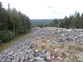
The Celtic hill fort of Otzenhausen is one of the biggest fortifications the Celts ever constructed. It was built by Gauls of the Treveri tribe, who lived in the region north of the fort. The fort is located on top of the Dollberg, a hill near Otzenhausen in Germany, about 695 m above sea level. The only visible remains are two circular earth ramparts, covered with stones.

The Vallum is a huge earthwork associated with Hadrian's Wall in England. Unique on any Roman frontier, it runs practically from coast to coast to the south of the wall.
Stockport Castle was a promontory castle in Stockport, Cheshire. The castle was in the medieval town, overlooking a ford over the River Mersey. It was first documented in 1173, but the next mention of it is in 1535 when it was in ruins. What remained of the castle was demolished in 1775.

Molavėnai is a small village in the Raseiniai district municipality, Lithuania.

The Moesian Limes is the modern term given to a collection of Roman fortifications between the Black Sea shore and Pannonia, present-day Hungary, consisting primarily of forts along the Danube to protect the Roman provinces of Upper and Lower Moesia south of the river.
Mellor hill fort is a prehistoric site in North West England, that dates from the British Iron Age—about 800 BC to 100 AD. Situated on a hill in Mellor, Greater Manchester, on the western edge of the Peak District, the hill fort overlooks the Cheshire Plain. Although the settlement was founded during the Iron Age, evidence exists of activity on the site as far back as 8,000 BC; during the Bronze Age the hill may have been an area where funerary practices were performed. Artefacts such as a Bronze Age amber necklace indicate the site was high status and that its residents took part in long-distance trade. The settlement was occupied into the Roman period. After the site was abandoned, probably in the 4th century, it was forgotten until its rediscovery in the 1990s.

Buckland Rings is the site of an Iron Age hill fort in the town of Lymington, Hampshire. Today, the mounds and dykes around the outside which once constituted its defences are still clearly visible, although the outer bank lies under the road on the west side, and on the south-east it is nearly ploughed-out. Excavations of the inner and middle ramparts in 1935 revealed that they were of wall-and-fill construction, retained at the front by upright timber beams and walls of cut and laid turf. The entrance, which lies on the east side, was also excavated revealing a long entrance passage and the postholes for a pair of stout gateposts. The site was bought by Hampshire County Council in 1989 to ensure its preservation, and it is open to the public from the A337 road onto which part of it faces.

Blewburton Hill is the site of an Iron Age hillfort located in Oxfordshire, in the southeast of England. It was a univallate hillfort. The area is mostly farmland with some small areas of wooded copse to the south and the northeast. The hill fort may have been occupied from the 4th century BC to the 1st century BC, and replaced a small settlement surrounded by a stockade, which is estimated to have been built in the 5th or 6th century BC.
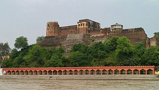
Akhnoor Fort is a fort on the right bank of the Chenab River, 28 km from Jammu City.

The ruins of Sayn Castle, the 12th century family castle of the counts of Sayn and Sayn-Wittgenstein, are in Sayn, part of the borough of Bendorf on the Rhine, between Koblenz and Neuwied in the county of Mayen-Koblenz in the German state of Rhineland-Palatinate.

The Bulwarks, Porthkerry is a promontory fort in Rhoose, Vale of Glamorgan, on the southern coast of Wales overlooking the Bristol Channel. It probably dates to the Iron Age and continued to be occupied during the Roman period in Britain. The ramparts and ditches along the west side are well preserved, but the fortifications are heavily overgrown.

The burgstall of Schlossberg Castle, also called the Burgstall on the Flöss or the Heidenstein, is a now levelled, probably high mediaeval, nobleman's castle. It is situated above Haidhof, a village in the municipality of Gräfenberg in the Upper Franconian county of Forchheim in the south German state of Bavaria.

Zyndram’s Hill is an archaeological site located in southern Poland, in Maszkowice village, Łącko commune. It was a prehistoric defensive settlement occupied in the Early Bronze Age, in the Late Bronze Age and Early Iron Age and in the La Tène Period.

The Castra Alteium is a former late-Roman border fort on the Danube-Iller-Rhine Limes (DIRL). It is located in the territory of the city of Alzey in Rhenish Hesse, Germany. The fort was presumably built in the course of the last reconstruction measures on the Rhine frontier between 367 and 370 AD under the western Emperor Valentinian I. Previously, there was a Roman civilian settlement (Vicus), Altiaia, which was devastated by Alamanni in 352–353. The fort was also destroyed twice, and probably abandoned at the end of the fifth century.


