
South Africa occupies the southern tip of Africa, its coastline stretching more than 2,850 kilometres from the desert border with Namibia on the Atlantic (western) coast southwards around the tip of Africa and then northeast to the border with Mozambique on the Indian (eastern) coast. The low-lying coastal zone is narrow for much of that distance, soon giving way to a mountainous escarpment that separates the coast from the high inland plateau. In some places, notably the province of KwaZulu-Natal in the east, a greater distance separates the coast from the escarpment. Although much of the country is classified as semi-arid, it has considerable variation in climate as well as topography. The total land area is 1,220,813 km2 (471,359 sq mi). It has the 23rd largest Exclusive Economic Zone of 1,535,538 km2 (592,875 sq mi).

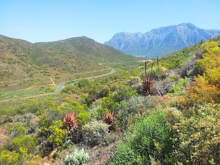
Fynbos is a small belt of natural shrubland or heathland vegetation located in the Western Cape and Eastern Cape provinces of South Africa. This area is predominantly coastal and mountainous, with a Mediterranean climate and rainy winters. The fynbos ecoregion is within the Mediterranean forests, woodlands, and scrub biome. In fields related to biogeography, fynbos is known for its exceptional degree of biodiversity and endemism, consisting of about 80% species of the Cape floral kingdom, where nearly 6,000 of them are endemic. This land continues to face severe human-caused threats, but due to the many economic uses of the fynbos, conservation efforts are being made to help restore it.

Breede Valley Municipality is a local municipality located within the Cape Winelands District Municipality, in the Western Cape province of South Africa. As of 2007, it had a population of 166,825. Its municipality code is WC025.

The Breede River, also known as Breë River, is a river in the Western Cape Province of South Africa. Travelling inland north from the city of Cape Town, the river runs in a west to east direction. The surrounding western mountains formed the first continental divide experienced by European settlers in the 18th century. The Titus River and Dwars River become the Breë River.

Worcester is a town in the Western Cape, South Africa. It is the third-largest city in the Western Cape Province of South Africa. It is located 120 kilometres (75 mi) north-east of Cape Town on the N1 highway north to Johannesburg.
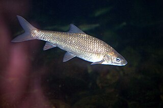
The Cape whitefish or Berg-breede River whitefish is a ray-finned fish species in the family Cyprinidae. It was formerly placed with the South African redfins in Pseudobarbus. It is tetraploid. Its closest living relative is the sawfin.
Breede River Valley is a region of Western Cape Province, South Africa known for being the largest fruit and wine producing valley in the Western Cape, as well as South Africa's leading race-horse breeding area. It is part of the Boland bordering on becoming Little Karoo towards the east.

The wine regions of South Africa were defined under the "Wine of Origin" act of 1973. Mirroring the French Appellation d'origine contrôlée (AOC) system, all South African wines listing a "Wine of Origin" must be composed entirely of grapes from its region. The "Wine of Origins" (WO) program mandates how wine regions of South Africa are defined and can appear on wine labels. While some aspects of the WO are taken from the AOC, the WO is primarily concerned with accuracy in labeling. As a result, the WO does not place adjunct regulations on wine regions such as delineating permitted varieties, trellising methods, irrigation techniques, and crop yields.

Salmon Falls Creek is a tributary of the Snake River, flowing from northern Nevada into Idaho in the United States. Formed in high mountains at the northern edge of the Great Basin, Salmon Falls Creek flows northwards 121 miles (195 km), draining an arid and mountainous basin of 2,103 square miles (5,450 km2). The Salmon Falls Creek valley served as a trade route between the Native American groups of the Snake River Plain and Great Basin. Today, most of its water is used for irrigation.
The Western Cape Water Supply System (WCWSS) is a complex water supply system in the Western Cape region of South Africa, comprising an inter-linked system of six main dams, pipelines, tunnels and distribution networks, and a number of minor dams, some owned and operated by the Department of Water and Sanitation and some by the City of Cape Town.

The Berg River Dam is a 68-metre (223 ft) high dam on the Berg River in South Africa. It is the centerpiece of the Berg Water Project (BWP) which is designed to capture the winter rainfall and store it for supply to Cape Town during the dry summer months. The project in turn forms an important part of the Western Cape Water Supply System (WCWSS), an intricate system of dams and bulk water infrastructure that provides water to more than 3 million people. At the inauguration of the dam in 2009, then President of South Africa Kgalema Motlanthe called the project "a good example of how public infrastructure projects can be used to contribute meaningfully to poverty eradication and to foster social empowerment of the people." The Berg River Dam was the first dam in South Africa to be designed and constructed in accordance with the guidelines of the World Commission on Dams. It has been completed on time and within budget. The Berg River basin and the adjacent metropolitan area of Cape Town are of particular importance to the Western Cape region because, although the basin generates only about 3% of the country's water resources, it is home to about 8% of South Africa's population, and produces about 12% of GDP.
Greater Brandvlei Dam is an earth-fill type dam located on a tributary of the Breede River, near Worcester, Western Cape, South Africa. It was formed by joining the original Brandvlei Dam and the Kwaggaskloof Dam after reconstruction in 1989. Its main purpose is for irrigation use and the hazard potential of the dam has been ranked high (3).

Touws River is a small railway town of 8,126 people in the Western Cape province of South Africa. It is located on the river of the same name, about 160 kilometres (100 mi) north-east of Cape Town. The Touwsrivier CPV Solar Project is located just outside of the town and supplies 50 MW to the national electrical grid.

The Groot River is a river in the southern area of the Western Cape province of South Africa. It is a right hand tributary of the Gourits River.
The Karoo Desert National Botanical Garden is a botanical garden focused on succulents and other plants of arid regions, that lies at the foot of the Hex River Mountains range, in the town of Worcester, South Africa.
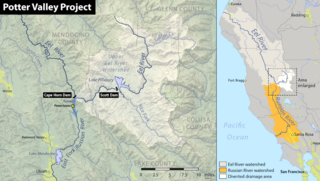
The Potter Valley Project is an interbasin water transfer project in Northern California in the United States, delivering water from the Eel River basin to turbines in the headwaters of the Russian River. The project is owned and operated by Pacific Gas and Electric Company (PG&E). The main facilities are two dams on the Eel River, a diversion tunnel and hydroelectric plant. Average annual throughput is 159,000 acre⋅ft (196,000,000 m3), although this figure varies significantly with both the amount of precipitation in the Eel River basin and the demand on the Russian River.
Robertson Karoo is a semi-arid vegetation type, restricted to sections of the Breede River Valley, Western Cape Province, South Africa. It is a subtype of Succulent Karoo and is characterised by the dominance of succulent plant species, and by several endemic plants and animals.
The Cape Winelands Biosphere Reserve is located in the Western Cape Province of South Africa approximately 40 km (25 mi) east of Cape Town. The Biosphere Reserve extends from the Kogelberg Biosphere Reserve in the south, northwards along the Cape Fold Belt Mountain Chain and the adjoining valleys constituting the Cape Winelands. The Biosphere Reserve incorporates key portions of the registered Cape Floral Region Protected Areas World Heritage Site. The Reserve was designated in 2007.
The Kammanassie Mountains are a mountain range in the Western Cape, South Africa. The highest peak is Mannetjiesberg at 1,955 metres above sea level and the mountain range is one of the prominent east-west trending ranges composing the southern branch of the Cape Fold Belt.
The Klein Berg River is a major right-hand tributary of the Berg River in the Western Cape province of South Africa. The Klein Berg drains the Tulbagh basin through the Nuwekloof into the Swartland, where it joins the Berg.
