The Buccaneer Archipelago is a group of islands off the coast of Western Australia near the town of Derby in the Kimberley region. The closest inhabited place is Bardi located about 54 kilometres (34 mi) from the western end of the island group.

The Wunaamin Miliwundi Ranges are a range of hills in the western Kimberley region of Western Australia.

The Horizontal Falls, or Horizontal Waterfalls, nicknamed the "Horries" and known as Garaanngaddim by the local Indigenous people, are an unusual natural phenomenon on the coast of the Kimberley region in Western Australia, where tidal flows cause waterfalls on the ebb and flow of each tide. The Lalang-garram / Horizontal Falls Marine Park is a protected area covering the falls and wider area.
Cape Leveque is at the northernmost tip of the Dampier Peninsula in the Kimberley region of Western Australia. Cape Leveque is 240 kilometres (150 mi) north of Broome, and is remote with few facilities. Nevertheless, the Cape's sandy beaches are attracting an increasing number of visitors.
Koolan Island is an island off the Kimberley coast of Western Australia in the Buccaneer Archipelago. It is about 1,900 km north of Perth, and about 130 km (81 mi) north of Derby. It hosts deposits of high-grade iron ore.
Port Lihou Island or Yeta is an island in the Torres Strait, in Queensland's north between the Australian mainland and Papua New Guinea. It lies off the south coast of Muralag, separated by a channel that is three kilometres long but only a few metres wide at the north-eastern end. It is approximately 2.8 by 2.8 km in size. The area is 3.97 square kilometres.

Mitchell River National Park is a national park in the Kimberley region of Western Australia, 2,140 kilometres (1,330 mi) northeast of Perth. The park adjoins the northern boundary of the Prince Regent National Park. The nearest towns are Derby, 350 kilometres (217 mi) to the southwest, as well as Wyndham, 270 km (168 mi) to the southeast. Created in 2000, the park covers an area of over 1,150 km2 (440 sq mi) on the Mitchell Plateau (Ngauwudu).

Camden Sound is a relatively wide body of water in the Indian Ocean located in the Kimberley region of Western Australia. The Sound is bounded by the Bonaparte Archipelago to the north-east, the Buccaneer Archipelago to the south-west, and Montgomery Reef to the south.

The King George River is a perennial river located in the Kimberley region of Western Australia.
Bigge Island is an island off the coast of the Kimberley region in Western Australia, within the Shire of Wyndham-East Kimberley.

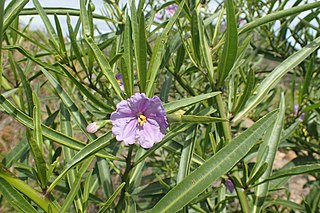
Solanum chippendalei is a small fruiting shrub in the family Solanaceae, native to northern Australia. It is named after its discoverer, George Chippendale. The fruits, known as "bush tomatoes", are edible and are an important indigenous food, and the aborigines who use them broadcast the seed for later harvesting.

Prince Regent National Park, formerly the Prince Regent Nature Reserve, is a protected area in the Kimberley region of Western Australia. In 1978 the area was nominated as a UNESCO World Biosphere Reserve.
The Islands of the Kimberley are a group of over 2,500 islands lying off the coast of the Kimberley region of Western Australia. The islands extend from the Western Australia–Northern Territory border in the east to just north of Broome in the west.
Coronation Island, also known as Garlinju, is located off the Kimberley coast of Western Australia. It encompasses an area of 3,817 hectares. It is located off Port Nelson in the Bonaparte Archipelago, as a part of the group of islands known as the Coronation Islands, which were named by Philip Parker King, the first European to visit the islands in 1820, after the anniversary of the coronation of George III, who had died in January of that year.
Niiwalarra, formerly known as Sir Graham Moore Island, is located off the Kimberley coast of Western Australia.
South West Osborn Island is an island off the coast of the Kimberley region in Western Australia.
Champagny Island, known to the traditional owners as Nimenba, is an island off the coast of the Kimberley region in Western Australia.
The Yawijibaya, also written Jaudjibaia, are an Aboriginal Australian people of the Kimberley region of northern Western Australia. Along with the Unggarranggu people, they are the traditional owners of the Buccaneer Archipelago, off Derby, together known as the Mayala group for native title purposes. Yawijibaya country includes Yawajaba Island and the surrounding Montgomery Reef.

Solanum esuriale is a species of perennial herbaceous plant native to Australia.
Solanum symonii is a species of flowering plant in the family Solanaceae and is native to near-coastal areas of Western Australia and South Australia. It is an erect shrub with egg-shaped to lance-shaped leaves and pale lavender-purple flowers.