DeWitt is a town (township) in Onondaga County, New York, USA. As of the 2010 census, the town's population was 25,838. The town is named after Major Moses DeWitt, a judge and soldier. An eastern suburb of Syracuse, DeWitt also is "the site of most of the campus and all of the academic buildings of Le Moyne College".
East Syracuse is an incorporated village and a suburb of the City of Syracuse in eastern Onondaga County, New York. United States. As of the 2010 U.S. census, the village had a population of 3,084. It is located immediately east of Syracuse, in the town of DeWitt.

Fayetteville is a village located in Onondaga County, New York, United States. As of the 2010 U.S. Census, the village had a population of 4,373. The village is named after the Marquis de Lafayette, a national hero of both France and the United States. It is part of the Syracuse Metropolitan Statistical Area.

Manlius is a village in Onondaga County, New York, United States. The population was 4,704 at the 2010 census. The village is located near the southern boundary of the town of Manlius and is a southeast suburb of the city of Syracuse. An area of about three blocks within the village, running along Seneca Street and parallel to Pleasant Street, is listed on the National Register of Historic Places as the Manlius Village Historic District.

Highbridge is a residential neighborhood geographically located in the central-west section of the Bronx, New York City. Its boundaries, starting from the north and moving clockwise are the Cross-Bronx Expressway to the north, Grand Concourse to the east, East 161st Street to the south, and the Harlem River to the west. Ogden Avenue is the primary thoroughfare through Highbridge.

New York State Route 48 (NY 48) is a 28.20-mile (45.38 km) north–south state highway in Central New York in the United States. The southern terminus of the route is located at Interstate 690 (I-690) exit 3 near the interchange between I-690 and the New York State Thruway (I-90) in Van Buren, northwest of Syracuse. The northern terminus is located at an intersection with NY 104 in Oswego. In between, NY 48 passes through the riverside communities of Baldwinsville and Fulton and runs alongside both the Seneca River and Oswego River. For most of its route, NY 48 serves as an alternate route of NY 481. The routes share similar alignments along the Oswego River from the Syracuse area to Oswego, with NY 481 following the eastern riverbank between the two locations.
New York State Route 297 (NY 297) is a state highway in the western suburbs of Syracuse, New York, in the United States. It is signed as north–south; however, it follows more of a southwest–northeast alignment for 2.33 miles (3.75 km) through the towns of Camillus and Geddes. The southern terminus of the route is at an intersection with NY 173 in a section of Camillus known as Fairmount. Its northern terminus is at a junction with State Fair Boulevard in Geddes, where NY 297 connects to Interstate 690 (I-690) exit 7. NY 297 passes through the northern portion of the village of Solvay and runs adjacent to the New York State Fairgrounds north of Solvay. The route was assigned in the late 1950s.

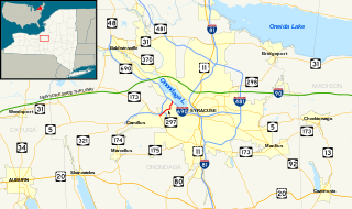
New York State Route 298 (NY 298) is an east–west state highway located entirely within Onondaga County, New York, in the United States. It runs in a generally northeast direction for 14.05 miles (22.61 km) from an interchange with Interstate 690 (I-690) in the city of Syracuse to an intersection with NY 31 near the shores of Oneida Lake. Along its course it has exits with all four Interstate Highways in the area. Most of NY 298 was originally designated as part of NY 91 in 1930 before gaining its current designation later in the decade.
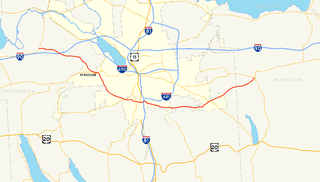
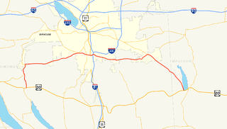
New York State Route 173 (NY 173) is a state highway located in the Syracuse area of central New York in the United States. It takes a slightly bow-shaped route from NY 31 in the town of Van Buren to NY 5 in Chittenango, gently curving to the south of Downtown Syracuse in the center of its 30.59-mile (49.23 km) routing. Even so, NY 173 briefly enters the Syracuse city limits near where it intersects U.S. Route 11 (US 11). NY 173 passes through several suburbs of Syracuse, including Camillus, where it first meets NY 5, and Manlius, where it has a short overlap with NY 92.
New York State Route 290 (NY 290) is a state highway located entirely within Onondaga County, New York, extending from downtown Syracuse to the east side of the county. It provides access to Green Lakes State Park from the north.

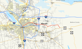
New York State Route 92 (NY 92) is a state highway located in central New York in the United States. The western terminus of the route is at an intersection with U.S. Route 11 in downtown Syracuse. Its eastern terminus is at a junction with US 20 west of the village of Cazenovia. NY 92 is known as East Genesee Street through Syracuse and DeWitt; from DeWitt to Cazenovia, its name varies by location. It heads generally eastward through Syracuse to DeWitt, where it crosses Interstate 481 (I-481) while concurrent with NY 5. At the east end of the overlap, it splits off follows a more southeasterly routing through the village of Manlius to Cazenovia.
New York State Route 174 (NY 174) is a state highway in Onondaga County, located in Central New York, in the United States. The highway is 16.7 miles (26.9 km) long and passes through mostly rural regions. Route 174 begins at an intersection with NY 41 in Borodino, a hamlet of Spafford. It heads generally northward for most of its length, except for short distances in the villages of Marcellus and Camillus. The route ends at a junction with NY 5 west of Camillus, at the west end of the Route 5 Camillus bypass. Route 174 is located along a large mapped sedimentary bedrock unit, known as the Marcellus Formation. The formation is named for an outcrop found near the town of Marcellus, New York, during a geological survey in 1839.
New York State Route 175 (NY 175) is a west–east state highway located in Onondaga County, New York, in the United States. The 15.46-mile (24.88 km) route begins at an intersection with U.S. Route 20 (US 20) east of the village of Skaneateles and passes through the village of Marcellus before ending at a junction with US 11 in Syracuse. The highway was designated in the 1930 renumbering of state highways in New York.
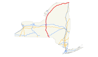
U.S. Route 11 (US 11) is a part of the U.S. Highway System that runs from New Orleans, Louisiana, to the Canada–US border at Rouses Point, New York. In the state of New York, US 11 extends for 318.66 miles (512.83 km) from the Pennsylvania state line south of the Southern Tier city of Binghamton to the Canada–US border at the North Country village of Rouses Point, where it becomes Route 223 upon entering Quebec. The portion of US 11 south of Watertown follows a mostly north–south alignment and is paralleled by Interstate 81 (I-81) while the part of the route north of Watertown follows a more east–west routing, parallel to but not directly on the St. Lawrence River.

New York State Route 114 (NY 114) is a state highway on the far eastern sections of Long Island in New York in the United States. It serves as a connector between the two "forks" of Long Island, crossing Shelter Island in the process. This is the only connection between the North and South forks east of Riverhead. NY 114 is the easternmost signed north–south state route in all of New York. Additionally, the route is the last in a series of sequential state routes on Long Island. The series begins with NY 101 in western Nassau County and progresses eastward to NY 114.
Interstate 81 (I-81) is a part of the Interstate Highway System that runs from Interstate 40 at Dandridge, Tennessee, to the Thousand Islands International Bridge at Wellesley Island in New York, beyond which a short stub links it to Ontario Highway 401. In the U.S. state of New York, I-81 extends 183.62 miles (295.51 km) from the Pennsylvania state line southeast of Binghamton to the Canadian border at Wellesley Island northwest of Alexandria Bay. The freeway runs north–south through Central New York, serving the cities of Binghamton, Syracuse, and Watertown. It passes through the Thousand Islands in its final miles and crosses two bridges, both part of the series of bridges known as the Thousand Islands Bridge.

The East Syracuse Minoa Central School District (ESM) is a pre-K through 12th grade public school district with its headquarters in Manlius, New York, enrolling approximately 3,500 students. ESM serves portions of the towns of DeWitt and Manlius, specifically the villages of East Syracuse, Minoa, and Kirkville as well as portions of Eastwood, Fayetteville, and Bridgeport. The district is partially funded by and governed under the authority of the New York State Education Department, whose standardized examinations are designed and administered by the Board of Regents of the University of the State of New York.

New York State Route 20SY (NY 20SY) was a state highway in the vicinity of Syracuse, New York, in the United States. It connected U.S. Route 20 (US 20) to downtown Syracuse via Skaneateles, Camillus, Manlius, and Cazenovia in Onondaga County and Madison County. The highway began at an intersection with US 20 and NY 321 in the village of Skaneateles and ended at a junction with US 20, NY 20N, and NY 92 near the village of Cazenovia. Most of NY 20SY overlapped another route; however, two sections of NY 20SY—one in the town of Camillus and another near the village of Fayetteville—were not concurrent with another highway.
New York State Route 20N (NY 20N) was a state highway in central New York in the United States. It was an alternate route of U.S. Route 20 (US 20) that stretched for 30.5 miles (49.1 km) between Marcellus and Cazenovia. The road began at its parent route, US 20, and NY 174 in Marcellus and ended at US 20, NY 20SY, and NY 92 in Cazenovia. All of NY 20N was concurrent with at least one other route, namely NY 174 in Marcellus, NY 175 from Marcellus to Onondaga Hill, NY 173 from Onondaga Hill to Manlius, and NY 92 and NY 20SY between Manlius and Cazenovia. NY 20N was assigned in May 1937 and removed in 1961 along with NY 20SY.