
Hoover Dam is a concrete arch-gravity dam in the Black Canyon of the Colorado River, on the border between the U.S. states of Nevada and Arizona. It was constructed between 1931 and 1936 during the Great Depression and was dedicated on September 30, 1935, by President Franklin D. Roosevelt. Its construction was the result of a massive effort involving thousands of workers, and cost over one hundred lives. Originally known as Boulder Dam from 1933, it was officially renamed Hoover Dam for President Herbert Hoover by a joint resolution of Congress in 1947.
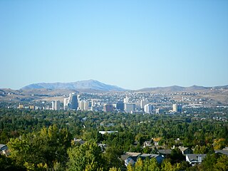
Reno is a city in the northwest section of the U.S. state of Nevada, about 22 miles (35 km) from Lake Tahoe, known as "The Biggest Little City in the World". Known for its casino and tourism industry, Reno is the county seat and largest city of Washoe County and sits in a high desert river valley at the foot of the Sierra Nevada. Its downtown area occupies a valley informally known as the Truckee Meadows, which because of large-scale investments from Greater Seattle and San Francisco Bay Area companies such as Amazon, Tesla, Panasonic, Microsoft, Apple, and Google has become a new major technology hub in the United States. The city is named after Union Major General Jesse L. Reno, who was killed in action during the American Civil War at the Battle of South Mountain on Fox's Gap.

Yosemite National Park is an American national park in the western Sierra Nevada of Central California, bounded on the southeast by Sierra National Forest and on the northwest by Stanislaus National Forest. The park is managed by the National Park Service and covers an area of 748,436 acres and sits in four counties: centered in Tuolumne and Mariposa, extending north and east to Mono and south to Madera County. Designated a World Heritage Site in 1984, Yosemite is internationally recognized for its granite cliffs, waterfalls, clear streams, giant sequoia groves, lakes, mountains, meadows, glaciers, and biological diversity. Almost 95% of the park is designated wilderness.

The Sierra Nevada is a mountain range in the Western United States, between the Central Valley of California and the Great Basin. The vast majority of the range lies in the state of California, although the Carson Range spur lies primarily in Nevada. The Sierra Nevada is part of the American Cordillera, an almost continuous chain of mountain ranges that forms the western "backbone" of the Americas.

Lake Tahoe is a large freshwater lake in the Sierra Nevada of the United States. Lying at 6,225 ft (1,897 m), it straddles the state line between California and Nevada, west of Carson City. Lake Tahoe is the largest alpine lake in North America, and at 122,160,280 acre⋅ft (150.7 km3) trails only the five Great Lakes as the largest by volume in the United States. Its depth is 1,645 ft (501 m), making it the second deepest in the United States after Crater Lake in Oregon.

The Great Basin is the largest area of contiguous endorheic watersheds in North America. It spans nearly all of Nevada, much of Oregon and Utah, and portions of California, Idaho, and Wyoming. It is noted for both its arid climate and the basin and range topography that varies from the North American low point at Badwater Basin in Death Valley to the highest point of the contiguous United States, less than 100 miles (160 km) away at the summit of Mount Whitney. The region spans several physiographic divisions, biomes, ecoregions, and deserts.

Mount Dana is a mountain in the U.S. state of California. Its summit marks the eastern boundary of Yosemite National Park and the western boundary of the Ansel Adams Wilderness. At an elevation of 13,061 feet (3,981 m), it is the second highest mountain in Yosemite, and the northernmost summit in the Sierra Nevada which is over 13,000 feet (3,962.4 m) in elevation. Mount Dana is the highest peak in Yosemite that is a simple hike to the summit. The mountain is named in honor of James Dwight Dana, who was a professor of natural history and geology at Yale.

The Black Rock Desert is a semi-arid region (in the Great Basin shrub steppe eco-region), of lava beds and playa, or alkali flats, situated in the Black Rock Desert–High Rock Canyon Emigrant Trails National Conservation Area, a silt playa 100 miles (160 km) north of Reno, Nevada that encompasses more than 300,000 acres (120,000 ha) of land and contains more than 120 miles (200 km) of historic trails. It is in the northern Nevada section of the Great Basin with a lakebed that is a dry remnant of Pleistocene Lake Lahontan.

Gerlach, Nevada is a census-designated place (CDP) in Washoe County, Nevada, United States. The population was 107 at the 2018 American Community Survey. It is part of the Reno–Sparks Metropolitan Statistical Area. Prior to 2010, Gerlach was part of the Gerlach–Empire census-designated place. The town of Empire is now a separate CDP. The next nearest town, Nixon, is 60 miles (100 km) to the south on a reservation owned by the Pyramid Lake Paiute Tribe. The Fly Geyser is located near Gerlach.

The Las Vegas Valley is a major metropolitan area in the southern part of the U.S. state of Nevada. The state's largest urban agglomeration, the Las Vegas Metropolitan Statistical Area is coextensive since 2003 with Clark County, Nevada. The Valley is largely defined by the Las Vegas Valley landform, a 600 sq mi (1,600 km2) basin area surrounded by mountains to the north, south, east and west of the metropolitan area. The Valley is home to the three largest incorporated cities in Nevada: Las Vegas, Henderson and North Las Vegas. Eleven unincorporated towns governed by the Clark County government are part of the Las Vegas Township and constitute the largest community in the state of Nevada. The lowest elevation is SE on the shores of Lake Mead at 1084 feet. Lake Las Vegas near Lake Mead is 1410 to 1500 feet. The East side is approximately 1800 feet, downtown 2000 feet, Las Vegas Strip 2100 feet and on the far West side in Summerlin, 3500 feet.

The East Humboldt Range is a mountain range in Elko County, Nevada, United States. It is located along the eastern edge of the upper watershed of the Humboldt River, which flows to the southwest from its source just north of the range. The range reaches a maximum elevation of 11,306 feet (3,446 m) atop Hole in the Mountain Peak. Most of the range is included within the Ruby Mountains Ranger District of the Humboldt-Toiyabe National Forest. In 1989, the United States Congress passed the Nevada Wilderness Protection Act establishing over 36,000 acres (150 km2) of the range as the East Humboldt Wilderness. The range takes its name from the Humboldt River. The name ultimately is derived from the German naturalist Alexander von Humboldt.

Ward Creek is a 6.1-mile (9.8 km) eastward-flowing stream in Placer County, California, USA. The creek flows into Lake Tahoe 2.7 miles (4.3 km) south of Tahoe City, California, and has undergone extensive restoration to reduce sediment and surface run-off to maintain the purity of Lake Tahoe.

Lake Tahoe–Nevada State Park is a state park comprising multiple management units and public recreation areas on the northeast shores of Lake Tahoe in the U.S. state of Nevada. The park covers approximately 14,301 acres (5,787 ha). The Marlette Lake Water System, which is listed on the National Register of Historic Places and as a Historic Civil Engineering Landmark, lies within park boundaries.
The Black Rock Desert–High Rock Canyon Emigrant Trails National Conservation Area is the federal land in northwestern Nevada, under the Bureau of Land Management-BLM management and protection, and the ten Wilderness Areas within it.
The North Black Rock Range Wilderness is a U S Wilderness Area in Nevada under the Bureau of Land Management. It is located northeast of Soldier Meadows and south of the Summit Lake Indian Reservation.

The Bucks Lake Wilderness is a 23,958-acre (97.0 km2) wilderness area located in the Plumas National Forest section of the Sierra Nevada, in northeastern California, United States.

Meadow Lake was a historic mining town in Nevada County, California. It was located on the southwest shore of Meadow Lake, about 18 miles northwest of Truckee as the crow flies. Situated at an elevation of 7,290 ft (2,220 m) above sea level, the reservoir of the same name is one of the highest lakes in elevation within the Tahoe National Forest.

Grimes Point, in Churchill County, Nevada near Fallon, is a 720-acre (290 ha) archeological site that was listed on the U.S. National Register of Historic Places in 1972. It was listed for its potential to yield future information.

Boulder Canyon, originally Devils Gate Canyon, is a canyon on the Colorado River, above Hoover Dam, now flooded by Lake Mead. It lies between Clark County, Nevada and Mohave County, Arizona. It heads at western end of the Virgin River Basin of Lake Mead, at about 36°09′05″N114°32′51″W. Boulder Canyon divides the Black Mountains into the Black Mountains of Arizona, and the Black Mountains of Nevada. Its mouth is now under the eastern end of the Boulder Basin of Lake Mead, between Canyon Point in Nevada and Canyon Ridge in Arizona. Its original mouth is now underneath Lake Mead between Beacon Rock and Fortification Ridge on the southern shore in Arizona.
