
High Street is a street in the city centre of Doncaster, in South Yorkshire, England.
High Street is a street in the city centre of Doncaster, in South Yorkshire, England.
The street originated as the alternative route of Ermine Street, passing by the fort of Danum. It was built up in 12th century, around which time, the town's fortification were expanded. It lay entirely within the new borough, leading out to one of the four stone gates, at its junction with Hall Gate. It formed part of the Great North Road, and then the A1 road, until the A1(M) motorway was constructed as a by-pass. [1] [2] In 1346, a Carmelite friary was built to the south-west of the street. [3]
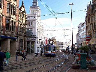
In 1902, a tramway was constructed along the street, which operated until 1930. [4] The street was made a conservation area in 1977. Doncaster Metropolitan Borough Council describes it as one of the town's "most prestigious thoroughfares", with "massive scale, stone construction and blend of civic and corporate character". Most of the buildings are financial or professional services, with some retail. [3]

The road runs south-east, from the junction of Baxter Gate, Frenchgate and St Sepulchre Gate, to a junction with Hall Gate, Silver Street and Cleveland Street. Scot Lane leads off the north-east side, and Priory Place and Priory Walk lead off the south-west side. [3]
Listed buildings on the north-east side of the street include the former Midland Bank, built in 1897; [5] Barclays Bank, completed in 1882; [6] the 17th-century 4, 5 and 6 High Street; [7] NatWest Bank, built in 1925; [8] the Yorkshire Bank, built in 1841; [9] the early-19th century 17 High Street, 18 High Street, and 19 and 20 High Street; [10] [11] [12] 22 High Street, built as public meeting rooms and now a shop; [13] 23 High Street, built around 1800; [14] the late-18th century 24 and 24B High Street; [15] and 25 High Street, also built around 1800. [16]
On the south-west side of the street lie Lloyds Bank, built in 1912; [17] the early-19th century 52 High Street; [18] the mid-18th century 50 and 51 High Street; [19] the former TSB Bank, built about 1920; [20] the Grade I listed Doncaster Mansion House, completed in 1748; [21] the mid-18th century 44 High Street; [22] 43 High Street, originally built as gambling rooms in 1826; [23] the early-19th century 42 High Street; [24] late 18th-century 41 High Street; [25] and the Westminster Building, completed in 1780. [26] Although unlisted, the Danum Hotel, built in 1908, is another prominent building. [3]
Clapham is a district in South West London, England, lying mostly within the London Borough of Lambeth, but with some areas extending into the neighbouring London Borough of Wandsworth.

Doncaster is a city in South Yorkshire, England. Named after the River Don, it is the administrative centre of the larger City of Doncaster. It is the second largest settlement in South Yorkshire after Sheffield. Doncaster is situated in the Don Valley on the western edge of the Humberhead Levels and east of the Pennines. At the 2021 census, the city had a population of 308,100, while its built-up area had a population of 158,141 at the 2011 census.

Warwick is a market town, civil parish and the county town of Warwickshire in the Warwick District in England, adjacent to the River Avon. It is 9 miles (14 km) south of Coventry, and 19 miles (31 km) south-east of Birmingham. It is adjoined with Leamington Spa and Whitnash.

Middlesbrough is a town on the southern bank of the River Tees in North Yorkshire, England. It is near the North York Moors national park and the main town of its local council and borough.

Norton is a village and civil parish in the Metropolitan Borough of Doncaster, on the border with North Yorkshire.

Rossington is a civil parish and former mining village in the Metropolitan Borough of Doncaster in South Yorkshire, England and is surrounded by countryside and the market towns of Bawtry and Tickhill.

Mexborough is a town in the City of Doncaster in South Yorkshire, England. Situated between Manvers and Denaby Main, it lies on the River Don close to where it joins the River Dearne, and the A6023 road runs through the town. It is contiguous with the town of Swinton which is directly to the southwest immediately across the railway and Conisbrough to the east.

Adwick le Street is a village in the City of Doncaster, South Yorkshire, England. The Adwick ward of Doncaster Metropolitan Borough Council had a population of 15,911 at the 2011 Census. It is situated north-west of Doncaster. Under the 2011 census, the settlement had a population of 10,507.

Swinton is a town in the Metropolitan Borough of Rotherham, in South Yorkshire, England on the west bank of the River Don. It has a population of 15,559 (2011). The town is five miles north-northeast of the larger town of Rotherham and directly west-southwest of Mexborough. The original junior and infant school building built 1852 on Church Street formerly Fitzwilliam School still exists being converted into residential apartments called 'Fitzwilliam Lodge'

Ormesby is an area which is split between Borough of Middlesbrough and Borough of Redcar and Cleveland in North Yorkshire, England. It is in the Middlesbrough part of the Teesside built up area.
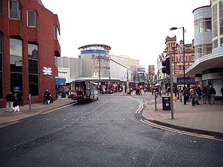
High Street is one of the main thoroughfares and shopping areas in the city centre of Sheffield in South Yorkshire, England, located at the approximate grid reference of SK356874. High Street starts at the Commercial Street, Fitzalan Square and Haymarket junction and runs for approximately 400 metres west to conclude near the Sheffield Cathedral where it forms a Y-junction with Fargate and Church Street. High Street has the traditional wide variety of shops, financial institutions and eating places which are associated with any British town centre.

The Yorkshire Grey was a common name for public houses in England, some still survive but most have now closed or changed their name. They were named for the Yorkshire Grey Horse, a breed commonly used to pull brewery drays.

Oldcotes Dyke is the name of the final section of a river system that drains parts of north Nottinghamshire and the Metropolitan Borough of Rotherham in South Yorkshire, England. Historically, it has supported milling, with seven water mills drawing their power from its water, and ran through the grounds of the Cistercian Roche Abbey. It is a tributary of the River Ryton.

Micklegate is a street in the City of York, England. The name means "Great Street", "gate" coming from the Old Norse gata, or street.
Conisbrough is a ward and Denaby is a civil parish in the metropolitan borough of Doncaster, South Yorkshire, England. The ward and parish contain 18 listed buildings that are recorded in the National Heritage List for England. Of these, two are listed at Grade I, the highest of the three grades, and the others are at Grade II, the lowest grade. The listed buildings are in the town of Conisbrough, and the villages of Denaby Main and Old Denaby. The most important buildings are Conisbrough Castle and St Peter's Church, both listed at Grade I. The other listed buildings include houses, a medieval well cover, a set of stocks, a public house, a railway station and station house, a railway viaduct, two mileposts, another church and a chapel, a drinking fountain, and two war memorials.
St Sepulchre Gate is a pedestrianised street in the city centre of Doncaster, in South Yorkshire, England.

Baxter Gate is a pedestrianised street in the city centre of Doncaster, in South Yorkshire, England.
Town ward is a ward in the metropolitan borough of Doncaster, South Yorkshire, England. The ward contains 105 listed buildings that are recorded in the National Heritage List for England. Of these, two are listed at Grade I, the highest of the three grades, two are at Grade II*, the middle grade, and the others are at Grade II, the lowest grade. The ward contains the central part of the town of Doncaster. Most of the listed buildings in the ward are houses and associated structures, shops, offices, hotels and public houses, commercial buildings, market buildings, and public buildings. The town has an important railway history, and buildings associated with this, including some in Doncaster Works and Doncaster railway station are listed. The other listed buildings include a lock on the River Don Navigation, churches and associated structures, a former theatre, a war memorial, and a former swimming pool and health club.
Hall Gate is a street in the town centre of Doncaster, in South Yorkshire, England.
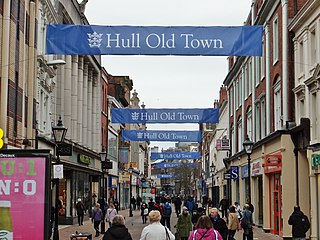
Whitefriargate is a pedestrianised street in the Old Town area of Kingston upon Hull, in the East Riding of Yorkshire, England. During the 20th century, it was one of the main shopping streets in the city centre, but some of the major stores have closed down, which has been attributed to out of town shopping centres. However, the Street still provides a useful link to and from the old town of Hull.