
Consett is a town in the County Durham district, in the ceremonial county of Durham, England, about 14 miles (23 km) south-west of Newcastle upon Tyne. It had a population of 27,394 in 2001 and an estimate of 25,812 in 2019.

Stanley is a town and civil parish in the ceremonial county and district of County Durham, England. Centred on a hilltop between Chester-le-Street and Consett, Stanley lies south-west of Gateshead.

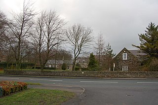
Waskerley is a village in County Durham, England. It is situated six miles to the southwest of Consett and three miles southwest of Castleside and the A68. Stanhope in the Durham Dales is a further six miles to the southwest and the Derwent Reservoir and the village of Edmundbyers is approximately five miles to the north. The village of Muggleswick is three miles to the north.
Burnopfield is a village in County Durham, in England. It is situated north of Stanley and Annfield Plain, close to the River Derwent and is 564 feet above sea level. There are around 4,553 inhabitants in Burnopfield. It is located 7 miles from Newcastle upon Tyne and 15 miles from Durham.
Medomsley is a village in County Durham, England. It is about 2 miles (3 km) northeast of the centre of Consett, 1+1⁄2 miles (2 km) south of Hamsterley and 1 mile (2 km) southeast of Ebchester along the B6309. Leadgate lies a further mile to the south east.

Leadgate is a village in County Durham, in England. It is situated to the north-east of Consett. The Roman road Dere Street runs straight through the middle of Leadgate, today this is known as Durham Road and the B6309.

Low Westwood is a village in County Durham, England. It is situated immediately to the west of Hamsterley. Low Westwood is probably best known for Hamsterley Christ Church and Derwent care home.

Hamsterley is a village in County Durham, England. It is situated to the north of Consett and borders the hamlet of Low Westwood.

Thornley is a village and civil parish in County Durham, England, about 5 miles (9 km) to the east of Durham and 5 miles (7 km) west of Peterlee. The community grew around a coal mine established in 1835, which remained open until 1970.
Rowlands Gill is a village on the north bank of the River Derwent, in the Metropolitan Borough of Gateshead, Tyne and Wear, England. The Gibside Estate is near the town.

Kibblesworth is a village 2 miles (3.2 km) west of Birtley, Tyne and Wear, England. Kibblesworth was a mainly rural community until the development of the pit and brickworks and the resulting increase in population. Following the closure of the pit in 1974, few of the residents now work in the village. Historically in County Durham, it was transferred into the newly created county of Tyne and Wear in 1974.
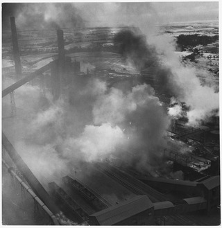
The Consett Iron Company Ltd was an industrial business based in the Consett area of County Durham in the United Kingdom. The company owned coal mines and limestone quarries, and manufactured iron and steel. It was registered on 4 April 1864 as successor to the Derwent & Consett Iron Company Ltd. This in turn was the successor to the Derwent Iron Company, founded in 1840.
The Stanhope and Tyne Railway was an early British mineral railway that ran from Stanhope to South Shields at the mouth of the River Tyne in County Durham, England. It ran through the towns of Birtley, Chester Le Street, West Stanley and Consett. The object was to convey limestone from Stanhope and coal from West Consett and elsewhere to the Tyne, and to local consumers. Passengers were later carried on parts of the line.
The Derwent Valley Railway was a branch railway in County Durham, England. Built by the North Eastern Railway, it ran from Swalwell to Blackhill via five intermediate stations, and onwards to Consett.
Marley Hill is a former colliery village about six miles to the south west of Gateshead, near the border between Tyne and Wear and County Durham. It has been part of the Metropolitan Borough of Gateshead since 1974. Prior to this it was part of Whickham Urban District. It lies within the Whickham South & Sunniside electoral ward of the Blaydon parliamentary constituency.
The Lanchester Valley Railway was an English railway line that was developed by the North Eastern Railway to run between Durham to Consett. Extending 12 miles (19 km) along the valley of the River Browney, it opened on 1 September 1862. Closed under the Beeching Axe, it has been redeveloped by Durham County Council as a foot and cycle path as the Lanchester Valley Railway Path.

Crook railway station served the town of Crook, County Durham, England. It was located on the Bishop Auckland and Weardale Railway line from Bishop Auckland to Blackhill between Wear Valley Junction and Tow Law.
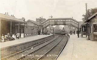
Blackhill railway station served the village of Blackhill, County Durham, England from 1867 to 1955 on the Derwent Valley Line.

