
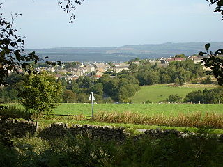
Butterknowle is a village in Teesdale, County Durham, England. Butterknowle is situated between the market towns of Bishop Auckland and Barnard Castle. It has an attractive rural setting within the Gaunless Valley, overlooked by the gorse-covered Cockfield Fell. The fell itself is a scheduled ancient monument, containing evidence of Roman settlements and a medieval coal mine (Vavasours), thought to be the earliest inland colliery recorded.

Allensford is a small country park and hamlet in County Durham, in England. It is on the River Derwent, about 2 miles SW of Consett, and 1 mile north of Castleside.

Dipton is a village located in County Durham, England. It is situated to the north-east of Consett, 3 miles south west of Burnopfield and a short distance to the north-west of Annfield Plain.

Knitsley is a hamlet in and former civil parish, now in the parish of Healeyfield, in the County Durham district, in the ceremonial county of Durham, England. It is situated a short distance to the south of the town of Consett. In 1931 the parish had a population of 2276.
Castleside is a village in County Durham, England. It is situated a short distance to the south-west of Consett. Castleside is covered by the civil parish of Healeyfield.The village centre is located on the main A68 road which runs between Edinburgh and Darlington and the village crossroads allow easy access to Consett, the North Pennines and Stanhope. To the northeast lie other small villages called Moorside and The Grove.

Iveston is a village in County Durham, England. It is situated a short distance to the east of Consett. Housing in the area consists of a mixture of traditional cottages and large, newer residential properties. Historically, farming and mining formed the chief sources of employment in the village. In 1931 the parish had a population of 6395.

High Friarside is a village in County Durham, England classified as a suburban area. It is situated a short distance to the west of Burnopfield.

High Westwood is an English village in County Durham, a few miles to the north of Consett, near Ebchester and Hamsterley. It once had a colliery and coke works.

Edmundbyers is a village in County Durham, in England. It is situated a few miles to the west of Consett, near Derwent Reservoir. In 2001 it had a population of 118. The civil parish of Edmondbyers had a population taken at the 2011 Census of 173.
Medomsley is a village in County Durham, England. It is about 2 miles (3 km) northeast of the centre of Consett, 1+1⁄2 miles (2 km) south of Hamsterley and 1 mile (2 km) southeast of Ebchester along the B6309. Leadgate lies a further mile to the south east.

Mainsforth is a small village and former civil parish, now in the parish of Bishop Middleham, in the County Durham district, in the ceremonial county of Durham, England. It is to the east of Ferryhill. The earliest settlement in Mainsforth may have been on Marble. It has been suggested, without great historical foundation, that this was a Danish settlement. In 1961 the parish had a population of 229. From medieval times through to the early twentieth century the village was in effect a small collection of farms and farm workers' cottages.

Leadgate is a village in County Durham, in England. It is situated to the north-east of Consett. The Roman road Dere Street runs straight through the middle of Leadgate, today this is known as Durham Road and the B6309.

Low Westwood is a village in County Durham, England. It is situated immediately to the west of Hamsterley. Low Westwood is probably best known for Hamsterley Christ Church and Derwent care home.
Crookhall is a village in County Durham, in England. It is situated between Consett and Delves Lane. It is named after, and intimately connected to, Crook Hall which once stood nearby.

Hamsterley is a village in County Durham, England. It is situated a few miles west of Bishop Auckland.

Healeyfield is a village and civil parish in County Durham, England. The population of the civil parish taken from the 2011 census was 1,544. It is situated to the south west of Consett.

Delves Lane is a small village to the south of Consett, County Durham, England. The housing in the area was built as a suburb of Consett, historically providing housing for people working in the former mining and steel industries. The village has one pub: 'The Traveller's Rest'.
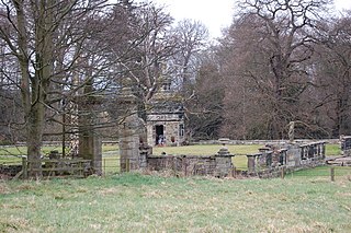
Hamsterley Hall is an 18th-century English country house at Hamsterley, Rowlands Gill, County Durham, England. It is a Grade II* listed building.
