
Cadbury Camp is an Iron Age hill fort in Somerset, England, near the village of Tickenham. It is a scheduled monument. Although primarily known as a fort during the Iron Age it is likely, from artefacts, including a bronze spear or axe head, discovered at the site, that it was first used in the Bronze Age and still occupied through the Roman era into the sub-Roman period when the area became part of a Celtic kingdom. The name may mean "Fort of Cador" - Cado(r) being possibly the regional king or warlord controlling Somerset, Bristol, and South Gloucestershire, in the middle to late 5th century. Cador has been associated with Arthurian England, though the only evidence for this is the reference in the Life of St. Carantoc to Arthur and Cador ruling from Dindraithou and having the power over western Somerset to grant Carantoc's plea to build a church at Carhampton. Geoffrey of Monmouth invented the title 'Duke of Cornwall' for Cador in his misleading History of the Kings of Britain.

Maes Knoll is an Iron Age hill fort in Somerset, England, located at the eastern end of the Dundry Down ridge, south of the city of Bristol and north of the village of Norton Malreward near the eastern side of Dundry Hill. It is a Scheduled Ancient Monument.

Maesbury Castle is an Iron Age hill fort within the parish of Croscombe on the Mendip Hills, just north of Shepton Mallet, Somerset, England. It has been listed as a Scheduled Ancient Monument.
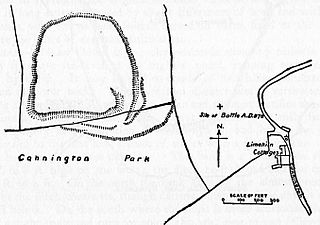
Cannington Camp is a Bronze Age and Iron Age hill fort near Cannington, Somerset, England. It is a Scheduled Ancient Monument.

Cleeve Toot is an Iron Age univallate hillfort above Goblin Combe, Cleeve, Somerset, England. It is a Scheduled Ancient Monument.

Norton Camp is a Bronze Age hill fort at Norton Fitzwarren near Taunton in Somerset, England.

Bats Castle is an Iron Age hill fort at the top of a 213 metres (699 ft) high hill in the parish of Carhampton south south west of Dunster in Somerset, England.

Black Ball Camp is an Iron Age hill fort South West of Dunster, Somerset, England on the northern summit of Gallox Hill. It is a Scheduled Ancient Monument.

Kenwalch's Castle is probably an Iron Age hill fort that may have been converted into a Roman fortress, near Penselwood, Somerset, England, 6.6 kilometres (4 mi) east south east of Bruton at grid reference ST747335. It is a Scheduled Ancient Monument. It is believed to be named after Cenwalh of Wessex.

Kingsdown Camp is an Iron Age hill fort at Buckland Dinham 4.5 kilometres (3 mi) South East of Radstock, Somerset, England. It is a Scheduled Ancient Monument.

Tedbury Camp is a multivallate Iron Age promontory hill fort defended by two parallel banks near Great Elm, Somerset, England.

King's Castle is a Neolithic hillfort 1 kilometre (0.62 mi) east of Wiveliscombe in Somerset, England. It is surrounded by two banks with a ditch between them. The inner wall ranges up to 2.5 metres (8.2 ft) high and the outer wall gets up to 1.5 metres (4.9 ft) high. Arrowheads, scrapers, and borers have been found at the site. A coin hoard of 1139 coins was found in a pot buried 0.30 metres (1 ft) deep.
Curdon Camp is a univallate Iron Age hill fort in the West Somerset district of Somerset, England. It is a Scheduled Ancient Monument.
Westbury Camp is a univallate Iron Age hill fort in the Mendip Hills in Somerset, England. The hill fort is situated in the parish of Rodney Stoke, approximately 1 mile (1.6 km) north-east of the village of Draycott and 1.5 miles (2.4 km) north-west of Westbury-sub-Mendip. The camp is largely situated in a hill slope. The north east defences have largely been destroyed by small quarries over the years. The narrow top of the hill bank suggests that it may have been surmounted by a dry stone wall. Along part of the east side of the camp there are traces of a berm between the bank and the outer ditch and at the western angle shallow quarry pits occur internally and externally set back from the 'rampart'.

Roddenbury Hillfort is a univallate Iron Age hillfort in the parish of Selwood, Somerset, England. It is a Scheduled Ancient Monument and on the Heritage at Risk Register. It is close to the later Hales Castle.
Taps Combe Camp is an Iron Age hill fort in North Somerset, England. The hill fort is situated approximately 1.8 miles (2.9 km) east from the village of Brockley. The hill fort is shaped a lot like a "D", and is approximately 50 metres (160 ft) by 50 metres (160 ft) wide.

Mounsey Castle is an Iron Age irregular triangular earthwork of 1.75 hectares north west of Dulverton, Somerset, England. It has been scheduled as an ancient monument. It has been added to the Heritage at Risk Register.
Conygar Hillfort is a small multivallate Iron Age hill fort in the North Somerset district of Somerset, England. It is a Scheduled Ancient Monument.
Wain's Hill is an univallate Iron Age hill fort situated approximately 1 mile (1.6 km) south-west from the town of Clevedon in the North Somerset district of Somerset, England. The hillfort is defined by a steep, natural slope from the south and north with two ramparts to the east.

Long Wood Enclosure is an enclosure which may have been a univallate Iron Age hill fort, in the West Somerset district of Somerset, England. The hill fort is situated approximately 3.5 kilometres (2.2 mi) southwest of the village of Dunster. It has been scheduled as an ancient monument.

