
Highgate is a suburban area of north west London at the northeastern corner of Hampstead Heath in the London Boroughs of Camden, Islington and Haringey, 4+1⁄2 miles north-northwest of Charing Cross.

Archway is an area of north London, England, in the London Borough of Islington 3.8 miles (6 km) north of Charing Cross. It straddles the A1 and is named after a local landmark, the high, single-arched Highgate Archway Bridge which crossed the road in a cutting to the north. It has a modern commercial hub around Vantage Point and Archway tube station.
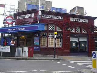
Randolph Avenue is a street in Maida Vale in London. Located in the City of Westminster, it is a long avenue running from north to south. The southern end is located in Little Venice near to the Paddington branch of the Grand Union Canal. The street runs northwards, crossing Clifton Gardens, Sutherland Avenue, Elgin Avenue and Carlton Vale. The road then continues as Randolph Gardens until it meets Kilburn Park Road. The Edgware Road runs directly parallel to Randolph Avenue to the east.

Carlton Vale is a street that runs through Kilburn and Maida Vale in London. Some of its route forms the boundary between the City of Westminster to the south and the London Borough of Brent to the north. To the west the street continues as Kilburn Lane through Queen's Park, while to the east it becomes Carlton Hill running into St. John's Wood. Carlton Vale crosses or meets several roads including Kilburn Park Road, Cambridge Road and Randolph Avenue.

Oakley Square is a crescent-shaped garden square in Somers Town in Central London, close to Mornington Crescent and Camden Town. It is located in the London Borough of Camden and runs roughly northeastwards from Eversholt Street meeting with the southern end of Camden Street on its eastern side.
Well Walk is a street in Hampstead, England in the London Borough of Camden. It runs southwestwards from Hampstead Heath to Flask Walk which then continues on towards the centre of Hampstead Village around the Hampstead tube station. It takes its name from the historic Hampstead Wells.

New End Square is a square in Hampstead, in the London Borough of Camden. It dates back to the early eighteenth century when it was located close to the Hampstead Wells spa on the adjacent Well Walk. Despite its name it is not rectangular. At its northern end is the Old White Bear pub dating back to 1704, on the corner with Well Road. Its southern end is at the junction between Flask Walk and Well Walk. New End street curls off from one corner of the square, eventually heading west to Heath Street.

Flask Walk is a street in Hampstead in the London Borough of Camden. It runs eastwards from Hampstead High Street to a junction with Well Walk and New End Square. It is primarily residential but the western end of the street is a pedestrianised alley featuring commercial properties. Hampstead tube station is located close to the junction with the High Street.

Hampstead Grove is a street in Hampstead in the London Borough of Camden. It heads northwards from Holly Hill running towards Hampstead Heath, but curving back towards Lower Terrace which connects it to the Heath. It runs roughly parallel to Heath Street to its east. It takes its name from the groves of trees that marked the landscape.

Maresfield Gardens is a street in Hampstead. Located in the London Borough of Camden, it runs parallel to the west of Fitzjohns Avenue for much of its route before curving to join it at is southern end. It crosses Nutley Terrace and Netherhall Gardens. The Belsize Tunnel passes underneath the street. It primarily feature red brick buildings.

Hampstead Hill Gardens is a street in Hampstead in the London Borough of Camden. It runs eastwards off the Rosslyn Hill stretch of the A502 road before looping round to join Pond Street to the south. The land was considered as a potential location for Hampstead Town Hall before a nearby site on Haverstock Hill was selected. The Hampstead Heath Tunnel of the North London Line passes under the street.

Branch Hill is a street in Hampstead. Located in the London Borough of Camden it is named after a hill on Hampstead Heath and runs adjacent to the heath between Frognal Rise and West Heath Road. Branch Hill, then largely open countryside, was a favourite landscape of the artist John Constable and he painted it on a number of occasions. Branch Hill Pond is located close to the junction with West Heath Road, while it dried up in the early twentieth century recent efforts have been made to restore it.

Delancey Street is a mainly residential street in Camden Town, London, England. Located in the London Borough of Camden, it runs roughly west to east in a curve from Camden High Street to Parkway. It is met or crossed by Arlington Road, Albert Street, Gloucester Avenue, and Mornington Terrace. Eastwards of Camden High Street the route continues as Pratt Street as far as the Regent's Canal.

Mornington Terrace is a street in Camden Town. Located in the London Borough of Camden, it runs southeastwards from Delancey Street following the route of the main line into Euston that runs immediately to its west. At its southern end it becomes Clarkson Row while Mornington Place connects it to Mornington Crescent. Both Mornington Terrace and Place are notable for their surviving Victorian houses.

The Gatehouse is a public house in Highgate, London, located at a road junction where Highgate High Street, West Hill, North Hill and Hampstead Lane converge close to Pond Square. It stands on the site of the oldest recorded structure in Highgate Village. A toll road was constructed in the early fourteenth century and an arched gateway was constructed under which all passing had to pay. This gave its name to the area.
Pond Square is a garden square and village green in Highgate, London. Located close to Highgate High Street and The Gatehouse it is today in the London Borough of Camden. Swain's Lane runs off the square heading downhill past Highgate Cemetery.

Prince of Wales is a Grade II listed public house in Highgate, London. Located on Highgate High Street, the building dates back to the eighteenth century. It became a pub in 1864 when the future Edward VII held the title of Prince of Wales. Amongst former landlords was the retired sportsman Leslie Compton who played cricket for Middlesex and football for Arsenal. The rear of the pub faces on to Pond Square. The pub and neighbouring buildings have been listed since 1974.

Highgate West Hill is a street in Highgate, London. Located in the London Borough of Camden it runs north to south with Hampstead Heath off to its west and Highgate Cemetery away to the east. A number of streets run off the road including The Grove, Millfield Lane and Hillway. The route dates back to the medieval era.

Mansfield Road is a street in the Gospel Oak area of Hampstead. It runs east to west from a junction with Fleet Road and Southampton Road to Gospel Oak Station where it becomes Gordon House Road which runs on as far as the Highgate Road. Today it forms part of the B518 route.

Swain's Lane is a street in Highgate in the London Borough of Camden. It runs up Highgate Hill, for much of its route alongside Highgate Cemetery and Waterlow Park. It is noted for its steepness. It runs uphill from a junction with Highgate Road and Highgate West Hill close to Hampstead Heath. Its northern end terminates on South Grove close to Pond Square in the heart of old Highgate village.

