Highway 401 (Thailand)

Last updated
Thai Highway-401.svg
National Highway 401
ทางหลวงแผ่นดินหมายเลข 401
Route information
Length287.682 km [1]  (178.757 mi)
Major junctions
West end Amphoe Takua Pa
  Nakhon Si Thammarat
Southeast end Ban Tha Pae
Highway system
Highways in Thailand
Route 401 near Khlong Phanom National Park, Surat Thani Khlong Phanom, Highway 401, Surat Thani, Thailand.jpg
Route 401 near Khlong Phanom National Park, Surat Thani
Route 401 at Khao Sok National Park, Phanom district, Surat Thani province Khao Sok (Kkhao Sok mart 2013) - panoramio (1).jpg
Route 401 at Khao Sok National Park, Phanom district, Surat Thani province
Route 401 near Ban Ta Khun, Surat Thani Khlong Phanom, Highway 401, Trees, Surat Thani, Thailand.jpg
Route 401 near Ban Ta Khun, Surat Thani

Highway 401 is a national highway in Southern Thailand. It starts from the west coast of the Thai-Malay Peninsula at an intersection with Phetkasem Road (Highway 4) near Amphoe Takua Pa, Phang Nga Province.

Contents

The route runs eastward through Surat Thani Province to the east coast, then southward to Nakhon Si Thammarat Province. It ends at Ban Tha Pae, about 10 km north of Nakhon Si Thammarat town. Highway 4012 then connects Ban Tha Pae to Nakhon Si Thammarat town.

Route Details

Route 401 is the main road that connects Surat Thani and Nakhon Si Thammarat. It starts near Amphoe Takua Pa as a two-lane single carriageway. Running eastward, it passes through Phanom, Ban Ta Khun districts to Phunphin district. Then it widens to a four-lane dual carriageway and continues to Surat Thani, Amphoe Kanchanadit. It enters Nakhon Si Thammarat province at Amphoe Khanom, but does not pass the town of Khanom. It, then, goes southward pass Amphoe Sichon, Amphoe Tha Sala and ends at Ban Tha Pae, about 10 km north of Nakhon Si Thammarat. Total length is 287.682 km. Of this, 23.628 km is in Phang Nga Province, 186.458 km in Surat Thani Province and 77.596 km in Nakhon Si Thammarat Province. [1]

Most of the route is asphalt. However, a short section from Phun Phin till the start of the Surat Thani bypass is concrete. Almost all of the four-lane section is divided highway, with the exception of short sections at Ban Ton Reang and Ban Tha Pae.

From Amphoe Phunphin to Amphoe Khanom, the route crosses many hills. The highest is Khao Hua Chang, a few kilometers before the intersection with Route 4014. About 1 km east of Khao Hua Chang, the route expand to six lanes, with the outermost lane for slow vehicles such as trucks. Between Amphoe Sichon and Ban Tha Pae, it's mostly level. At Amphoe Tha Sala, the route runs very near the coast (10–50 m) for about 2 km. This is the only section of Route 401 that runs adjacent to the sea.

The section of Route 401 between the intersection with Route 4008 near Amphoe Phun Phin and the intersection with Route 4103 near Ban Tha Pae was once heavily used as a main access route to Bangkok for the lower southern provinces. However, when a new section of Route 41 between Phunphin and Thungsong was finished, the majority of traffic has moved to the new route.

There are two bypasses on Route 401, around Surat Thani (10.282 km) and Tha Sala (4.27 km). [1]

Most of the road from Phunphin to Takua Pa is now viewable on Google Street View, the first long-distance countryside road in southern Thailand to be recorded.

List of intersections

Phang Nga Province

Surat Thani Province

Nakhon Si Thammarat Province

Route 4012

Thai Highway-4012.svg

Highway 4012

Location Ban Tha PaeNakhon Si Thammarat
Length8 km (5.0 mi)

Route 4012 starts at Ban Tha Pae, at exactly the point where Route 401, and runs south to Nakhon Si Thammarat town. [2] In the 2016 highway realignment included 4012 as part of Route 401.[ citation needed ] It is four-lane asphalt, two in each direction separated by a median.

Originally, the route passed through Fort Vachirawut. This was inconvenient because at night only vehicles with permission cards could use the route. Vehicles without permission used routes 4016 and 4013 to avoid Fort Vachirawut.

A new 4012 roadway was constructed about 1 km east of Fort Vachirawut. The newer route allows 24-hour access by all vehicles. The new route is usually known to locals as Thanon Om Kai (Fort-devious Road).

List of intersections

Related Research Articles

Surat Thani Province Largest province of Thailand

Surat Thani, often shortened to Surat, is the largest of the southern provinces (changwat) of Thailand. It lies on the western shore of the Gulf of Thailand. Surat Thani means 'city of good people', a title given to the city by King Vajiravudh ; Surat Thani is therefore the sole province in Southern Thailand for which the native name is in the Central Thai language.

Phang Nga Province Province of Thailand

Phang Nga is one of the southern provinces (changwat) of Thailand, on the shore of the Andaman Sea to the west and Phang Nga Bay to the south. Neighboring provinces are Ranong, Surat Thani, and Krabi. To the south is the Phuket Province, connected by the Sarasin Bridge.

Surat Thani City in Surat Thani Province in southern Thailand

Surat Thani is a city in Amphoe Mueang Surat Thani, Surat Thani Province, southern Thailand. It lies 651 km (405 mi) south of Bangkok. It is the capital of Surat Thani Province. The city has a population of 132,040 (2019), and an area of 68.97 km2 (26.63 sq mi). The city's population density is 1,914 inhabitants per km2.

Phunphin District District in Surat Thani, Thailand

Phunphin is a district (amphoe) in Surat Thani Province in the south of Thailand. Tha Kham is the principal town of the district. In 2014, the population was 73,067.

Kanchanadit District District in Surat Thani, Thailand

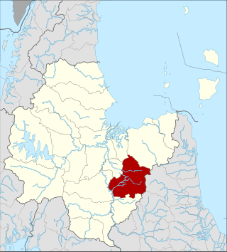
Kanchanadit is a district (amphoe) in Surat Thani Province, south Thailand.

Takua Pa District District in Phang Nga, Thailand

Takua Pa is a district (amphoe) in Phang Nga Province in south Thailand.

Southern Thailand Region in Thailand

Southern Thailand, Southern Siam or Tambralinga is a southernmost cultural region of Thailand, separated from Central Thailand region by the Kra Isthmus.

Phanom District District in Surat Thani, Thailand

Phanom is a district (amphoe) in the southwest of Surat Thani Province of southern Thailand.

Khiri Rat Nikhom District District in Surat Thani, Thailand

Khiri Rat Nikhom is a district (amphoe) in western Surat Thani Province, southern Thailand.

Khanom District District in Nakhon Si Thammarat, Thailand

Khanom is the northernmost district (amphoe) of Nakhon Si Thammarat Province, southern Thailand.

Ban Na San District District in Surat Thani, Thailand

Ban Na San is a district (amphoe) of Surat Thani Province, Thailand.

Khura Buri District District in Phang Nga, Thailand

Khura Buri is a district (amphoe) in Phang Nga Province in the south of Thailand.

Kapong District District of Thailand

Kapong is a district (amphoe) in Phang Nga Province in south Thailand.

Highway 41 starts at intersection with Route 4 in Chumphon Province. It goes southward passing through Surat Thani Province and Nakhon Si Thammarat Province. It ends at Phatthalung Province joining Route 4 again.

Sichon District District in Nakhon Si Thammarat, Thailand

Sichon is a district (amphoe) of Nakhon Si Thammarat Province, southern Thailand.

Nopphitam District District in Nakhon Si Thammarat, Thailand

Nopphitam is a district (amphoe) of Nakhon Si Thammarat Province, southern Thailand.

Tha Sala District District of Thailand

Tha Sala is a district (amphoe) of Nakhon Si Thammarat Province, southern Thailand.

Highway 44 is part of land bridge project running across the Kra Isthmus. It starts at intersection with Phetkasem highway in Krabi Province, running northeast, and ends at intersection with Highway 401 in Surat Thani Province. It roughly follows the route that a centuries-discussed Thai Canal might follow, if ever built.

Highway 403 is a road in Thailand that is divided into 3 sections. The first section starts at Amphoe Mueang Nakhon Si Thammarat. It goes south-westward and join Route 41 at Suan Pak junction. The 2nd section starts at Chong Khao junction. It goes westward to Amphoe Thung Song, then goes southward and join with Route 4 near Amphoe Huai Yot. The 3rd sections starts at Amphoe Mueang Trang. It goes south-westward and ends at Amphoe Kantang

Thai highway network

The Thai highway network follows the left-hand traffic rule of the road. The network is the twin responsibility of the Department of Highways, and the Department of Rural Roads, under the oversight of the Transportation ministry of Thailand. Public highways are also called public roads, especially when part of urban streets. The network spans over 70,000 kilometers across all regions of Thailand. Most are single carriageways. Dual carriageways have frequent u-turn lanes and intersections slowing down traffic. Coupled with the increase in the number of vehicles and the demand for a limited-access motorway, the Thai Government issued a Cabinet resolution in 1997 detailing the motorway construction master plan. Some upgraded sections of highway are being turned into a "motorway", while other motorways are not being built from highway sections.

References

  1. 1 2 3 Highway information database Archived 2009-04-26 at the Wayback Machine , Department of Highways (in Thai). Retrieved on November 11, 2008.
  2. Roads in Thailand: Thai Highway Network, Ah3, Thai Motorway Network, Ah1, Sukhumvit Road, Thailand Route 401, Bang Na Expressway. General Books LLC. 2010. p. 162.