Highway 44 (Thailand)

Last updated
Thai Highway-44.svg
National Highway 44
ทางหลวงแผ่นดินหมายเลข 44
Major junctions
Southwest end Surat Thani
8°18.11′N98°47.03′E / 8.30183°N 98.78383°E / 8.30183; 98.78383 Coordinates: 8°18.11′N98°47.03′E / 8.30183°N 98.78383°E / 8.30183; 98.78383
Major intersections Nakhon Si Thammarat
Northeast end Trang
9°9.47′N99°31.02′E / 9.15783°N 99.51700°E / 9.15783; 99.51700
Location
Country Thailand
Highway system

Highway 44 is part of land bridge project running across the Kra Isthmus. It starts at intersection with Phetkasem highway (Highway 4) in Krabi Province, running northeast, and ends at intersection with Highway 401 in Surat Thani Province. It roughly follows the route that a centuries-discussed Thai Canal might follow, if ever built.

Contents

Construction of Highway 44 began in the 1990s and was completed in 2003 at a cost of US$109.7 million. [1] [2]

Route details

Route 44 is part of land bridge project of Thailand's southern seaboard. However, the other parts of project have not yet built. Route 44 was slated to connect seaports on both the western and eastern coasts of Thailand. However, as the locations of seaports have not yet been finalized, only the central portion of Route 44 has been constructed. The roughly 50 km missing portions will be built when the location of the seaports has been finalized.

Wide ditch between directions Th route44 median.jpg
Wide ditch between directions

Route 44 is unique in that it was designed to accompany other forms of transportation. Both directions of the road were built 150 metres apart. The large centre median will be used for railroad tracks and a pipeline. However, the project is currently stalled and nothing has been built but the roadways, leaving the centre of the highway empty. There are also no crossing intersections, the only way to cross the highway is to use the U-turns or one of the few bridges.

U-turn Th route44 uturn.jpg
U-turn

In Krabi Province, it starts at Amphoe Ao Luek and passes through Plai Phraya. It enters Surat Thani Province at Amphoe Phrasaeng and passes through Amphoe Khian Sa, Amphoe Ban Na Doem, Amphoe Mueang Surat Thani and ends at Amphoe Kanchanadit.

Total length is about 190 km. About 40 km is in Krabi Province and 150 km in Surat Thani Province. Route 44 is asphalt for entire length and has four lanes total, two lanes in each direction with a 150-metre-wide ditch to separate the roadways.

List of intersections

Related Research Articles

<span class="mw-page-title-main">Surat Thani province</span> Largest province of Thailand

Surat Thani, often shortened to Surat, is the largest of the southern provinces (changwat) of Thailand. It lies on the western shore of the Gulf of Thailand. Surat Thani means 'city of good people', a title given to the city by King Vajiravudh ; Surat Thani is therefore the sole province in Southern Thailand for which the native name is in the Central Thai language.

<span class="mw-page-title-main">Surat Thani</span> City in Surat Thani Province in southern Thailand

Surat Thani is a city in Amphoe Mueang Surat Thani, Surat Thani Province, southern Thailand. It lies 651 km (405 mi) south of Bangkok. It is the capital of Surat Thani Province. The city has a population of 132,040 (2019), and an area of 68.97 km2 (26.63 sq mi). The city's population density is 1,914 inhabitants per km2.

<span class="mw-page-title-main">Phunphin district</span> District in Surat Thani, Thailand

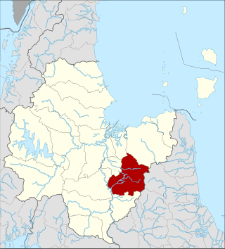
Phunphin is a district (amphoe) in Surat Thani province in the south of Thailand. Tha Kham is the principal town of the district. In 2014, the population was 73,067.

<span class="mw-page-title-main">Kanchanadit district</span> District in Surat Thani, Thailand

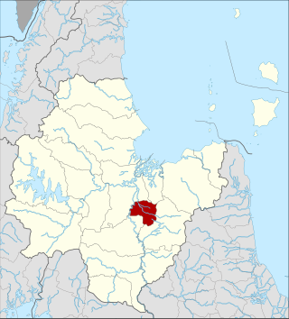
Kanchanadit is a district (amphoe) in Surat Thani province, south Thailand.

<span class="mw-page-title-main">Mueang Surat Thani district</span> Place in Surat Thani, Thailand

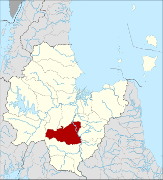
Mueang Surat Thani, or colloquially Ban Don District, is the capital district of Surat Thani province in southern Thailand.

<span class="mw-page-title-main">Khian Sa district</span> District in Surat Thani, Thailand

Khian Sa is a district (amphoe) in Surat Thani province, Thailand.

<span class="mw-page-title-main">Phrasaeng district</span> District in Surat Thani, Thailand

Phraseang is a district (amphoe) of Surat Thani province, Thailand.

<span class="mw-page-title-main">Phanom district</span> District in Surat Thani, Thailand

Phanom is a district (amphoe) in the southwest of Surat Thani province of southern Thailand.

<span class="mw-page-title-main">Ao Luek district</span> District in Krabi, Thailand

Ao Luek is a district (amphoe) in Krabi province, Thailand.

<span class="mw-page-title-main">Plai Phraya district</span> District in Krabi, Thailand

Plai Phraya is a district (amphoe) in Krabi province, Thailand.

Khlong Phraya is a wildlife sanctuary in southern Thailand, at the boundary of Surat Thani and Krabi Provinces.

<span class="mw-page-title-main">Ban Na Doem district</span> District in Surat Thani, Thailand

Ban Na Doem is a district (amphoe) of Surat Thani province, Thailand.

<span class="mw-page-title-main">Ban Na San district</span> District in Surat Thani, Thailand

Ban Na San is a district (amphoe) of Surat Thani province, Thailand.

<span class="mw-page-title-main">Highway 401 (Thailand)</span>

Highway 401 is a national highway in Southern Thailand. It starts from the west coast of the Thai-Malay Peninsula at an intersection with Phetkasem Road near Amphoe Takua Pa, Phang Nga Province.

<span class="mw-page-title-main">Thap Put district</span> District in Phang Nga, Thailand

Thap Phut is a district (amphoe) in Phang Nga province in the south of Thailand.

Highway 41 starts at intersection with Route 4 in Chumphon Province. It goes southward passing through Surat Thani Province and Nakhon Si Thammarat Province. It ends at Phatthalung Province joining Route 4 again.

<span class="mw-page-title-main">Khao Phanom district</span> District in Krabi, Thailand

Khao Phanom is a district (amphoe) in Krabi province, Thailand.

Highway 403 is a road in Thailand that is divided into 3 sections. The first section starts at Amphoe Mueang Nakhon Si Thammarat. It goes south-westward and join Route 41 at Suan Pak junction. The 2nd section starts at Chong Khao junction. It goes westward to Amphoe Thung Song, then goes southward and join with Route 4 near Amphoe Huai Yot. The 3rd sections starts at Amphoe Mueang Trang. It goes south-westward and ends at Amphoe Kantang

<span class="mw-page-title-main">Thai highway network</span>

The Thai highway network follows the left-hand traffic rule of the road. The network is the twin responsibility of the Department of Highways, and the Department of Rural Roads, under the oversight of the Transportation ministry of Thailand. Public highways are also called public roads, especially when part of urban streets. The network spans over 70,000 kilometers across all regions of Thailand. Most are single carriageways. Dual carriageways have frequent u-turn lanes and intersections slowing down traffic. Coupled with the increase in the number of vehicles and the demand for a limited-access motorway, the Thai Government issued a Cabinet resolution in 1997 detailing the motorway construction master plan. Some upgraded sections of highway are being turned into a "motorway", while other motorways are not being built from highway sections.

<span class="mw-page-title-main">Tha Sathon</span>

Tha Sathon is a tambon (sub-district) of Phunphin District, Surat Thani province, southern Thailand.

References

  1. "Thailand's Most Thrilling Motorcycle Adventure". 2020-06-06. Retrieved 2022-05-02.
  2. "Thailand considers railroad to replace the 28 billion dollar Kra Canal concept--Seetao". www.seetao.com. Retrieved 2022-05-02.