
Helsinki is the capital and most populous city in Finland. It is on the shore of the Gulf of Finland and is the seat of southern Finland's Uusimaa region. About 675,000 people live in the municipality, with 1.25 million in the capital region and 1.58 million in the metropolitan area. As the most populous urban area in Finland, it is the country's most significant centre for politics, education, finance, culture, and research. Helsinki is 80 kilometres (50 mi) north of Tallinn, Estonia, 360 kilometres (220 mi) north of Riga, Latvia, 400 kilometres (250 mi) east of Stockholm, Sweden, and 300 kilometres (190 mi) west of Saint Petersburg, Russia. Helsinki has significant historical connections with these four cities.
Kangasala is a town in Finland, located in the Pirkanmaa region. It lies to the east of the regional capital, Tampere. The population of Kangasala is approximately 33,000, while the metropolitan area has a population of approximately 417,000. It is the 35th most populous municipality in Finland.

Rauma is a town in Finland, located on the western coast of the country. Rauma is situated in the Satakunta region, along the Gulf of Bothnia. The population of Rauma is approximately 39,000, while the sub-region has a population of approximately 66,000. It is the 29th most populous municipality in Finland.

Hanko is a town in Finland, located in the southern coast of the country. Hanko is situated in the western part of the Uusimaa region. The population of Hanko is approximately 8,000, while the sub-region has a population of approximately 40,000. It is the 121st most populous municipality in Finland.
A tower is a tall structure, taller than it is wide, often by a significant factor. Towers are distinguished from masts by their lack of guy-wires and are therefore, along with tall buildings, self-supporting structures.

Kotka is a town in Finland, located on the southeastern coast of the country at the mouth of the Kymi River. The population of Kotka is approximately 51,000, while the sub-region has a population of approximately 80,000. It is the 21st most populous municipality in Finland, and the 16th most populous urban area in the country.

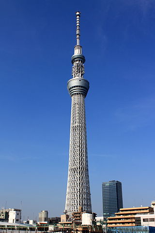
Näsinneula is an observation tower in Tampere, Finland, overseeing Lake Näsijärvi. It was built in 1970–1971 and was designed by Pekka Ilveskoski. It is the tallest free-standing structure in Finland and at present the tallest observation tower in the Nordic countries at a height of 168 metres (551 ft). The tower opened in 1971 and is located in the Särkänniemi amusement park. There is a revolving restaurant in the tower 124 metres (407 ft) above the ground; one revolution takes 45 minutes. The design of Näsinneula was inspired by the Space Needle in Seattle. The idea of a revolving restaurant was taken from the Puijo Tower, which is located in Kuopio, the city of North Savonia.

Hailuoto is a Finnish island in the northern Baltic Sea and a municipality in Northern Ostrobothnia region. The population of Hailuoto is 948, making it the smallest municipality in Northern Ostrobothnia and the former Oulu Province in terms of population. The municipality covers an area of 205.65 km2 (79.40 sq mi) of which 1.70 km2 (0.66 sq mi) is inland water. The population density is 4.61/km2 (11.9/sq mi). Of all the Finnish sea islands, Hailuoto is the third largest after Fasta Åland and Kimitoön.

Sottunga is an island municipality of Åland, an autonomous territory of Finland. The municipality is the smallest when it comes to population in Åland and in Finland, with a population of only 115 (31 December 2023) and covers an area of 342.44 square kilometres (132.22 sq mi) of which 314.41 km2 (121.39 sq mi) is water. The population density is 4.1 inhabitants per square kilometre (11/sq mi). The municipality is unilingually Swedish, with 93% of the inhabitants speaking Swedish as their native language. Sottunga comprises many islands, of which only three, Husö, Finnö and Storsottunga, are inhabited. Storsottunga is usually called Sottunga. There are five villages in the municipality: Finnö, Husö, Hästö, Mosshaga and Sottunga. The highest point of Sottunga is Kasberget.

Turku Castle is a medieval structure in the city of Turku, Finland. Together with Turku Cathedral, the castle is one of the oldest buildings still in use in Finland. It is also the largest surviving medieval building in Finland. It was founded in the late 13th century and stands on the banks of the Aura River. The castle served as a bastion and administrative center in the region of Finland until the early 19th century. It played a role in power struggles within Sweden and the Kalmar Union and stood sieges, with additional battles fought outside its walls. The castle was at its peak in the mid-16th century during the reign of Duke John of Finland and Catherine Jagellon. It lost its status as an administrative center in the 17th century, after Per Brahe's period as governor-general of Finland came to an end. Turku Castle is Finland's most visited museum. Visitations reach well over 100,000 people annually. Some of the rooms in the castle are used for municipal functions.

Kajaani Castle was built on the Ämmäkoski island of the Kajaani River in the centre of Kajaani, Finland, in the 17th century. Today, only roofless ruins remain of the castle. It is the last castle of the Middle Ages that was constructed in Sweden. The flourishing period was during Per Brahe the Younger reign in 1670´s when it was decided the change for the castle for the nobles but 15 years later those fiefs dismissed and the castle became an ordinary centrum of the government for the Swedish Nordic reach.

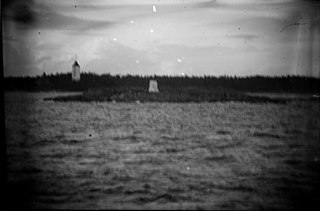
The Keskiniemi beacon tower, often referred to as the Karvo beacon tower, is a historic daymark located on a promontory of Keskiniemi in the northwestern part of Hailuoto island in the Gulf of Bothnia in Finland. The tower was built in 1858 to alert the vessels about sandbars reaching northwest from the site. It is the oldest surviving navigational aid on Hailuoto island. The tower has structural similarities with the Härkmeri beacon tower built in 1857.

Laitakari beacon tower is a daymark located on the island of Laitakari in the Gulf of Bothnia in Finland. The island is located east-northeast of Hailuoto and is within the municipal boundaries of the City of Oulu. There has been a navigational aid on the island since the 1750s, and a beacon tower has been marked on a chart dated in 1785.
Tasku beacon tower is a daymark tower located on the island of Tasku in the Raahe archipelago in the Gulf of Bothnia in Finland. The structure was built in 1853 from the plans drawn by Albin Stjerncreutz. In 1983 the Finnish Maritime Administration handed it over to the City of Raahe. Currently the city is responsible of the upkeep of this historical aid to navigation. The Tasku beacon tower is one of three historical beacon towers in Raahe archipelago, however only two beacon towers remain: the second one is the Iso-Kraaseli beacon tower.

Lågskär Lighthouse is an automated lighthouse located on the north side of Lågskär, one of Finland's Åland in the Sea of Åland of the Baltic. It is the only striking feature on Lågskär on the generally uninhabited island.

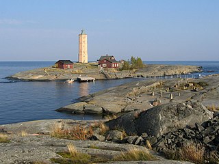
The Utö Lighthouse is located on the island of Utö, in Pargas municipality, Finland. The 24-metre-high (79 ft) tower is situated on the island's summit. After the original round lighthouse was destroyed during the Russo-Swedish Wars of 1808-09, the present structure was constructed in 1814, with the present lens installed in 1906.
The Glosholm Lighthouse was a lighthouse on a southern tip of the Glosholm Island in the Pellinge archipelago in the Gulf of Finland, outside of Porvoo. With increasing sea traffic in the area, the lighthouse was constructed during the years 1832–1835. It served from 1835 to 1863, when it was replaced by the Söderskär Lighthouse. The structure served as a daymark until 1940, when it was blown up.
The Söderskär lighthouse is a decommissioned 19th-century lighthouse in the outer Porvoo archipelago of the Gulf of Finland. It was built in 1862, replacing an earlier unilluminated daymark, automated in 1957, and decommissioned in 1989.