Hilario Ascasubi, Buenos Aires

Last updated
Hilario Ascasubi
Argentina location map.svg
Red pog.svg
Hilario Ascasubi
Location in Argentina
Coordinates: 39°22′S62°38′W / 39.367°S 62.633°W / -39.367; -62.633
CountryFlag of Argentina.svg  Argentina
Province Bandera Buenos Aires.svg Buenos Aires
Partido Villarino
Population
 (2005)
  Total4,689

Hilario Ascasubi is a town in the southwest corner Buenos Aires Province, Argentina, in the partido of Villarino Partido. It is located on National Route 3 (Argentina). The town is named after Argentine poet Hilario Ascasubi, and railroad service opened in the town in 1913.

Contents

The town is located approximately 70 km south of Médanos (the capital of Villarino Partido), and 106 km south of Bahía Blanca, the nearest major city.

Climate

Hilario Ascasubi has borderline humid subtropical climate/semi-arid climate (Köppen climate classification Cfa/BSk). [1] with hot, summers and cooler, drier winters.

Climate data for Hilario Ascasubi (1966–2013)
MonthJanFebMarAprMayJunJulAugSepOctNovDecYear
Record high °C (°F)42.9
(109.2)
39.6
(103.3)
39.1
(102.4)
32.6
(90.7)
29.1
(84.4)
26.9
(80.4)
26.1
(79.0)
28.5
(83.3)
30.8
(87.4)
33.8
(92.8)
37.5
(99.5)
39.7
(103.5)
42.9
(109.2)
Mean daily maximum °C (°F)29.7
(85.5)
29.0
(84.2)
25.5
(77.9)
21.2
(70.2)
17.3
(63.1)
13.6
(56.5)
13.6
(56.5)
16.0
(60.8)
18.7
(65.7)
21.9
(71.4)
25.3
(77.5)
28.3
(82.9)
21.7
(71.1)
Daily mean °C (°F)22.3
(72.1)
21.2
(70.2)
18.6
(65.5)
14.8
(58.6)
11.1
(52.0)
8.0
(46.4)
7.6
(45.7)
9.3
(48.7)
11.7
(53.1)
14.6
(58.3)
18.0
(64.4)
20.8
(69.4)
14.8
(58.6)
Mean daily minimum °C (°F)14.0
(57.2)
13.4
(56.1)
11.5
(52.7)
8.1
(46.6)
4.8
(40.6)
2.5
(36.5)
1.7
(35.1)
2.6
(36.7)
4.6
(40.3)
7.4
(45.3)
10.4
(50.7)
12.8
(55.0)
7.8
(46.0)
Record low °C (°F)1.5
(34.7)
1.4
(34.5)
0.2
(32.4)
−2.6
(27.3)
−6.0
(21.2)
−9.5
(14.9)
−10.8
(12.6)
−8.2
(17.2)
−7.5
(18.5)
−4.2
(24.4)
−1.1
(30.0)
1.7
(35.1)
−10.8
(12.6)
Average precipitation mm (inches)49.4
(1.94)
55.9
(2.20)
62.4
(2.46)
44.6
(1.76)
28.1
(1.11)
22.8
(0.90)
22.0
(0.87)
26.1
(1.03)
37.2
(1.46)
44.7
(1.76)
44.0
(1.73)
52.0
(2.05)
492.0
(19.37)
Average relative humidity (%)57606768737572676463585765
Mean monthly sunshine hours 310.0268.4244.9198.0164.3132.0139.5179.8195.0238.7270.0291.42,632
Source: Instituto Nacional de Tecnología Agropecuaria [2]

See also

Related Research Articles

<span class="mw-page-title-main">Desert climate</span> Arid climate subtype in the Köppen climate classification system with very little precipitation

The desert climate or arid climate is a dry climate sub-type in which there is a severe excess of evaporation over precipitation. The typically bald, rocky, or sandy surfaces in desert climates are dry and hold little moisture, quickly evaporating the already little rainfall they receive. Covering 14.2% of Earth's land area, hot deserts are the second most common type of climate on Earth after the polar climate.

<span class="mw-page-title-main">Progreso, Yucatán</span> City in the Mexican state of Yucatán

Progreso is a port city in the Mexican state of Yucatán, located on the Gulf of Mexico in the north-west of the state some 30 minutes north of state capital Mérida by highway. As of the Mexican census of 2010, Progreso had an official population of 37,369 inhabitants, the sixth largest community in the state in population. The city is also the municipal seat of the surrounding municipality of the same name. The municipality's area is 270.10 km2 (104.29 sq mi) and its population at the census was 49,454 inhabitants. It includes Scorpion Reef with its five islets 130 km offshore (north) on the outer edge of Campeche Bank. Its largest other towns are Chicxulub Puerto, Campestre Flamboyanes, and Chelem.

<span class="mw-page-title-main">Tandil</span> City in Buenos Aires, Argentina

Tandil is the main city of the homonymous partido (department), located in Argentina, in the southeast of Buenos Aires Province, just north-northwest of Tandilia hills. The city was founded in 1823 and its name originates from the Piedra Movediza which fell in 1912. The city is the birthplace of many notable sports personalities, as well as former president of Argentina Mauricio Macri.

<span class="mw-page-title-main">Pyramid Mountain (Alberta)</span> Mountain in Alberta, Canada

Pyramid Mountain is a mountain in Jasper National Park, Alberta, Canada, named for its pyramid-like shape. James Hector named the mountain in 1859 due to its appearance from the Athabasca River valley on the eastern side of the peak.

<span class="mw-page-title-main">Trenque Lauquen</span> City in Buenos Aires Province, Argentina

Trenque Lauquen is a city in the west of the province of Buenos Aires, Argentina, 444 km (276 mi) from Buenos Aires City and 80 km (50 mi) from the border with the province of La Pampa, on the intersection of National Routes 5 and 33. Trenque Lauquen is the largest city of the district (partido) of the same name, and has a population of about 40,000 inhabitants as per the 2001 census [INDEC].

<span class="mw-page-title-main">Bandundu (city)</span> Provincial capital and city in Kwilu, DR Congo

Bandundu, formerly known as Banningville or Banningstad, is the capital city of Kwilu Province of the Democratic Republic of the Congo.

<span class="mw-page-title-main">Pehuajó</span> City in Buenos Aires Province, Argentina

Pehuajó is a city in the Pehuajó Partido in the province of Buenos Aires, Argentina. The partido has about 38,400 inhabitants as per the 2001 census [INDEC]. The name of this relatively small city is well known in Argentina because of María Elena Walsh's song Manuelita, about an adventurous turtle (tortoise); a dilapidated concrete statue of María Elena Walsh's Manuelita lies just outside the city, beside Ruta Nacional 5.

<span class="mw-page-title-main">Cipolletti</span> City in Río Negro Province, Argentina

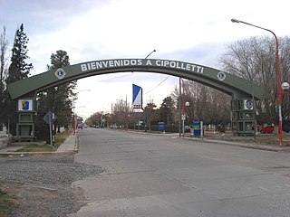
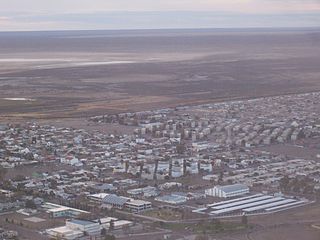
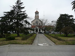
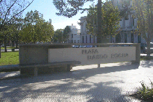
Cipolletti is a city in north of the Patagonian province of Río Negro, Argentina. With a population of 87,492 inhabitants at the 2010 census [INDEC], Cipolletti is the third-most populated settlement in the province, after San Carlos de Bariloche and General Roca.

<span class="mw-page-title-main">Tuy Hòa</span> City in Phú Yên, Vietnam

Tuy Hòa is the coastal city and capital of Phú Yên Province in South-Central Vietnam. The city has a total area of 107 square kilometres or 41 square miles and a population of 202,030. The city is located approximately midway between Nha Trang and Qui Nhơn. The city is formulated mainly from alluvial of the downstream of Đà Rằng River. There are two mountains in the center of the city: Chóp Chài Mountain and Nhạn Mountain. There is a Champa Temple on the top of Nhạn Mountain.

<span class="mw-page-title-main">Quellón</span> City and Commune in Los Lagos, Chile

Quellón is a Chilean port city and commune in Chiloé Province, in southern Chiloé Island, Los Lagos Region. It is one of the southern end-stations of the Panamerican Highway and the Pacific Coast Highway. The city is a hub for aquaculture and fisheries in southern Chiloé and the Guaitecas and Chonos archipelagoes to the south. Various ferry lanes connects Quellón with the Patagonian settlements such as Melinka, Puerto Cisnes and Puerto Chacabuco.

<span class="mw-page-title-main">Villarino Partido</span> Department in Argentina

Villarino Partido is a partido in the south of Buenos Aires Province in Argentina.

<span class="mw-page-title-main">Mount Callaghan</span> Mountain in British Columbia, Canada

Mount Callaghan is a volcanic peak located east of the headwaters of the Squamish River, just northeast of the Powder Mountain Icefield and just south of the Pemberton Icefield in the Sea to Sky Country of southwestern British Columbia, Canada, about 20 km directly west of the Resort Municipality of Whistler. A crack was observed across Callaghan's summit in the spring of 1999. In 2000, a section of the summit collapsed. Callaghan Lake lies below the south face of the mountain.

<span class="mw-page-title-main">Mount Silverheels</span> Mountain in United States of America

Mount Silverheels is a high and prominent mountain summit in the Front Range of the Rocky Mountains of North America. The 13,829-foot (4,215 m) thirteener is located in Pike National Forest, 4.9 miles (7.9 km) northeast of the Town of Alma in Park County, Colorado, United States.

Misión Tacaaglé is a settlement in northern Argentina. It is located in Formosa Province.

Mayor Buratovich is a town in the southwest corner Buenos Aires Province, Argentina, in the partido of Villarino Partido. It is located on National Route 3 (Argentina).

Teltawongee is a remote civil parish located at 30.673056°S 141.952778°E in Mootwingee County western New South Wales.

<span class="mw-page-title-main">Parish of Tooncurrie</span>

Tooncurrie Parish located at 29°31′44″S 142°13′52″E just east of Tibooburra, New South Wales is a cadastral parish of Tongowoko County New South Wales. The town of Tibooburrais just outside the parish.

<span class="mw-page-title-main">Gunsight Butte</span> Mountain in Kane County, Utah, United States of America

Gunsight Butte is a 4,678-foot-elevation (1,426 m) sandstone summit located in Glen Canyon National Recreation Area, in Kane County of southern Utah. It is situated 12 miles (19 km) northeast of the town of Page. Gunsight Butte is an island that towers nearly 1,000 feet (300 m) above Lake Powell when the lake is full. This iconic landmark of the Lake Powell area is a butte composed primarily of Entrada Sandstone, similar to Padres Butte 3 miles (4.8 km) to the east-southeast, and Dominguez Butte 4 miles (6.4 km) to the southeast. The Entrada Sandstone of Gunsight Butte is overlain by Romana Sandstone, and capped by Morrison Formation. The Entrada Sandstone, which was originally deposited as sandy mud on a tidal flat, is believed to have formed about 160 million years ago during the Jurassic period as a giant sand sea, the largest in Earth's history. According to the Köppen climate classification system, Gunsight Butte is located in an arid climate zone with hot, very dry summers, and chilly winters with very little snow.

<span class="mw-page-title-main">Castle Rock (Utah)</span> Peak in southern Utah, United States

Castle Rock is a 4,321-foot elevation sandstone summit located in Glen Canyon National Recreation Area, in Kane County of southern Utah. It is situated 6.5 miles (10.5 km) north of the town of Page, and 2.5 miles (4.0 km) northeast of the Wahweap marina. Castle Rock towers over 600 feet above Lake Powell, and becomes an island when the lake is full. This iconic landmark of the Lake Powell area is composed primarily of Entrada Sandstone. This sandstone, which was originally deposited as sandy mud on a tidal flat, is believed to have formed about 160 million years ago during the Jurassic period as a giant sand sea, the largest in Earth's history.

<span class="mw-page-title-main">Boundary Butte (Rainbow Plateau)</span> Butte on the Rainbow Plateau in San Juan County, Utah, United States

Boundary Butte is a 4,934-foot elevation sandstone summit located south of Lake Powell, in extreme southwestern San Juan County, Utah, United States, just north of the Arizona border. It is situated on Navajo Nation land, 11.5 miles (18.5 km) northeast of the town of Page, and towers 1,200 feet above the lake as a landmark of the area. It lies on the Utah-Arizona border, hence its name.

References

  1. Peel, M. C. and Finlayson, B. L. and McMahon, T. A. (2007). "Updated world map of the KöppenGeiger climate classification" (PDF). Hydrol. Earth Syst. Sci. 11 (5): 1633–1644. Bibcode:2007HESS...11.1633P. doi: 10.5194/hess-11-1633-2007 . ISSN   1027-5606.{{cite journal}}: CS1 maint: multiple names: authors list (link)
  2. Cepeda, Jorge. "Estadística agrometeorológica histórica 1966–2013" (PDF) (in Spanish). Instituto Nacional de Tecnología Agropecuaria. Retrieved April 30, 2013.[ permanent dead link ]