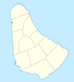
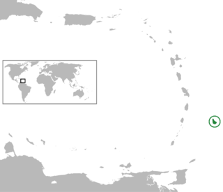
Barbados is an island country in the Lesser Antilles of the West Indies, in the Caribbean region of North America, and the most easterly of the Caribbean Islands. It is 34 kilometres in length and up to 23 km (14 mi) in width, covering an area of 432 km2 (167 sq mi). It is in the western part of the North Atlantic, 100 km (62 mi) east of the Windward Islands and the Caribbean Sea. Barbados is east of the Windwards, part of the Lesser Antilles, at roughly 13°N of the equator. It is about 168 km (104 mi) east of both the countries of Saint Lucia and Saint Vincent and the Grenadines and 180 km (110 mi) south-east of Martinique and 400 km (250 mi) north-east of Trinidad and Tobago. Barbados is outside the principal Atlantic hurricane belt. Its capital and largest city is Bridgetown.
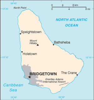
Barbados is a continental island in the North Atlantic Ocean and is located at 13°10' north of the equator, and 59°32' west of the Prime Meridian. As the easternmost isle of the Lesser Antilles in the West Indies, Barbados lies 160 kilometres (100 mi) east of the Windward Islands and Caribbean Sea. The maritime claim for Barbados is a territorial sea of 12 nmi, with an exclusive economic zone of 200 nmi which gives Barbados a total maritime area of 186,898 km2 (72,162 sq mi). Of the total EEZ area 70,000 km2, is set aside for offshore oil exploration. A pending application to UNCLOS has placed for consideration a continental shelf 200 nmi to the east and south. To the west, most of Barbados' maritime boundaries consist of median lines with neighbours. These neighbours include: Martinique, and Saint Lucia to the northwest, Saint Vincent and the Grenadines to the west, Trinidad and Tobago and Venezuela to the southwest, and Guyana to the southeast.
Hugh of Lincoln was an English boy whose death was falsely attributed to Jews. He is sometimes known as Little Saint Hugh or Little Sir Hugh to distinguish him from the adult saint, Hugh of Lincoln. The boy Hugh was never formally canonised, so properly "Little Saint Hugh" is a misnomer.

The parish of St. Michael is one of eleven parishes of Barbados. It has a land area of 39 km2 (15 sq mi) and is found at the southwest portion of the island. Saint Michael has survived by name as one of the original six parishes created in 1629 by Governor Sir William Tufton.

Saint Andrew is one of eleven parishes of Barbados. It is situated in the northern area in the country.

The parish of Saint James is an area located in the western central part of the country of Barbados. Increasingly St. James is becoming known as the playground of the rich and famous, and a haven for sun-starved tourists.

The parish of Saint Thomas is found in the centre of Barbados. It is one of only two landlocked parishes in the island, the other being Saint George to the south.

The peak of Mount Hillaby is the highest point on the Eastern Caribbean island of Barbados. The peak is located in the parish of Saint Andrew. It immediately overlooks the area known as the Scotland District to the north and east which comprises geologically old sediments prone to erosion.
Turners Hall Woods is a park and nature reserve in the parish of Saint Andrew in Barbados. Monkeys are abundant here, as are other unusual flora and fauna. The trail will lead you gradually uphill to a great location overlooking the sea on the rugged east coast of the island.
The following is an alphabetical list of topics related to the nation of Barbados.
The following outline is provided as an overview of and introduction to Barbados:

St. James Parish Church, is located in Holetown, St. James, Barbados. It stands on one of the oldest parcels of consecrated land on the island, often known in Barbados as "God's acre". Part of the Diocese of Barbados in the Church in the Province of the West Indies, St. James Parish Church is just north of Holetown, beside Folkstone Park.

Ryan Brathwaite is a track and field athlete from Barbados who won the gold medal in the 110 metres hurdles at the 2009 World Championships in Athletics in Berlin. In recognition of his achievements, on September 17, 2009 Brathwaite was given the honour of being an ambassador while formally receiving the title Ambassador His Excellency Ryan Brathwaite.

Golden Grove is a settlement in the parish of Saint Thomas, Jamaica. Historically a sugar plantation, it had a population of 3,057 in 2009.

The Leeward Islands Station and originally known as the Barbadoes and Leeward Islands Station was a formation or command of the Kingdom of Great Britain and then the United Kingdom's Royal Navy stationed at English Harbour, Antigua, Leeward Islands from 1743 to 1821.
Michael Ryan was one of seven children born to John Ryan, styled as the "Father of the Press in British North America", and Amelia Mott. Michael Ryan likely learned his trade as a printer, publisher, and editor at his father's feet. Early on in his career as a printer, he started two short-lived newspapers in Fredericton, Nova Scotia, and Saint John, New Brunswick. After the failure of these two papers, he worked briefly as a partner with his father on the first newspaper in Newfoundland. Likely eager to go off on his own he proposed a second paper for Newfoundland and was denied. Shortly after this he left Newfoundland for the Caribbean and edited, published and printed newspapers in Antigua and Barbados.

Saint Vincent and the Grenadines–Turkey relations are foreign relations between Saint Vincent and the Grenadines and Turkey.