
The Erie Canal is a canal in New York, United States that is part of the east–west, cross-state route of the New York State Canal System. Originally, it ran 363 miles (584 km) from the Hudson River in Albany to Lake Erie in Buffalo. It was built to create a navigable water route from New York City and the Atlantic Ocean to the Great Lakes. When completed in 1825, it was the second longest canal in the world and greatly enhanced the development and economy of New York, New York City, and the United States.
The Buckeye Trail is a 1,444-mile (2,324 km) hiking trail and long-distance trail that loops around the state of Ohio. Part of it is on roads and part is on wooded trail. Road portions of the trail are gradually being relocated to separate trail.

The Maumee River is a river running from northeastern Indiana into northwestern Ohio and Lake Erie in the United States. It is formed at the confluence of the St. Joseph and St. Marys rivers, where Fort Wayne, Indiana, has developed, and meanders northeastwardly for 137 miles (220 km) through an agricultural region of glacial moraines before flowing into the Maumee Bay of Lake Erie. The city of Toledo is located at the mouth of the Maumee. The Maumee was designated an Ohio State Scenic River on July 18, 1974. The Maumee watershed is Ohio’s breadbasket; it is two-thirds farmland, mostly corn and soybeans. It is the largest watershed of any of the rivers feeding the Great Lakes, and supplies five percent of Lake Erie’s water.

The Wabash and Erie Canal was a shipping canal that linked the Great Lakes to the Ohio River via an artificial waterway. The canal provided traders with access from the Great Lakes all the way to the Gulf of Mexico. Over 460 miles long, it was the longest canal ever built in North America.

The Great Miami River is a tributary of the Ohio River, approximately 160 miles (260 km) long, in southwestern Ohio and Indiana in the United States. The Great Miami flows through Dayton, Piqua, Troy, Hamilton, and Sidney.
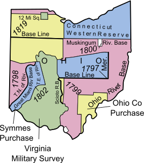
The Ohio Lands were the several grants, tracts, districts and cessions which make up what is now the U.S. state of Ohio. The Ohio Country was one of the first settled parts of the Midwest, and indeed one of the first settled parts of the United States beyond the original 13 colonies. The land that became first the anchor of the Northwest Territory and later Ohio was cobbled together from a variety of sources and owners.
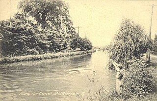
The Miami and Erie Canal was a 274-mile (441 km) canal that ran from Cincinnati to Toledo, Ohio, creating a water route between the Ohio River and Lake Erie. Construction on the canal began in 1825 and was completed in 1845 at a cost to the state government of $8,062,680.07. At its peak, it included 19 aqueducts, three guard locks, 103 canal locks, multiple feeder canals, and a few man-made water reservoirs. The canal climbed 395 feet (120 m) above Lake Erie and 513 feet (156 m) above the Ohio River to reach a topographical peak called the Loramie Summit, which extended 19 miles (31 km) between New Bremen, Ohio to lock 1-S in Lockington, north of Piqua, Ohio. Boats up to 80 feet long were towed along the canal by mules, horses, or oxen walking on a prepared towpath along the bank, at a rate of four to five miles per hour.

The Ohio and Erie Canal was a canal constructed during the 1820s and early 1830s in Ohio. It connected Akron with the Cuyahoga River near its outlet on Lake Erie in Cleveland, and a few years later, with the Ohio River near Portsmouth. It also had connections to other canal systems in Pennsylvania.

The Warren County Canal was a branch of the Miami and Erie Canal in southwestern Ohio about 20 miles (32 km) in length that connected the Warren County seat of Lebanon to the main canal at Middletown in the mid-19th century. Lebanon was at the crossroads of two major roads, the highway from Cincinnati to Columbus and the road from Chillicothe to the College Township (Oxford), but Lebanon businessmen and civic leaders wanted better transportation facilities and successfully lobbied for their own canal, part of the canal fever of the first third of the 19th century. The Warren County Canal was never successful, operating less than a decade before the state abandoned it.

This is a list of properties and districts in Ohio that are listed on the National Register of Historic Places. There are over 3,900 in total. Of these, 73 are National Historic Landmarks. There are listings in each of Ohio's 88 counties.
The Whitewater Canal, which was built between 1836 and 1847, spanned a distance of seventy-six miles and stretched from Lawrenceburg, Indiana on the Ohio River to Hagerstown, Indiana.

State Route 73 is an east–west state highway in the southern portion of the U.S. state of Ohio. Its western terminus is on U.S. Route 27 in Oxford at the intersection of SR 732. SR 73’s eastern terminus is in Portsmouth at US 23; this is also the southern terminus of SR 104, and the two state routes run concurrent for over 6 miles (9.7 km) from this point north. Once SR 73 enters Scioto County, it is designated as the Scenic Scioto Heritage Trail by the Ohio Department of Transportation.

Providence is a ghost town on the north side of the Maumee River in southern Providence Township, Lucas County, Ohio, United States, about 24 miles (39 km) southwest of Toledo. After suffering a destructive fire and a cholera epidemic in mid-19th century, the village was abandoned. In this period, canal traffic had also fallen off.

Miami–Erie Canal Site Historic District is a registered historic district near West Chester, Ohio, listed in the National Register of Historic Places on 1978-12-18. It contains 2 contributing buildings.
The Ohio to Erie Trail is a route for non-motorists that traverses the U.S. state of Ohio, from southwest to northeast. It is named for its endpoints, the Ohio River at Cincinnati and Lake Erie at Cleveland. The route largely consists of rail trails and other multi-use trails but also includes some on-road segments in anticipation of future segregated cycle facilities. The route as a whole is intended for bicyclists and hikers, while some trails along the route also permit equestrian and horse and buggy traffic.
This is a list of the National Register of Historic Places listings in Stark County, Ohio.

The Miami and Erie Canal Deep Cut is a well-preserved long section of the Miami and Erie Canal near Spencerville in western Ohio. The 6,600-foot (2,000 m) segment represents one of the major construction efforts of the canal; in order to avoid using locks to go over a ridge, the canal was dug deeply into it, far more than the 5-foot (1.5 m) depth of the canal itself. Workers dug the canal bed up to 52 feet (16 m) into the blue clay ridge that separated the St. Marys and Auglaize River watersheds. It is a United States National Historic Landmark. The cut is owned by the state and managed jointly by Johnny Appleseed MetroParks and the Heritage Trails Park District as Deep Cut Historical Park, with multi-use trails and a picnic area.
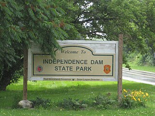
Independence Dam State Park is a 591-acre (239 ha) in Defiance County, Ohio in the United States. This Ohio state park lies on the banks of the Maumee River and features ruins of the Miami and Erie Canal. The park was established in 1949 and is open for year-round recreation including, boating, fishing, hiking and picnicking. It is off U.S. Route 24 just east of Defiance, Ohio.

The Lockington Locks are a group of canal locks on the former Miami and Erie Canal in Lockington, Ohio, United States. Built beginning in 1833, the locks opened for regular use in 1845. The system consists of seven locks: six together at one end, and a seventh at the southern end. Along with features such as basins to allow canal boats to turn around, the locks stretch for 3.75 miles (6.04 km) between Lockington in far southern Shelby County and Washington Township in far northern Miami County.

