The Cajuns, also known as Louisiana Acadians, are a Louisiana French ethnicity mainly found in the U.S. state of Louisiana and surrounding Gulf Coast states.

St. Martin Parish is a parish located in the U.S. state of Louisiana, founded in 1811. Its parish seat is St. Martinville, and the largest city is Breaux Bridge. At the 2020 census, the population was 51,767. St. Martin Parish is part of the Lafayette metropolitan area in the region of Acadiana, along the Gulf Coast.

St. Landry Parish is a parish located in the U.S. state of Louisiana. As of the 2020 Census, the population was 82,540. The parish seat is Opelousas. The parish was established in 1807.
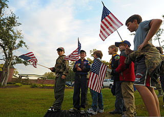
Scouting in Louisiana has a long history, from the 1910s to the present day, serving thousands of youth in programs that suit the environment in which they live.

Carencro is a city in Lafayette Parish, Louisiana, United States. It is a suburb of the nearby city of Lafayette. The population was 7,526 at the 2010 census, up from 6,120 in 2000; at the 2020 census, its population was 9,272. The name of the city is derived from the Cajun French word for buzzard; the spot where the community was settled was one where large flocks of American black vultures roosted in the bald cypress trees. The name means "carrion crow." Carencro is part of the Lafayette metropolitan area.

Lafayette is the most populous city in and parish seat of Lafayette Parish in the U.S. state of Louisiana, located along the Vermilion River. It is Louisiana's fourth-most populous city with a 2020 census population of 121,374; the consolidated city-parish's population was 241,753 in 2020. The Lafayette metropolitan area was Louisiana's third largest metropolitan statistical area with a population of 478,384 at the 2020 census. The Acadiana region containing Lafayette is the largest population and economic corridor between Houston, Texas and New Orleans.
Opelousas is a small city and the parish seat of St. Landry Parish, Louisiana, United States. Interstate 49 and U.S. Route 190 were constructed with a junction here. According to the 2020 census, Opelousas has a population of 15,786, a 6.53 percent decline since the 2010 census, which had recorded a population of 16,634. Opelousas is the principal city for the Opelousas-Eunice Micropolitan Statistical Area, which had an estimated population of 80,808 in 2020. Opelousas is also the fourth largest city in the Lafayette-Acadiana Combined Statistical Area, which has a population of 537,947.

Breaux Bridge is a small city in St. Martin Parish, Louisiana, United States. The population was 8,139 as of the 2010 census, up from 7,281 in 2000. By 2020, its population was 7,513. It is part of the Lafayette metropolitan statistical area.

St. Martinville is a city in and the parish seat of St. Martin Parish, Louisiana, United States. It lies on Bayou Teche, 13 miles (21 km) south of Breaux Bridge, 16 miles (26 km) southeast of Lafayette, and 9 miles (14 km) north of New Iberia. The population was 6,114 at the 2010 U.S. census, and 5,379 at the 2020 United States census. It is part of the Lafayette metropolitan statistical area.
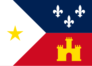
Acadiana, also known as the Cajun Country, is the official name given to the French Louisiana region that has historically contained much of the state's Francophone population.

The Atakapa or Atacapa were an Indigenous people of the Southeastern Woodlands, who spoke the Atakapa language and historically lived along the Gulf of Mexico in what is now Texas and Louisiana.

The Vermilion River is a 70.0-mile-long (112.7 km) bayou in southern Louisiana in the United States. It is formed on the common boundary of Lafayette and St. Martin parishes by a confluence of small bayous flowing from St. Landry Parish, and flows generally southward through Lafayette and Vermilion parishes, past the cities of Lafayette and Abbeville. At the port of Intracoastal City, the Gulf Intracoastal Waterway crosses the river before the latter flows into Vermilion Bay, an inlet of the Gulf of Mexico. The river originates at Bayou Fusilier, which is fed by Bayou Teche; winds its way through Lafayette Parish; and drains into the Vermilion Bay below Vermilion Parish.
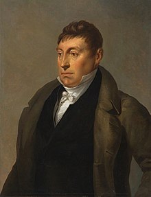
Joseph Broussard (1702–1765), also known as Beausoleil, was a leader of the Acadian people in Acadia; later Nova Scotia, Prince Edward Island, and New Brunswick. Broussard organized Mi'kmaq and Acadian militias against the British through King George's War, Father Le Loutre's War and during the Seven Years' War. After Acadia was captured by the British, he eventually led the first group of Acadians to southern Louisiana in the present-day United States. His name is sometimes presented as Joseph Gaurhept Broussard; this is likely the result of a transcription error. Broussard is widely regarded as a hero and an important historical figure by both Acadians and Cajuns.

Jean-Jacques-Alfred-Alexandre "Alfred" Mouton was a Confederate general in the American Civil War. Although trained at West Point, he soon resigned his commission to become a civil engineer and then a sugarcane grower, while also serving as a brigadier general in the Louisiana State Militia.

Bayou Queue de Tortue is a waterway in the Mermentau River basin of southern Louisiana in the United States. The bayou is 55 miles (89 km) long and is partly navigable.

The Cathedral of Saint John the Evangelist or La Cathédrale St-Jean, originally called l'Église St-Jean du Vermilion, is the cathedral and mother church of the Roman Catholic Diocese of Lafayette in Louisiana. It was the first parish in Lafayette Parish—founded in 1821—and was designated cathedral upon the erection of the diocese in 1918.

Attakapas Parish, a former parish (county) in southern Louisiana, was one of the twelve parishes in the Territory of Orleans, newly defined by the United States federal government following its Louisiana Purchase in 1803. At its core was the Poste des Attakapas trading post, which developed as the current city of St. Martinville.

Vermilionville Historic Village, located in Lafayette, Louisiana, is a Cajun and Creole living history museum with a combination of restored and replica historic structures.