Hittite rock reliefs

Last updated
Turkey adm location map.svg
Archaeological site icon (red).svg
Manisa
Archaeological site icon (red).svg
Hanyeri
Archaeological site icon (red).svg
Yazılıkaya
Archaeological site icon (red).svg
Fıraktın
Archaeological site icon (red).svg
Gökbez
Archaeological site icon (red).svg
İmamkullu
Archaeological site icon (red).svg
Hemite
Archaeological site icon (red).svg
Karabel
Archaeological site icon (red).svg
Taşçı
Extant Hittite rock reliefs in Turkey
The Ivriz relief (8th century BC), photographed 2001 IvrizRelief.JPG
The İvriz relief (8th century BC), photographed 2001

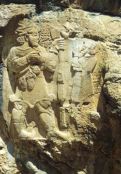
Rock reliefs form a large part of the extant artistic remains of the Anatolian Hittite Empire (c. 14th century BC). The reliefs that survive are often located near roads, and in mountainous terrain (over 1000 meters elevation) overlooking plains. They are often near sites with sacred significance both before and after the Hittite period, such as sacred springs, "linking the [Hittite] state's official discourse with the divine beings of [those] places" (Harmanşah 2014). [1]

Contents

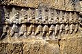
At Yazılıkaya, just outside the capital of Hattusa, a series of reliefs of Hittite gods in procession decorate open-air "chambers" made by adding barriers among the natural rock formations. The site was apparently a sanctuary, and possibly a burial site, for the commemoration of the ruling dynasty's ancestors.

Ancient references

Herodotus, in the Histories (written c. 430 BC), describes the Karabel relief, which he attributes to the legendary Egyptian pharaoh Sesostris:

Also, there are in Ionia two figures of this man [i.e., Sesostris] carved in rock, one on the road from Ephesus to Phocaea, and the other on that from Sardis to Smyrna. In both places, the figure is over twenty feet high, with a spear in his right hand and a bow in his left, and the rest of his equipment proportional; for it is both Egyptian and Ethiopian; and right across the breast from one shoulder to the other a text is cut in the Egyptian sacred characters, saying: “I myself won this land with the strength of my shoulders.” There is nothing here to show who he is and whence he comes, but it is shown elsewhere. Some of those who have seen these figures guess they are Memnon, but they are far indeed from the truth. [2]

List of reliefs

Related Research Articles

<span class="mw-page-title-main">Hittites</span> Ancient Anatolian people of Kussara

The Hittites were an Anatolian people who played an important role in establishing first a kingdom in Kussara, then the Kanesh or Nesha kingdom, and next an empire centered on Hattusa in north-central Anatolia. This empire reached its height during the mid-14th century BC under Šuppiluliuma I, when it encompassed an area that included most of Anatolia as well as parts of the northern Levant and Upper Mesopotamia.

<span class="mw-page-title-main">Ancient art</span> Art by advanced cultures of ancient societies

Ancient art refers to the many types of art produced by the advanced cultures of ancient societies with different forms of writing, such as those of ancient China, India, Mesopotamia, Persia, Palestine, Egypt, Greece, and Rome. The art of pre-literate societies is normally referred to as prehistoric art and is not covered here. Although some pre-Columbian cultures developed writing during the centuries before the arrival of Europeans, on grounds of dating these are covered at pre-Columbian art and articles such as Maya art, Aztec art, and Olmec art.

<span class="mw-page-title-main">Arzawa</span> Ancient kingdom in western Anatolia

Arzawa was a region and a political entity in Western Anatolia during the Late Bronze Age. This name was used in contemporary Hittite records to refer either to a single "kingdom" or a federation of local powers. The core of Arzawa is believed to be along the Kaystros River, with its capital at Apasa, later known as Ephesus. When the Hittites conquered Arzawa, it was divided into three Hittite provinces: a southern province called Mira along the Maeander River; a northern province called the Seha River Land, along the Gediz River; and an eastern province called Hapalla.

<span class="mw-page-title-main">Hattusa</span> Capital of the Hittite Empire

Hattusa was the capital, during two periods, of the Hittite Empire in the late Bronze Age. Its ruins lie near modern Boğazkale, Turkey, within great loop of the Kızılırmak River. Hattusa was added to the UNESCO World Heritage Site list in 1986.

<span class="mw-page-title-main">Archibald Sayce</span> British Assyriologist and linguist

The Rev. Archibald Henry Sayce was a pioneer British Assyriologist and linguist, who held a chair as Professor of Assyriology at the University of Oxford from 1891 to 1919. He was able to write in at least twenty ancient and modern languages, and was known for his emphasis on the importance of archaeological and monumental evidence in linguistic research. He was a contributor to articles in the 9th, 10th and 11th editions of the Encyclopædia Britannica.

<span class="mw-page-title-main">Sesostris</span> Sesostris III

Sesostris, also transliterated as Sesoösis, or Sesonchosis, is the name of a legendary king of ancient Egypt who, according to Herodotus, led a military expedition into parts of Europe. Tales of Sesostris are probably based on the life of Senusret I, Senusret III and perhaps other Pharaohs such as Sheshonq I and Ramesses II.

<span class="mw-page-title-main">Yazılıkaya</span> Capital city of the Hittite Empire

Yazılıkaya was a sanctuary of Hattusa, the capital city of the Hittite Empire, today in the Çorum Province, Turkey. Rock reliefs are a prominent aspect of Hittite art, and these are generally regarded as the most important group.

Kemalpaşa is a large town and the center of the district of the same name in İzmir Province, Turkey. Its district area extends immediately to the east of İzmir's easternmost metropolitan district, Bornova, and Kemalpaşa town being at a distance of only 29 km (18 mi) from the historical and traditional center of İzmir, (Konak), it pulsates along with the rhythm of the big city, with corresponding high levels of development in terms of industry and services. İzmir-Ankara highway crosses the district area 8 km (5.0 mi) to the north of the district center. Kemalpaşa district area borders on the administrative divisions of Manisa center in the north, Manisa's depending district of Turgutlu in the east and İzmir's depending districts of Torbalı and Bayındır in the south. The eastern and southern parts of Kemalpaşa district preserve their markedly rural characteristics, which results in an urbanization rate of only 25.7 for the district area as a whole, despite the presence of a strong industrial base in and to the west of Kemalpaşa town. Kemalpaşa's very large organized industrial zone (KOSBİ) brings together producers of construction materials, rubber and plastic goods, textiles and clothing, leather, paper, packaging materials, machinery and other equipment, including electrical tools and installations, dyes and other chemical substances, marble and car parts, as well as foundries and other metalworks. Agriculture also occupies a portion with high added value in Kemalpaşa's economy, its cherries being of nationwide renown and exported. Literacy is at a high level at 90%, and the neighboring Bornova, where Ege University is based, serves as a nearby pool in terms of trained personnel.

<span class="mw-page-title-main">Hittite sites</span>

The geography of the Hittite Empire is inferred from Hittite texts on the one hand, and from archaeological excavation on the other. Matching philology to archaeology is a difficult and ongoing task, and so far, only a handful of sites are identified with their ancient name with certainty.

<span class="mw-page-title-main">Mount Nif</span>

Mount Nif, Turkish: Nif Dağı, is a mountain in the district of Kemalpaşa, towering over the district center, located immediately to the east of the city of İzmir, in western Turkey. It was one of the nineteen mountains which carried the name Olympus in ancient times.

<span class="mw-page-title-main">Stelae of Nahr el-Kalb</span>

The commemorative stelae of Nahr el-Kalb are a group of over 20 inscriptions and rock reliefs carved into the limestone rocks around the estuary of the Nahr al-Kalb in Lebanon, just north of Beirut.

<span class="mw-page-title-main">Fıraktın relief</span>

The Hittite rock relief Fıraktın relief is located roughly 50 km south of Kayseri in the province of the same name in southern Turkey, at Fıraktın on the bank of the Enzel Dere, a tributary of the Zamantı Irmağı. Strabo called the place Dastarkon. Rock reliefs are a prominent aspect of Hittite art.

<span class="mw-page-title-main">Hanyeri relief</span> Settlement in Türkiye

The Hanyeri relief is a Hittite rock relief near Hanyeri on the road from Tufanbeyli to Develi in Tufanbeyli district in Adana Province, about 80 km southeast of Kayseri, in Turkey. In Hittite times, the route over the 1960 m high Gezbeli Pass through the Taurus Mountains, which connected the Hittite heartland on the Kızılırmak River with Cilicia, passed by here. At the other end of the pass, to the northwest, is the İmamkullu relief. Rock reliefs are a prominent aspect of Hittite art.

<span class="mw-page-title-main">İmamkullu relief</span> Rock relief near the town of İmamkullu, Kayseri Province, Turkey

The Hittite İmamkullu relief is a rock relief near the town of İmamkullu in Tomarza district in Kayseri Province, Turkey. In Turkish it is known as Yazılı Kaya and Şimşekkaya. Rock reliefs are a prominent aspect of Hittite art.

<span class="mw-page-title-main">Taşçı reliefs</span>

The two Taşçı reliefs are rock reliefs from the time of the Hittite empire. They are two kilometres south of Taşçı in Develi district, Kayseri Province, Turkey. They are known in Turkish as Yazılı Kaya. Rock reliefs are a prominent aspect of Hittite art.

<span class="mw-page-title-main">Manisa relief</span>

The Manisa relief, also known as the Akpınar relief and the Cybele relief, is a Hittite rock relief at Akpınar, about 5 km east of the Turkish provincial capital of Manisa above an amusement park on the road to Salihli. It depicts a Hittite divinity. Rock reliefs are a prominent aspect of Hittite art.

<span class="mw-page-title-main">Hemite relief</span> Hittite rock relief in Turkey

The Hemite relief is a Hittite rock relief at Gökçedam in the central district of Osmaniye Province in Turkey, about 20 km northwest of the provincial capital of Osmaniye. Rock reliefs are a prominent aspect of Hittite art.

<span class="mw-page-title-main">Karabel relief</span>

The Hittite / Luwian Karabel relief is a rock relief in the pass of the same name, between Torbalı and Kemalpaşa, about 20 km from Izmir in Turkey. Rock reliefs are a prominent aspect of Hittite art.

<span class="mw-page-title-main">Rock relief</span>

A rock relief or rock-cut relief is a relief sculpture carved on solid or "living rock" such as a cliff, rather than a detached piece of stone. They are a category of rock art, and sometimes found as part of, or in conjunction with, rock-cut architecture. However, they tend to be omitted in most works on rock art, which concentrate on engravings and paintings by prehistoric peoples. A few such works exploit the natural contours of the rock and use them to define an image, but they do not amount to man-made reliefs. Rock reliefs have been made in many cultures throughout human history, and were especially important in the art of the ancient Near East. Rock reliefs are generally fairly large, as they need to be in order to have an impact in the open air. Most of those discussed here have figures that are over life-size, and in many the figures are multiples of life-size.

<span class="mw-page-title-main">Hittite art</span>

Hittite art was produced by the Hittite civilization in ancient Anatolia, in modern-day Turkey, and also stretching into Syria during the second millennium BCE from the nineteenth century up until the twelfth century BCE. This period falls under the Anatolian Bronze Age. It is characterized by a long tradition of canonized images and motifs rearranged, while still being recognizable, by artists to convey meaning to a largely illiterate population.

“Owing to the limited vocabulary of figural types [and motifs], invention for the Hittite artist usually was a matter of combining and manipulating the units to form more complex compositions"

References

  1. Ömür Harmanşah (2014). "Event, Place, Performance: Rock Reliefs and Spring Monuments in Anatolia". In Ömür Harmanşah (ed.). Of Rocks and Water: Towards an Archaeology of Place. Oxford: Joukowsky Institute/Oxbow Books. p. 155. ISBN   978-1-78297-671-4.
  2. Herodotus (1920). Histories. Vol. 2.106. Translated by A. D. Godley. Cambridge: Harvard University.