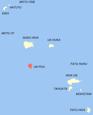
The commune of Hiva-Oa is made up of the island of Hiva Oa proper (316km2 (122sqmi)), which contains the entire population of the commune, and the uninhabited islands of:[4]
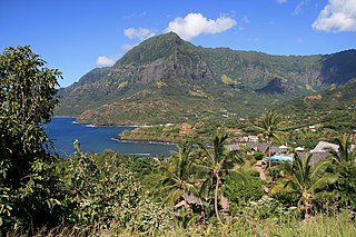
The administrative centre of the commune is the settlement of Atuona,[4] on the southern side of the island of Hiva Oa.
The Island is internationally perhaps best known as the place where the French and Belgian artists Paul Gauguin and Jacques Brel spent their final years and is their final resting place.
The Marquesas Islands are a group of volcanic islands in French Polynesia, an overseas collectivity of France in the southern Pacific Ocean. Their highest point is the peak of Mount Oave on Ua Pou island, at 1,230 m (4,035 ft) above sea level.
Atuona, located on Atuona Bay on the southern side of Hiva Oa island, French Polynesia, is the administrative centre of the commune (municipality) of Hiva-Oa. Atuona was the capital of all the Marquesas Islands but it has been replaced by Taioha'e.
Ua Pou is the third largest of the Marquesas Islands, in French Polynesia, an overseas territory of France in the Pacific Ocean.
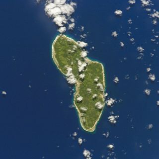
Tahuata is the smallest of the inhabited Marquesas Islands, in French Polynesia, an overseas territory of France in the Pacific Ocean. It is located 4 km (2.5 mi.) to the south of the western end of Hiva Oa, across the Canal du Bordelais, called Ha‘ava in Marquesan.
Rūrutu is the northernmost island in the Austral archipelago of French Polynesia, and the name of a commune consisting solely of that island. It is situated 572 km (355 mi) south of Tahiti. Its land area is 32.7 km2 (12.6 sq mi). It is 10.8 km long and 5.3 km wide. Its highest point (Manureva) is 389 m (1,276 ft). At the 2022 census it had a population of 2,163.
Pīraʻe is a commune in the suburbs of Papeʻete in French Polynesia, an overseas collectivity of France in the Pacific Ocean. Pīraʻe is located on the island of Tahiti, in the administrative subdivision of the Windward Islands, themselves part of the Society Islands. It borders Papeʻete in the west and Arue in the east. At the 2022 census it had a population of 14,068. The Stade Pater Te Hono Nui is a stadium located in the commune.
Arue is a commune in the suburbs of Papeete in French Polynesia, an overseas territory of France in the Pacific Ocean. Arue is located on the island of Tahiti, in the administrative subdivision of the Windward Islands, themselves part of the Society Islands. At the 2022 census it had a population of 10,322.
In French Polynesia, there are two levels of administrative divisions: five administrative subdivisions and 48 communes. Many of the communes are further subdivided into communes associées. The breakdown into administrative subdivisions was as a result of the law #71-1028, dated December 24, 1971. The compositions of the administrative subdivisions and the communes were defined in the decrees #72-408 and #72-407 of May 17, 1972, respectively. These subdivisions were confirmed in the decree #2005-1611 of December 20, 2005. Below are several lists of the divisions, according to different sorting schemes.
Paparā is a commune of French Polynesia, an overseas territory of France in the Pacific Ocean. Paparā is located on the island of Tahiti, in the administrative subdivision of the Windward Islands, themselves part of the Society Islands. At the 2022 census it had a population of 11,743.
Teva I Uta is a commune of French Polynesia, an overseas territory of France in the Pacific Ocean. The commune of Teva I Uta is located on the island of Tahiti, in the administrative subdivision of the Windward Islands, themselves part of the Society Islands. At the 2022 census it had a population of 10,837.
Hitiaʻa O Te Ra is a commune of French Polynesia, an overseas territory of France in the Pacific Ocean. The commune of Hitiaʻa O Te Ra is located on the island of Tahiti, in the administrative subdivision of the Windward Islands, themselves part of the Society Islands. At the 2022 census it had a population of 10,196.
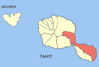
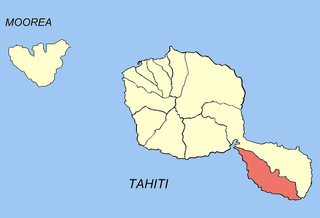
Taiʻarapu-Est is a commune of French Polynesia, an overseas territory of France in the Pacific Ocean. The commune of Taiʻarapu-Est is located on the island of Tahiti, in the administrative subdivision of the Windward Islands, themselves part of the Society Islands At the 2022 census it had a population of 13,602. The whole island of Mehetia is part of the commune.
Taiʻarapu-Ouest is a commune of French Polynesia, an overseas territory of France in the Pacific Ocean. The commune of Taiʻarapu-Ouest is located on the island of Tahiti, in the administrative subdivision of the Windward Islands, themselves part of the Society Islands. At the 2022 census it had a population of 8,371.
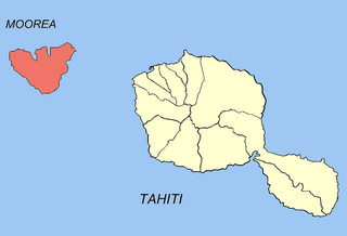
Moʻorea-Maiʻao is a commune of French Polynesia, an overseas territory of France in the Pacific Ocean. It consists of the island of Moʻorea and the much smaller atoll of Maiʻao, located 78 km (48 mi) southwest of Moʻorea, with both being part of the Windward Islands administrative subdivision. As of the 2022 census, Moorea-Maiao had a population of 18,201, of whom 17,858 lived on Mo'orea and 343 lived on Maiao.
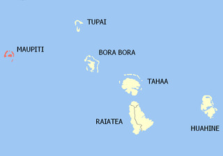
Maupiti is a commune of French Polynesia, an overseas territory of France in the Pacific Ocean. The commune is in the administrative subdivision of the Leeward Islands.
Arutua, or Ngaru-atua is an atoll in the Tuamotu group in French Polynesia. It is located 40 km SW of Rangiroa. The closest land is Apataki Atoll, only 16 km to the East.
Nuku-Hiva is a commune of French Polynesia, an overseas territory of France in the Pacific Ocean. The commune is in the administrative subdivision of the Marquesas Islands. Its population was 3,025 at the 2022 census.
Fakarava is a commune of French Polynesia in the archipelago of the Tuamotu Islands. The commune is in the administrative subdivision of the Îles Tuamotu-Gambier. The commune includes seven islands. The chef-lieu is the village Rotoava.
Gambier is a commune of French Polynesia in the administrative subdivision of the Tuamotu-Gambier Islands. The commune includes the Gambier Islands as well as several atolls in the Tuamotu Archipelago. All the Tuamotu atolls belonging to the commune are uninhabited except for Marutea Sud, and are sometimes mistakenly included among the Gambier Islands themselves. The commune population was 1,570 at the 2022 census. Its total land area is 45.97 km2.
Bora-Bora is a commune of French Polynesia, an overseas territory of France in the Pacific Ocean. The commune is in the administrative subdivision of the Leeward Islands. Its population was 10,758 at the 2022 census.
This page is based on this Wikipedia article Text is available under the CC BY-SA 4.0 license; additional terms may apply. Images, videos and audio are available under their respective licenses.