The Early Jurassic Epoch is the earliest of three epochs of the Jurassic Period. The Early Jurassic starts immediately after the Triassic–Jurassic extinction event, 201.3 Ma, and ends at the start of the Middle Jurassic 174.7 ±0.8 Ma.
The Hettangian is the earliest age and lowest stage of the Jurassic Period of the geologic timescale. It spans the time between 201.3 ± 0.2 Ma and 199.3 ± 0.3 Ma. The Hettangian follows the Rhaetian and is followed by the Sinemurian.

The Molasse basin is a foreland basin north of the Alps which formed during the Oligocene and Miocene epochs. The basin formed as a result of the flexure of the European plate under the weight of the orogenic wedge of the Alps that was forming to the south.

Radiolarite is a siliceous, comparatively hard, fine-grained, chert-like, and homogeneous sedimentary rock that is composed predominantly of the microscopic remains of radiolarians. This term is also used for indurated radiolarian oozes and sometimes as a synonym of radiolarian earth. However, radiolarian earth is typically regarded by Earth scientists to be the unconsolidated equivalent of a radiolarite. A radiolarian chert is well-bedded, microcrystalline radiolarite that has a well-developed siliceous cement or groundmass.
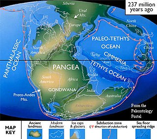
Cimmeria was an ancient continent, or, rather, a string of microcontinents or terranes, that rifted from Gondwana in the Southern Hemisphere and was accreted to Eurasia in the Northern Hemisphere. It consisted of parts of present-day Turkey, Iran, Afghanistan, Pakistan, Tibet, China, Myanmar, Thailand, and Malaysia. Cimmeria rifted from the Gondwanan shores of the Paleo-Tethys Ocean during the Early Permian and as the Neo-Tethys Ocean opened behind it, during the Permian, the Paleo-Tethys closed in front of it. Because the different chunks of Cimmeria drifted northward at different rates, a Meso-Tethys Ocean formed between the different fragments during the Cisuralian. Cimmeria rifted off Gondwana from east to west, from Australia to the eastern Mediterranean. It stretched across several latitudes and spanned a wide range of climatic zones.
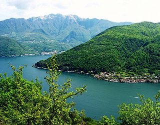
Monte San Giorgio is a Swiss mountain and UNESCO World Heritage Site near the border between Switzerland and Italy. It is part of the Lugano Prealps, overlooking Lake Lugano in the Swiss Canton of Ticino.
The Aquitaine Basin is the second largest Mesozoic and Cenozoic sedimentary basin in France after the Paris Basin, occupying a large part of the country's southwestern quadrant. Its surface area covers 66,000 km2 onshore. It formed on Variscan basement which was peneplained during the Permian and then started subsiding in the early Triassic. The basement is covered in the Parentis Basin and in the Subpyrenean Basin—both sub-basins of the main Aquitaine Basin—by 11,000 m of sediment.

Psiloceras is an extinct genus of ammonite. Psiloceras is among the earliest known Jurassic ammonites, and the appearance of the earliest Psiloceras species form the definition for the base of the Jurassic. Unlike most earlier ammonites, which had complex shell shapes and ornamentation, Psiloceras had a smooth shell.

The Pyrenees are a 430-kilometre-long, roughly east–west striking, intracontinental mountain chain that divide France, Spain, and Andorra. The belt has an extended, polycyclic geological evolution dating back to the Precambrian. The chain's present configuration is due to the collision between the microcontinent Iberia and the southwestern promontory of the European Plate. The two continents were approaching each other since the onset of the Upper Cretaceous (Albian/Cenomanian) about 100 million years ago and were consequently colliding during the Paleogene (Eocene/Oligocene) 55 to 25 million years ago. After its uplift, the chain experienced intense erosion and isostatic readjustments. A cross-section through the chain shows an asymmetric flower-like structure with steeper dips on the French side. The Pyrenees are not solely the result of compressional forces, but also show an important sinistral shearing.
The Ruhpolding Formation is a sedimentary formation of the Northern Calcareous Alps deposited during the Upper Jurassic. The open marine radiolarite is very rich in silica.
This list, 2013 in molluscan paleontology, is a list of new taxa of ammonites and other fossil cephalopods, as well as fossil gastropods, bivalves and other molluscs that have been described during the year 2013.
The Gabbs Formation is a geologic formation in Nevada. It preserves fossils dating back to the Late Triassic and Early Jurassic periods, and is one of the few formations in the United States known to include the Triassic-Jurassic boundary. In 2007, an exposure of the Gabbs Formation at New York Canyon was proposed a candidate GSSP for the Hettangian stage, the first stage of the Jurassic. However, the New York Canyon section was ultimately not selected as Hettangian GSSP, which instead went to the Kuhjoch section of Austria in 2010.

The Wetterstein Formation is a regional geologic formation of the Northern Limestone Alps and Western Carpathians extending from southern Bavaria, Germany in the west, through northern Austria to northern Hungary and western Slovakia in the east. The formation dates back to the Ladinian to Carnian stages of the Late Triassic. The formation is named after the Wetterstein Mountains in southern Germany and northwestern Austria. The center of its distribution, however, is in the Karwendel Mountains. It occurs in the Northern and Southern Limestone Alps and in the Western Carpathians.
The Kössen Formation is a Late Triassic (Rhaetian-age) geological formation in the Northern Calcareous Alps of Austria and Germany, in the Tiroler-Lech Nature Park. During the Late Triassic, the area now occupied by the Northern Calcareous Alps was instead a long, passive coastline at the western tip of the Neotethys Ocean. The environment was initially dominated by a wide and shallow carbonate platform within a lagoon between the shore and a string of reefs. This carbonate platform is nowadays preserved as the Carnian to Norian-age Hauptdolomit and Dachstein Formation. The Kössen Formation represents a period of increased siliciclastic clay input into the lagoon, covering up the carbonate platform with marls and marly limestones instead of pure limestone or dolomite. The Eiberg Member of the Kössen Formation was deposited in the Eiberg basin, a narrow strip of deeper water which developed between the carbonate platform and the shoreline in the later part of the Rhaetian.
The Kendlbach Formation is a Late Triassic to Early Jurassic (Hettangian) geological formation in Austria and Italy. It contains the Global Boundary Stratotype Section and Point (GSSP) for the Hettangian stage at the Kuhjoch section in the Karwendel Mountains of Austria.

The geology of Germany is heavily influenced by several phases of orogeny in the Paleozoic and the Cenozoic, by sedimentation in shelf seas and epicontinental seas and on plains in the Permian and Mesozoic as well as by the Quaternary glaciations.

The geology of Bosnia & Herzegovina is the study of rocks, minerals, water, landforms and geologic history in the country. The oldest rocks exposed at or near the surface date to the Paleozoic and the Precambrian geologic history of the region remains poorly understood. Complex assemblages of flysch, ophiolite, mélange and igneous plutons together with thick sedimentary units are a defining characteristic of the Dinaric Alps, also known as the Dinaride Mountains, which dominate much of the country's landscape.

The Rotzo Formation is a geological formation in Italy, dating to roughly between 192 and 186 million years ago and covering the Pliensbachian stage of the Jurassic Period in the Mesozoic Era. Has been traditionally classified as a Sinemurian-Pliensbachian Formation, but a large and detailed dataset of isotopic 13C and 87Sr/86Sr data, estimated the Rotzo Formation to span only over the Early Pliensbachian, bracketed between the Jamesoni-Davoei biozones, marked in the Loppio Oolitic Limestone–Rotzo Fm contact by a carbon isotope excursion onset similar to the Sinemu-Pliens boundary event, while the other sequences fit with the a warm phase that lasts until the Davoei biozone. The Rotzo Formation represented the Carbonate Platform, being located over the Trento Platform and surrounded by the Massone Oolite, the Fanes Piccola Encrinite, the Lombadian Basin Medolo Group and Belluno Basin Soverzene Formation, and finally towards the south, deep water deposits of the Adriatic Basin. The also Pliensbachian Aganane Formation of Morocco represents a regional equivalent, both in deposition and faunal content.

The Budoš Limestone is a geological formation in Montenegro, dating to 180 million years ago, and covering the Toarcian stage of the Jurassic Period. It has been considered an important setting in Balkan paleontology, as it represents a unique terrestrial setting with abundant plant material, one of the few know from the Toarcian of Europe. It is the regional equivalent to the Toarcian units of Spain such as the Turmiel Formation, units like the Azilal Formation of Morocco and others from the Mediterranean such as the Posidonia Beds of Greece and the Marne di Monte Serrone of Italy. In the Adriatic section, this unit is an equivalent of the Calcare di Sogno of north Italy, as well represents almost the same type of ecosystem recovered in the older (Pliensbachian) Rotzo Formation of the Venetian region, know also for its rich floral record.

Oncodella is an extinct genus of Late Triassic conodont. The genus was given the type species Oncodella idiodentica by Mosher (1968), on the basis of fossils from the Late Triassic of Austria. However, Mosher (1969) later revised the species name to Oncodella paucidentata, since identical fossils from the same area were previously given the name Hindeodella paucidentata by Mostler (1967).
