
The Last Glacial Period (LGP), also known colloquially as the last ice age or simply ice age, occurred from the end of the Eemian to the end of the Younger Dryas, encompassing the period c. 115,000 – c. 11,700 years ago. The LGP is part of a larger sequence of glacial and interglacial periods known as the Quaternary glaciation which started around 2,588,000 years ago and is ongoing. The definition of the Quaternary as beginning 2.58 million years ago (Mya) is based on the formation of the Arctic ice cap. The Antarctic ice sheet began to form earlier, at about 34 Mya, in the mid-Cenozoic. The term Late Cenozoic Ice Age is used to include this early phase.
The National Topographic System or NTS is the system used by Natural Resources Canada for providing general purpose topographic maps of the country. NTS maps are available in a variety of scales, the standard being 1:50,000 and 1:250,000 scales. The maps provide details on landforms and terrain, lakes and rivers, forested areas, administrative zones, populated areas, roads and railways, as well as other man-made features. These maps are currently used by all levels of government and industry for forest fire and flood control, depiction of crop areas, right-of-way, real estate planning, development of natural resources and highway planning. To add context, land area outside Canada is depicted on the 1:250,000 maps, but not on the 1:50,000 maps.

The Würm glaciation or Würm stage, usually referred to in the literature as the Würm, was the last glacial period in the Alpine region. It is the youngest of the major glaciations of the region that extended beyond the Alps themselves. Like most of the other ice ages of the Pleistocene epoch, it is named after a river, in this case the Würm in Bavaria, a tributary of the Amper. The Würm ice age can be dated to about 115,000 to 11,700 years ago, but sources differ about the dates, depending on whether the long transition phases between the glacials and interglacials are allocated to one or other of those periods. The average annual temperatures during the Würm ice age in the Alpine Foreland were below −3 °C. That has been determined from changes in the vegetation, as well as differences in the facies.

The Berliner Zeitung is a daily newspaper based in Berlin, Germany. It was founded in East Germany in 1945 and continued publication after reunification.

Propyl acetate, also known as propyl ethanoate, is an organic compound. Nearly 20,000 tons are produced annually for use as a solvent. This colorless liquid is known by its characteristic odor of pears. Due to this fact, it is commonly used in fragrances and as a flavor additive. It is formed by the esterification of acetic acid and 1-propanol, often via Fischer–Speier esterification, with sulfuric acid as a catalyst and water produced as a byproduct.
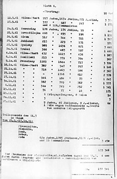
The so-called Jäger Report, also Jaeger Report was written on 1 December 1941 by Karl Jäger, commander of Einsatzkommando 3, a killing unit of Einsatzgruppe A which was attached to Army Group North during the Operation Barbarossa. It is the most detailed and precise surviving chronicle of the activities of one individual Einsatzkommando, and a key record documenting the Holocaust in Lithuania as well as in Latvia and Belarus.

The Field Elm cultivar Ulmus minor 'Christine Buisman' was the first cultivar released by the Dutch elm breeding programme, initiated in response to the less virulent form of Dutch elm disease (DED), Ophiostoma ulmi, which afflicted Europe's elms after the First World War. 'Christine Buisman' was selected from a batch of 390 seedlings grown from seed collected in the Parque de la Quinta de la Fuente del Berro, Madrid, by Mrs Van Eeghen, a friend of elm researcher Johanna Westerdijk, in 1929 and named for the elm disease researcher Christine Buisman. Originally identified as Ulmus foliacea, it was later treated as Ulmus × hollandica by Melville. However, more recent research in Belgium using DNA markers has reaffirmed 'Christine Buisman' as a clone of U. minor.
Various measures of paper quantity have been and are in use. Although there are no S.I. units such as quires and bales, there are ISO and DIN standards for the ream. Expressions used here include U.S. Customary Units.
Numbers is a spreadsheet application developed by Apple Inc. as part of the iWork productivity suite alongside Keynote and Pages. Numbers is available for iOS and macOS High Sierra or newer. Numbers 1.0 on OS X was announced on 7 August 2007, making it the newest application in the iWork suite. The iPad version was released on 27 January 2010. The app was later updated to support iPhone and iPod Touch.

The Weichselian glaciation was the last glacial period and its associated glaciation in northern parts of Europe. In the Alpine region it corresponds to the Würm glaciation. It was characterized by a large ice sheet that spread out from the Scandinavian Mountains and extended as far as the east coast of Schleswig-Holstein, the March of Brandenburg and Northwest Russia. This glaciation is also known as the Weichselian ice age, Vistulian glaciation, Weichsel or, less commonly, the Weichsel glaciation, Weichselian cold period (Weichsel-Kaltzeit), Weichselian glacial (Weichsel-Glazial), Weichselian Stage or, rarely, the Weichselian complex (Weichsel-Komplex).

The Feuerstein is a twin peak in the Stubai Alps on the border of Tyrol and South Tyrol.

The Äußerer Bärenbartkogel is a mountain in the Planeil group of the Ötztal Alps in South Tyrol, Italy.
The Hochfeiler is a mountain, 3,510 metres high, and the highest peak in the Zillertal Alps on the border between Tyrol, Austria, and South Tyrol, Italy.

A map series is a group of topographic or thematic charts or maps usually having the same scale and cartographic specifications, and with each sheet appropriately identified by its publisher as belonging to the same series.
The Kloppstert is a hill, roughly 553 metres high, in the southwestern Harz in Lower Saxony, Germany. In the topographical map printed in 1978 it can only be made out with difficulty that the third letter is an o and the penultimate one an r. Unfortunately a contour line runs over the letter r so that it looks like a p. In the digitalised 1:25,000 topographic map, the hill is wrongly named as the Klappstept.

The Fliegende Blätter was a German weekly humor and satire magazine appearing between 1845 and 1944 in Munich. Many of the illustrations were by well-known artists such as Wilhelm Busch, Count Franz Pocci, Hermann Vogel, Carl Spitzweg, Julius Klinger, Edmund Harburger, Adolf Oberländer and others. It was published by Verlag Braun & Schneider, a company belonging to the wood engraver Kaspar Braun and illustrator Friedrich Schneider. Aimed at the German bourgeoisie, it reached a maximum circulation of c.95,000 copies by 1895. It merged in 1928 with a competitor, the Meggendorfer-Blätter and was published until 1944 as Fliegende Blätter und Meggendorfer-Blätter by the Schreiber-Verlag in Esslingen am Neckar.

The Rainerhorn is a mountain in the Venediger Group. It is 3,559 m (11,677 ft) high.
An alpentor in geology is the point where an entire glacier forced its way through to the Alpine Foreland from the Alps during the ice age.

The Daniel is a mountain in the Austrian state of Tyrol, and the highest peak in the Ammergau Alps, a range within the Northern Limestone Alps . Located near the villages of Ehrwald and Lermoos, it is a popular mountain with hikers. Its North Face is around 200 metres high and its South Face has a more schrofen-like character. With the almost equally high Upsspitze (2,332 m) it forms a double summit. To the northwest is a neighbouring peak, the Hochschrutte (2,247 m).

Bronshtein and Semendyayev is the informal name of a comprehensive handbook of fundamental working knowledge of mathematics and table of formulas originally compiled by the Russian mathematician Ilya Nikolaevich Bronshtein and engineer Konstantin Adolfovic Semendyayev.
