Hoffland

Last updated
Hoffland

Hovland
Village
Norway More og Romsdal location map.svg
Red pog.svg
Hoffland
Location in Møre og Romsdal
Norway location map.svg
Red pog.svg
Hoffland
Hoffland (Norway)
Coordinates: 62°29′38″N06°11′40″E / 62.49389°N 6.19444°E / 62.49389; 6.19444 Coordinates: 62°29′38″N06°11′40″E / 62.49389°N 6.19444°E / 62.49389; 6.19444
Country Norway
Region Western Norway
County Møre og Romsdal
District Sunnmøre
Municipality Ålesund Municipality
Area
[1]
  Total0.31 km2 (0.12 sq mi)
Elevation
[2]
20 m (70 ft)
Population
(2013) [1]
  Total662
  Density2,135/km2 (5,530/sq mi)
Time zone UTC+01:00 (CET)
  Summer (DST) UTC+02:00 (CEST)
Post Code
6057 Ellingsøy

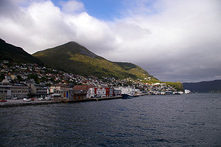
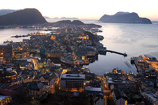
Hoffland or Hovland is a village in Ålesund Municipality in Møre og Romsdal county, Norway. The village is located on the western end of the island of Ellingsøya, about 3 kilometres (1.9 mi) northeast of the town of Ålesund and about 5 kilometres (3.1 mi) west of the village of Myklebost. [3]

Møre og Romsdal County (fylke) of Norway

Møre og RomsdalUrban East Norwegian: [²møːrə ɔ ˈrʊmsdɑːl](listen) is a county in the northernmost part of Western Norway. It borders the counties of Trøndelag, Oppland, and Sogn og Fjordane. The county administration is located in the town of Molde, while Ålesund is the largest town. The county is governed by the Møre og Romsdal County Municipality which includes an elected county council and a county mayor. The national government is represented by the county governor.

Norway constitutional monarchy in Northern Europe

Norway, officially the Kingdom of Norway, is a Nordic country in Northwestern Europe whose territory comprises the western and northernmost portion of the Scandinavian Peninsula; the remote island of Jan Mayen and the archipelago of Svalbard are also part of the Kingdom of Norway. The Antarctic Peter I Island and the sub-Antarctic Bouvet Island are dependent territories and thus not considered part of the kingdom. Norway also lays claim to a section of Antarctica known as Queen Maud Land.

Ellingsøy island in Ålesund Municipality, Norway

Ellingsøy or Ellingsøya is the northernmost island in Ålesund Municipality in Møre og Romsdal county, Norway. With an area of 22 square kilometres (8.5 sq mi), Ellingsøy is the second largest island in the municipality after Uksenøya. The island is located northeast of the town of Ålesund, north of the islands of Nørvøya and Uksenøya, east of the island of Valderøya, and south of the mainland peninsula of Haram. The villages of Hoffland, Årset, and Myklebust are all located on the south side of the island. Ellingsøy Church is the main church for the island.

The 0.31-square-kilometre (77-acre) village has a population (2013) of 662, giving the village a population density of 2,135 inhabitants per square kilometre (5,530/sq mi). [1] It is located at the entrance to two undersea tunnels. The Ellingsøy Tunnel leads to the city of Ålesund on the nearby island of Nørvøya and the Valderøy Tunnel leads to the island of Valderøya in neighboring Giske Municipality.

Population density A measurement of population numbers per unit area or volume

Population density is a measurement of population per unit area or unit volume; it is a quantity of type number density. It is frequently applied to living organisms, and most of the time to humans. It is a key geographical term. In simple terms population density refers to the number of people living in an area per kilometer square.

An undersea tunnel is a tunnel which is partly or wholly constructed under a body of water. They are often used where building a bridge or operating a ferry link is impossible, or to provide competition or relief for existing bridges or ferry links.

The Ellingsøy Tunnel is a subsea road tunnel in Ålesund Municipality in Møre og Romsdal county, Norway. The tunnel runs between the center of the city of Ålesund on the island of Nørvøya and the village of Hoffland on the island of Ellingsøya. The 3,481-metre (11,421 ft) long tunnel runs under the Ellingsøyfjorden and it is part of National Road 658 and it was constructed as part of the Vigra Fixed Link project which connected several outlying islands to the city of Ålesund and the mainland of Norway. The tunnel opened in 1987 and it was a toll road until 25 October 2009. The 3-lane tunnel has a vertical clearance of 4.6 metres (15 ft) and it reaches a depth of 140 metres (460 ft) below sea level. The steepest parts of the tunnel do not exceed an 8.5% grade. The Ellingsøy Tunnel has a 'cork screw' spiral under the Hoffland island to span vertical height.

Ole Brunes, a native of Hoffland, was among a group of fishermen of primarily Scandinavian ancestry who in the late 1880s founded the community of Hovland, Minnesota which he named for his Norwegian place of origin. Of similar origin is also the community of Hoffland, Nebraska.

Hovland, Minnesota Unincorporated community in Minnesota, United States

Hovland is an unincorporated community in Cook County, Minnesota, United States.

Hoffland, Nebraska Unincorporated community in Nebraska, United States

Hoffland is an unincorporated community in Sheridan County, Nebraska, in the United States.

Related Research Articles

Giske Municipality in Møre og Romsdal, Norway

Giske is an island municipality in Møre og Romsdal county, Norway. The municipality lies north-northwest of the town of Ålesund in the traditional district of Sunnmøre. The municipal centre is Valderhaugstrand. Other population centres include the villages of Roald and Alnes and Leitebakk. The municipality is part of the Ålesund Region.

Måløy Town in Western Norway, Norway

Måløy is a town and the administrative centre of the municipality of Vågsøy in Sogn og Fjordane county, Norway. Måløy is located on the southeastern side of the island of Vågsøy, about 3 kilometres (1.9 mi) northeast of the village of Holvika and about 6 kilometres (3.7 mi) south of the village of Raudeberg. The Måløy Bridge connects the town centre to the area of Deknepollen on the mainland. Sør-Vågsøy Church is located in Måløy.

Ulsteinvik Town in Western Norway, Norway

Ulsteinvik  is the commercial and administrative centre of the municipality (kommune) of Ulstein in Møre og Romsdal county, Norway. The 4.26-square-kilometre (1,050-acre) village has a population (2014) of 6,201; giving the village a population density of 1,456 inhabitants per square kilometre (3,770/sq mi). As such, Ulsteinvik contains 74% of the population of Ulstein Municipality. The town of Ulsteinvik is located on the west side of the island of Hareidlandet, about 23 kilometres (14 mi) southwest of the city of Ålesund. Ulstein Church is located in the town, serving the population of the whole municipality.

Nordfjordeid Village in Western Norway, Norway

Nordfjordeid is the administrative centre of the municipality of Eid in Sogn og Fjordane county, western Norway. It is located at the end of the Eidsfjorden, an arm off of the main Nordfjorden, west of the large lake Hornindalsvatnet. The village of Stårheim is located about 12 kilometres (7.5 mi) to the west, the village of Mogrenda is about 5 kilometres (3.1 mi) to the east, and the village of Lote is about 7 kilometres (4.3 mi) to the southeast.

Roald Village in Western Norway, Norway

Roald is a village in Giske Municipality in Møre og Romsdal county, Norway. The village is located on the northern part of the island Vigra. Roald is about 20 kilometres (12 mi) north of the city centre of Ålesund, connected via two undersea tunnels which opened in 1987. Ålesund Airport, Vigra is 2 kilometres (1.2 mi) south of the village of Roald. Vigra Church is located a short distance south of Roald.

Valle, Møre og Romsdal Village in Western Norway, Norway

Valle is a village in Skodje Municipality in Møre og Romsdal county, Norway. The village is located on the eastern end of the island of Oksenøya, along the northern shore of the Storfjorden. Valle sits along the European route E39/European route E136 highway, about 5 kilometres (3.1 mi) south of the municipal center of Skodje, 28 kilometres (17 mi) east of the city of Ålesund, and 11 kilometres (6.8 mi) west of Sjøholt in Ørskog Municipality.

Myklebost, Ålesund Village in Western Norway, Norway

Myklebost or Myklebust is a village in Ålesund Municipality in Møre og Romsdal county, Norway. It is located on the south side of the island of Ellingsøya, about 4 kilometres (2.5 mi) west of the village of Årset and about 5 kilometres (3.1 mi) east of the village of Hoffland. Myklebost is about 10 kilometres (6.2 mi) northeast of the city center of Ålesund.

Sjøholt Village in Western Norway, Norway

Sjøholt is the administrative centre of Ørskog Municipality in Møre og Romsdal county, Norway. The village is located along the northern shore of the Storfjorden, about 10 kilometres (6.2 mi) east of the village of Skodje. The village of Stordal is located about 18 kilometres (11 mi) to the south, through several tunnels. Sjøholt is located roughly halfway between the towns of Ålesund and Molde, along European route E39 and European route E136.

Fiskåbygd Village in Western Norway, Norway

Fiskåbygd or Fiskå is a coastal village that is also the administrative centre of Vanylven Municipality in Møre og Romsdal county, Norway. The village is located about 100 kilometres (62 mi) southwest of the city of Ålesund, about 12 kilometres (7.5 mi) east of the village of Myklebost, and about 30 kilometres (19 mi) southwest of the village of Rovdane. Fiskåbygd lies along the shores of the Vanylvsfjorden, east of the Stadlandet peninsula in Selje Municipality.

Sagvåg Village in Western Norway, Norway

Sagvåg is a village in Stord municipality in Hordaland county, Norway. The village is located on the southwest coast of the island of Stord, about 5 kilometres (3.1 mi) west of the town of Leirvik. The Stord Airport, Sørstokken lies about 2 kilometres (1.2 mi) northwest of Sagvåg. Nysæter Church was built here in 1991 to serve the population of the village. The small mining village of Litlabø lies just northeast of Sagvåg.

Nørvøya island in Ålesund, Norway

Nørvøya is an island in Ålesund Municipality in Møre og Romsdal county, Norway. It is the largest of the islands containing the city center of Ålesund, the others being Aspøya and Heissa, located to the west. The 5-square-kilometre (1.9 sq mi) island of Nørvøya is located south of Ellingsøya, north of Sula, and west of Oksenøya.

Ålesund Municipality in Møre og Romsdal, Norway

Ålesund is a town and municipality in Møre og Romsdal County, Norway. It is part of the traditional district of Sunnmøre and the centre of the Ålesund Region. It is a sea port and is noted for its concentration of Art Nouveau architecture. The town of Ålesund is the administrative centre of Ålesund Municipality, as well as the principal shipping town of the Sunnmøre district.

Oksenøya island in Norway

Oksenøya or Uksenøya is an island in the Sunnmøre region of Møre og Romsdal county, Norway. The island is divided between Ålesund Municipality and Skodje Municipality on the north side of the Storfjorden. Oksenøya has an area of 108 square kilometres (42 sq mi). The Ålesund half of the island is home to about 26,000 people, the Skodje side about 1,200. This is the largest island in Ålesund Municipality.

Brusdalsvatnet is a large lake on the island of Oksenøya in Møre og Romsdal county, Norway. The lake sits on the border between Ålesund Municipality and Skodje Municipality. The lake is a reservoir that is the water supply for the nearby city of Ålesund. The 7.3-square-kilometre (2.8 sq mi) lake is about 9.5 by 1.3 kilometres.

Årset, Ålesund Village in Western Norway, Norway

Årset is a village in Ålesund Municipality in Møre og Romsdal county, Norway. The village is located along the Ellingsøyfjorden on the southern shore of the island of Ellingsøya, about 4 kilometres (2.5 mi) east of the village of Myklebost and about 12 kilometres (7.5 mi) west of the village of Tennfjord in Haram Municipality.

Selje (village) Village in Western Norway, Norway

Selje is the administrative centre of Selje Municipality in Sogn og Fjordane county, Norway. The village is located at the southwestern base of the Stadlandet peninsula at the entrance to the Moldefjorden. The village lies about 17 kilometres (11 mi) northeast of the town of Måløy and about 65 kilometres (40 mi) southwest of the town of Ålesund. The small island of Selja lies just off the coast of the village. The 0.65-square-kilometre (160-acre) village has a population (2013) of 651, giving the village a population density of 1,002 inhabitants per square kilometre (2,600/sq mi). Selje Church is located in the village.

Eikefjord (village) Village in Western Norway, Norway

Eikefjord is a village in Flora Municipality in Sogn og Fjordane county, Norway. The village is located at the end of the Eikefjorden along the Norwegian National Road 5 highway. The town of Florø lies about 30 kilometres (19 mi) to the west and the village of Naustdal lies about 20 kilometres (12 mi) to the southeast (through the Naustdal Tunnel. The lake Endestadvatnet lies about 5 kilometres to the east. The villages of Nyttingnes and Steinhovden lie about 15 kilometres west of Eikefjord. The 0.4-square-kilometre village has a population of 368, giving the village a population density of 920 inhabitants per square kilometre.

Sæbøvik Village in Western Norway, Norway

Sæbøvik is a village in Kvinnherad municipality in Hordaland county, Norway. The village is located on the narrow, western part of the island of Halsnøya, about 6 kilometres (3.7 mi) west of the village of Høylandsbygd and immediately east of the village of Eidsvik. The village is located at the southern end of the Halsnøy Tunnel.

References

  1. 1 2 3 Statistisk sentralbyrå (1 January 2013). "Urban settlements. Population and area, by municipality".
  2. "Hovland" (in Norwegian). yr.no . Retrieved 2010-10-03.
  3. Store norske leksikon. "Hoffland" (in Norwegian). Retrieved 2010-10-03.