The Front Range is a mountain range of the Southern Rocky Mountains of North America located in the central portion of the U.S. State of Colorado, and southeastern portion of the U.S. State of Wyoming. It is the first mountain range encountered as one goes westbound along the 40th parallel north across the Great Plains of North America.

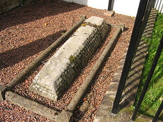
Hogbacks are stone carved Anglo-Scandinavian sculptures from 10th- to 12th-century northern England and south-west Scotland. Singular hogbacks were found in Ireland and Wales. Hogbacks fell out of fashion by the beginning of the 11th century. Their function is generally accepted as grave markers. Similar later grave markers have been found in Scandinavia. In Cornwall similar stones are known as coped stones.

A dip slope is a topographic (geomorphic) surface which slopes in the same direction, and often by the same amount, as the true dip or apparent dip of the underlying strata. A dip slope consists of the upper surface of a resistant layer of rock, often called caprock, that is commonly only slightly lowered and reduced in steepness by erosion. Dip slopes form the backslopes of cuestas, homoclinal ridges, hogbacks, and flatirons. The frontslopes of such ridges consist of either an escarpment, a steep slope, or perhaps even a line of cliffs. Generally, cuestas and homoclinal ridges are asymmetrical in that their dip slopes are less steep than their escarpments. In the case of hogbacks and flatirons, the dip of the rocks is so steep that their dip slope approaches the escarpment in their steepness.

Elliott Knob is one of the highest mountains in the northern portions of the U.S. state of Virginia. At 4,463 ft (1,360 m), the peak is located on the ridge known as Great North Mountain. A subpeak known simply as "Hogback" is located 0.5 mi (0.80 km) to the southwest. A small, naturally growing stand of red spruce trees is on the summit, and the upper slopes also have yellow birch and sugar maple, indicating that the altitude is just high enough to support tree species normally found hundreds of miles to the north. Otherwise oak and hickory trees are the most common types found on the mountain. The mountain is entirely within George Washington and Jefferson National Forests.

The Dakota Hogback is a long hogback ridge at the eastern fringe of the Rocky Mountains that extends north-south from southern Wyoming through Colorado and into northern New Mexico in the United States. The ridge is prominently visible as the first line of foothills along the edge of the Great Plains. It is generally faulted along its western side, and varies in height, with gaps in numerous locations where rivers exit the mountains. The ridge takes its name from the Dakota Formation, a formation with resistant sandstone beds that cap the ridge. The hogback was formed during the Laramide orogeny, approximately 50 million years ago, when the modern Rockies were created. The general uplift to the west created long faulting in the North American Plate, resulting in the creation of the hogback.

In Nordic mythology, Austri, Vestri, Norðri and Suðri ; are four dwarfs who hold up the sky after it was made by the gods from the skull of the jötunn Ymir. They are referred to both in Gylfaginning in the Prose Edda and in kennings. They have been further linked to dvergar ("dwarfs"), supports for the main beam of some halls, that are likely named due to the roof being seen as a reflection of the sky in Old Nordic religion.

The Camelsfoot Range is a sub-range of the Chilcotin Ranges subdivision of the Pacific Ranges of the Coast Mountains in British Columbia. The Fraser River forms its eastern boundary. The range is approximately 90 km at its maximum length and less than 30 km wide at its widest.

In geology and geomorphology, a hogback or hog's back is a long, narrow ridge or a series of hills with a narrow crest and steep slopes of nearly equal inclination on both flanks. Typically, the term is restricted to a ridge created by the differential erosion of outcropping, steeply dipping, homoclinal, and typically sedimentary strata. One side of a hogback consists of the surface of a steeply dipping rock stratum called a dip slope. The other side is an erosion face that cuts through the dipping strata that comprises the hogback. The name "hogback" comes from the Hog's Back of the North Downs in Surrey, England, which refers to the landform's resemblance in outline to the back of a hog. The term is also sometimes applied to drumlins and, in Maine, to both eskers and ridges known as "horsebacks".

St Bridget's Church is in the town of West Kirby, Wirral, Merseyside, England. It is an active Anglican parish church in the diocese of Chester, the archdeaconry of Chester and the deanery of Wirral North. Its benefice includes the daughter Church of the Resurrection and All Saints, Caldy. The church is recorded in the National Heritage List for England as a designated Grade II listed building.

Pignut Mountain is a mountain in Rappahannock County, Virginia. It is part of the Blue Ridge Mountains. Its summit lies within Shenandoah National Park.
Hogback Mountain may refer to several places:

Dinosaur Ridge is a segment of the Dakota Hogback in the Morrison Fossil Area National Natural Landmark located in Jefferson County, Colorado, near the town of Morrison and just west of Denver.
Hogback Mountain is a mountain in southern Vermont, United States, in the town of Marlboro, Vermont, just north of Vermont Route 9. Its main peak is 2,409 feet (734 m) high. The area is well known for expansive views from Route 9.

Traditionally in geomorphology, a flatiron is a steeply sloping triangular landform created by the differential erosion of a steeply dipping, erosion-resistant layer of rock overlying softer strata. Flatirons have wide bases that form the base of a steep, triangular facet that narrows upward into a point at its summit. The dissection of a hogback by regularly spaced streams often results in the formation of a series of flatirons along the strike of the rock layer that formed the hogback. As noted in some, but not all definitions, a number of flatirons are perched upon the slope of a larger mountain with the rock layer forming the flatiron inclined in the same direction as, but often at a steeper angle than the associated mountain slope. The name flatiron refers to their resemblance to an upended, household flatiron.

The Hogback Covered Bridge is a historic covered bridge near Winterset, Iowa. Named after a nearby limestone ridge, it was built in 1884 by Harvey P. Jones and George K. Foster over the North River on Douglas Township Road. The 106-foot-long (32 m) bridge was designed with a Town lattice truss system. It was built with steel pylons to support the main span.

The Temescal Mountains, also known as the Sierra Temescal, are one of the northernmost mountain ranges of the Peninsular Ranges in western Riverside County, in Southern California in the United States. They extend for approximately 25 mi (40 km) southeast of the Santa Ana River east of the Elsinore Fault Zone to the Temecula Basin and form the western edge of the Perris Block.

The Grand Hogback is a 70-mile long, curving, spine-like ridge in Western Colorado that extends from near McClure Pass in Pitkin County through Garfield County and then to near Meeker in Rio Blanco County. The hogback is significant because it marks part of the boundary between the Colorado Plateau to the west and the Southern Rocky Mountains to the east.

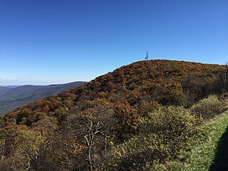
Hogback Mountain is the highest peak in the northern portion of Shenandoah National Park as well as the highest point in Warren County in northern Virginia, United States. A part of the Blue Ridge Mountains, it is located along the border of Warren and Rappahannock counties. It is easily accessible via Skyline Drive and the Appalachian Trail.

Tunnabora Peak is a 13,563-foot-elevation (4,134-meter) mountain summit located on the crest of the Sierra Nevada mountain range in California. It is situated on the common border of Tulare County with Inyo County, as well as the shared boundary of Sequoia National Park and John Muir Wilderness. It is set above the north shore of Tulainyo Lake, 13 miles (21 km) west of the community of Lone Pine, 1.86 miles (2.99 km) north-northeast of Mount Whitney, and 0.9 miles (1.4 km) north-northwest of Mount Carillon. Tunnabora ranks as the 51st-highest peak in California. Topographic relief is significant as it rises approximately 5,200 feet above Whitney Portal in approximately three miles.


