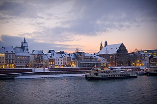
Maastricht is a city and a municipality in the southeastern Netherlands. It is the capital and largest city of the province of Limburg. Maastricht is located on both sides of the Meuse, at the point where the river is joined by the Jeker. Mount Saint Peter (Sint-Pietersberg) is largely situated within the city's municipal borders. Maastricht is adjacent to the border with Belgium and is part of the Meuse-Rhine Euroregion, an international metropolis with a population of about 3.9 million, which includes the nearby German and Belgian cities of Aachen, Liège, and Hasselt.

Antwerp Province, between 1815 and 1830 known as Central Brabant, is the northernmost province both of the Flemish Region, also called Flanders, and of Belgium. It borders on the North Brabant province of the Netherlands to the north and the Belgian provinces of Limburg, Flemish Brabant and East Flanders. Its capital is Antwerp, which includes the Port of Antwerp, the second-largest seaport in Europe. It has an area of 2,876 km2 (1,110 sq mi), and with over 1.92 million inhabitants as of January 2024, is the country's most populous province. The province consists of three arrondissements: Antwerp, Mechelen and Turnhout. The eastern part of the province comprises the main part of the Campine region.

Limburg, also known as Belgian Limburg, is a province in Belgium. It is the easternmost of the five Dutch-speaking provinces that together form the Region of Flanders, which is one of the three main political and cultural sub-divisions of modern-day Belgium. As of January 2024, Limburg had a population of 0.9 million.
Articles related to Belgium include:

As is a municipality located in the Belgian province of Limburg. On January 1, 2006, As had a total population of 7,497. The total area is 22.07 km2 which gives a population density of 340 inhabitants per km2.
Genk is a city and municipality located in the Belgian province of Limburg near Hasselt. The municipality only comprises the town of Genk itself. It is one of the most important industrial towns in Flanders, located on the Albert Canal, between Antwerp and Liège.

Zonhoven is a municipality located in the middle of the Belgian province of Limburg located north of Hasselt and also borders Houthalen-Helechteren, Genk and Heusden-Zolder. It’s an urbanized municipality, in the edge area of Hasselt. The municipality belongs to the On January 1, 2019, Zonhoven had a total population of 21,237. The total area is 39.34 km2 which gives a population density of 506 inhabitants per km2.

Zutendaal is a municipality located in the Belgian province of Limburg. On 1 January 2017 Zutendaal had a total population of 7,269. The total area is 32.07 km2, giving a population density of 227 inhabitants per km2.
Lanaken is a municipality located in the Belgian province of Limburg. On January 1, 2007, the municipality of Lanaken had a total population of 24,724. Its area is 59.00 km2 which gives a population density of 415 inhabitants per km2.

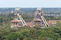
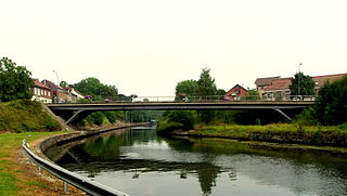
Maasmechelen is a municipality located on the Meuse in the Belgian province of Limburg.

The Campine or Kempen is a natural region situated chiefly in north-eastern Belgium and parts of the south-eastern Netherlands which once consisted mainly of extensive moors, tracts of sandy heath, and wetlands. It encompasses a large northern and eastern portion of Antwerp Province and adjacent parts of Limburg in Belgium, as well as portions of the Dutch province of North Brabant and Dutch Limburg around Weert.

The Cauberg is a hill in Valkenburg aan de Geul, a town in the South Limburg region of the Netherlands. The hill played an important role in the early development of tourism in Valkenburg. Today, several major tourist attractions are situated on or nearby Cauberg. The hill's fame is mainly due to the many cycling races and championships that were held here. The length of the climb is around 1,200 metres (0.7 mi), with a maximum grade of 12%.
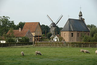
The Bokrijk Provincial Domain is a park and museum complex near Genk, Province of Limburg in Belgium. It is known for its open-air museum which displays a large collection of historical buildings from across Flanders which presents the history of rural life in the region. The domain is 5.5 square kilometres (2.1 sq mi) in area and also hosts an important botanical garden (arboretum), nature reserve, and the largest open-air playground in Flanders.

The European route E314 is a road in Europe and a part of the United Nations International E-road network. Approximately 125 kilometers (78 mi) long, it connects the Belgian university city of Leuven with Aachen, Charlemagne's capital during the early ninth century, and today a bustling commercial centre in Germany's North Rhine-Westphalia.

Z33 is an art institution in Hasselt that connects art, design and architecture with social themes. Z33 presents itself as an art centre and not as a museum. In fact, the house initiates, produces and displays temporary exhibitions, without a permanent collection. Here, the starting point is the intersection between contemporary art and design. The artistic exhibitions that Z33 creates and presents refer to social developments and scientific phenomena.
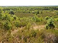
Cartierheide is a natural landscape area in the south of the Netherlands in province North Brabant located close to the Belgian border in the natural region called The Campine . On the other side of the border is Belgium's first national park, Hoge Kempen.

The numbered-node cycle network is a wayfinding system. It spans the Netherlands, Belgium, parts of France and Germany, and parts of Croatia, and is expanding rapidly, as of 2017. Each intersection or node is given a number, and the numbers are signposted, so the cyclist always knows which way to go to get to the next node.
The manhunt for Jürgen Conings began on 18 May 2021, after the discovery that Conings, a Belgian soldier under suspicion of far-right extremism, had taken several weapons from military barracks in Leopoldsburg the previous day and farewell letters were found containing violent threats directed at the Belgian government and virologists. On 20 June 2021, Belgian media reported that a body had been found in the Dilserbos forest, which was later confirmed by the Federal Prosecutor's Office to be the body of Jürgen Conings. One day later, the Federal Prosecutor's Office confirmed that Conings died of suicide by gunshot, which was disputed by his family. A second autopsy was denied and he was cremated a few days later.
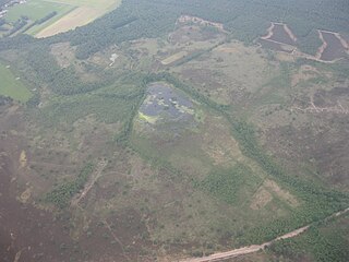
The Cyclo-cross Maasmechelen race, sometimes called Cyclocross Maasmechelen or Wereldbeker Maasmechelen is a cyclo-cross race held in Maasmechelen, in the Province of Limburg in Belgium. The race has been held since 2022 and has been part of the UCI Cyclo-cross World Cup since then. The race is held in Hoge Kempen National Park on the location of the former coal mines of Eisden. The course has some steep down ramps and a longer off-camber section.