
Hinnøya is the fourth largest island in Norway. The 2,204.7-square-kilometre (851.2 sq mi) lies just off the western coast of Northern Norway. The island sits on the border of Nordland and Troms counties. The western part of the island is in the district of Vesterålen, the southwestern part is in the Lofoten district, the southeastern part is in the Ofoten district, and the northeastern part is in Southern Troms.

Stokmarknes Airport, Skagen is an airport in Hadsel Municipality in Nordland county, Norway. It is located on the island of Langøya, about 5 kilometres (3.1 mi) northeast of the town of Stokmarknes and about 20 kilometres (12 mi) southwest of the town of Sortland.

Løding is a village in the municipality of Bodø in Nordland county, Norway. It is located about 17 kilometres (11 mi) east of the town of Bodø, and is connected to the town by the Tverlandet Bridge. The village is mostly referred to as Tverlandet, which also encompasses the areas Hopen, Vatne, Heggmoen, Mjønes, Vågan, Holand, Skålbunes, Elstad, Oddan, Allmenningen, Godøynes (Gaunes), and Naurstad, all of which lies around the village.

Baugevatnet is a lake that lies in Tysfjord Municipality in Nordland county, Norway. The 4.99-square-kilometre (1.93 sq mi) lake is located about 25 kilometres (16 mi) east of the village of Kjøpsvik and just 1.5 kilometres (0.93 mi) northwest of the border with Sweden. The lake Båvrojávrre lies about 3 kilometres (1.9 mi) to the southwest and the lake Langvatnet lies about the same distance to the north.
Børsvatnet (Norwegian) or Bođatjávri (Northern Sami) is a lake in the municipality of Ballangen in Nordland county, Norway. The 11.6-square-kilometre (4.5 sq mi) lake is located about 3.5 kilometres (2.2 mi) southwest of the village of Ballangen.
Gjømmervatnet is a lake that lies in the municipality of Bodø in Nordland county, Norway. The 6.66-square-kilometre (2.57 sq mi) lake lies about 7 kilometres (4.3 mi) southwest of the village of Misvær in the Skjerstad area of Bodø. The lake is regulated for use for the Oldereid Hydroelectric Power Station, northwest of Misvær.
Grovatnet is a lake that lies in the municipality of Sørfold in Nordland county, Norway. The 2.64-square-kilometre (1.02 sq mi) lake is located northeast of the Sagfjorden, about 15 kilometres (9.3 mi) southwest of the village of Mørsvikbotn.
Liland is a village in Sortland Municipality in Nordland county, Norway. The village is located on the island of Hinnøya along the Sortlandssundet strait, about 10 kilometres (6.2 mi) northeast of the town of Sortland, and just north of the Kvalsaukan Bridge.

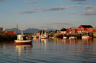
Sigerfjord is a village in Sortland Municipality in Nordland county, Norway. The village is located on the island of Hinnøya by the entrance to the Sigerfjorden. The village of Strand and the Sortland Bridge are located about 6 kilometres (3.7 mi) to the north. Sigerfjord Church is located in this village.
Strand is a village in Sortland Municipality in Nordland county, Norway. The village is located on the island of Hinnøya at the eastern end of the Sortland Bridge which crosses the Sortlandsundet strait and connects to the town of Sortland on Langøya island. It is located about 5 kilometres (3.1 mi) north of the village of Sigerfjord.
Holand is a village in the municipality of Vega in Nordland county, Norway. It is located on the north end of the island of Vega about 3.5 kilometres (2.2 mi) north of the village of Gladstad.
Bø is a village in Sortland Municipality in Nordland county, Norway. The village is located on the island of Langøya along the Sortlandssundet strait, about 6 kilometres (3.7 mi) southwest of the town of Sortland and about 4 kilometres (2.5 mi) northeast of the village of Holand.

Langøya is the third largest island of Norway, with an area of 850.2 square kilometres (328.3 sq mi). The island is a part of the Vesterålen archipelago in Nordland county, Norway. The island includes the municipalities of Bø and Øksnes as well as parts of the municipalities of Sortland and Hadsel.

Gullesfjorden is a fjord that cuts into the island of Hinnøya in Troms county, Norway. It is located mostly within Kvæfjord Municipality, although a small part in the northwestern part of the fjord lies in Sortland Municipality in Nordland county. The inner head of the ford is known as Gullesfjordbotn.
Holmstad is a village in Sortland Municipality in Nordland county, Norway. The village is located along the Eidsfjorden on the island of Langøya, about 12 kilometres (7.5 mi) west of the town of Sortland. Indre Eidsfjord Church is located in this village.

County Road 820 is a 73.1-kilometer (45.4 mi) road in the municipalities of Bø, Øksnes, and Sortland in Nordland County, Norway. It starts in the village of Straumsnes in the municipality of Bø, where it continues south from County Road 901, circles around the west end of the island of Langøya through the Straume Nature Reserve to the village of Straume, and continues east to the Ryggedal Tunnel. It then passes through the municipality of Øksnes along the west shore of Ånnfjord and south shore of Skjellfjord before entering the municipality of Sortland. There it passes along the inner shore of Eidsfjord through Frøskeland, crosses Vikeid, where County Road 956 branches off to Vik, and then runs past the southwest shore of the Vikosen Nature Reserve and along the west side of Sortlandssundet strait, where it terminates at the town of Sortland.
Vik is a village in Sortland Municipality in Nordland county, Norway. The village is located on the island of Langøya, about 13 kilometers (8.1 mi) north of the town of Sortland.

Sortland (help·info) is a town and the administrative centre of Sortland Municipality in Nordland county, Norway. The town is located on the east coast of the island of Langøya, along the Sortlandsundet strait. In 1997, the municipality decided to declare "town status" for the urban area of Sortland. Sortland is the largest town and commercial centre in the whole Vesterålen region and it is becoming known as "the blue town by the strait" since many of the buildings are painted blue.


