Related Research Articles

Chippewa County is a county located in the U.S. state of Wisconsin. It is named for the historic Chippewa people, also known as the Ojibwe, who long controlled this territory. As of the 2010 census, the population was 62,415. Its county seat is Chippewa Falls. The county was founded in 1845 from Crawford County, then in the Wisconsin Territory, and organized in 1853.

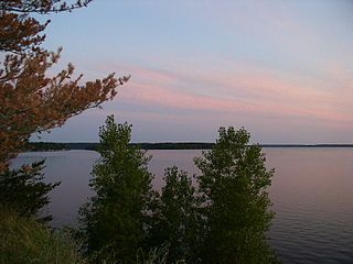
Lake Holcombe is a town in Chippewa County in the U.S. state of Wisconsin. Its population was 1,031 at the 2010 census. The census-designated place of Holcombe is located in the town.

Clam Falls is a town in Polk County, Wisconsin, United States. The population was 547 at the 2000 census. The unincorporated communities of Clam Falls and Lewis are located in the town.

The Jump River is a small rocky river in north-central Wisconsin. In the late 19th century it was used to drive logs down to the Chippewa River. Today it is recreational, rambling through woods and farmlands, used mostly by fishermen and paddlers.
Lake Wissota is a reservoir in Chippewa County, Wisconsin, United States, just east of the city of Chippewa Falls. It covers an area of 6,024 acres (2,438 ha) and has a maximum depth of 72 feet (22 m).

Tainter Lake is a small reservoir in north central Dunn County, Wisconsin, on the Red Cedar River at its confluence with the Hay River. The lake was created by a hydroelectric dam (about 3 miles downstream on the Red Cedar at Cedar Falls. The lake, a popular resort and fishing spot, has a surface area of approximately 2 square miles.

The Red Cedar River in northwestern Wisconsin is a tributary of the Chippewa River. Its name is translation from the Ojibwe Miskwaawaakokaan-ziibi meaning "Abundant with Red Cedar River." According to the Wisconsin Department of Natural Resources, the river flows approximately 100 miles from southwestern Sawyer County to its confluence with the Chippewa southeast of Dunnville in southern Dunn County. It drains portions of eight Wisconsin counties: Barron, Chippewa, Dunn, Polk, Rusk, St. Croix, Sawyer, and Washburn.

The Chippewa River in Wisconsin flows approximately 183 miles (294 km) through west-central and northwestern Wisconsin. It was once navigable for approximately 50 miles (80 km) of its length, from the Mississippi River, by Durand, northeast to Eau Claire. Its catchment defines a portion of the northern boundary of the Driftless Area. The river is easily accessible for bikers and pleasure seekers via the Chippewa River State Trail which follows the river from Eau Claire to Durand.
The Yellow River in north central Wisconsin is a tributary of the Chippewa River. For the most part it is a mud and rock-bottomed river flowing through forest and farmland. It is one of four distinct rivers in the state bearing the name Yellow River.

Old Abe State Trail is a 19.5-mile (31.4 km) paved multi-use rail trail in Chippewa County, Wisconsin, USA.

The Flambeau River is a tributary of the Chippewa River in northern Wisconsin, United States. The Chippewa is in turn a tributary of the upper Mississippi River. The Flambeau drains an area of 1,860 square miles (4,800 km2) and descends from an elevation of approximately 1,570 feet (480 m) to 1,060 feet (320 m) above sea level. The Flambeau is an important recreational destination in the region. It is notable among canoeists in the Midwest for outstanding canoe camping, including excellent scenery, fishing and whitewater. The river and its forks have a variety of possible trip lengths from short day outings, to overnight camping, to voyages of a week or more.
Lake Altoona, is a man-made lake in Eau Claire County, Wisconsin, United States, bordering the city of Altoona, Wisconsin, and to the east of Eau Claire.
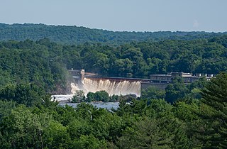
Eau Claire Dam is a dam in Eau Claire County, Wisconsin, United States.

Swamp Creek is a tributary of the Flambeau River in northern Wisconsin, USA. The Flambeau is in turn a tributary of the Chippewa River.
The Turtle-Flambeau Flowage is a 12,942 acres (52.37 km2) lake, in Iron County, Wisconsin. It has a maximum depth of 15 meters and is the seventh largest lake in the state of Wisconsin by surface area. The flowage is home to unique wetland patterns and plant species as well as several species of sport and game fish, including Musky, Panfish, Largemouth Bass, Smallmouth Bass, Northern Pike, Walleye and Sturgeon. The lake's water clarity is low, but can vary in different locations in the lake. Fishing, camping, boating, and hunting are popular activities on the flowage, and Ojibwe people traditionally harvest fish and game on the lake. Environmental concerns on the flowage include mercury contamination, algal blooms, and several types of invasive species.
The Willow Reservoir or Willow Flowage is an artificial lake in Oneida County, Wisconsin formed by a dam on the Tomahawk River. The dam and reservoir level are controlled by the Wisconsin Valley Improvement Company as part of regulating the overall flow of the upper Wisconsin River. When full, Willow Reservoir has a surface area of 6306 acres.

The Jersey City Flowage is an artificial lake on the Tomahawk River, located about one mile above the confluence with the Wisconsin River in Tomahawk, Wisconsin. The dam and the flow are controlled by the Wisconsin Valley Improvement Company. The dam was originally built in 1910 to provide power for a tannery.Jersey City Flowage is a 423 acre lake located in Lincoln County. It has a maximum depth of 20 feet.
Pine Lake is a lake in Rusk and Chippewa Counties, Wisconsin. It has a surface area of 256 acres (104 ha) and is surrounded by a forest. The maximum depth of the lake is 106 feet (32 m). Pine Lake is at an elevation of 1,101 feet (336 m). The bottom of the lake is 50% sand, 30% gravel, 15% rock, and 5% muck. Pine Lake is a seepage lake, which does not have an inlet or outlet and gets its water mostly from precipitation or runoff. Because of this, water levels tend to fluctuate seasonally.
Saint Croix Falls Dam, also known as St. Croix Falls Dam, is a hydroelectric dam in St. Croix Falls, Wisconsin. The only dam on the St. Croix River, it is operated by Xcel Energy. The Nevers Dam, 11 miles up river, was used by loggers before it was badly damaged by flooding in 1954 and demolished by the company that owned it the following year.
References
- ↑ http://dnr.wi.gov/lakes/LakePages/LakeDetail.aspx?wbic=2184900&page=facts
- ↑ http://dnr.wi.gov/lakes/maps/DNR/2184900a.pdf [ bare URL PDF ]
- ↑ http://www.xcelenergy.com/About_Us/Our_Company/Power_Generation/Holcombe_Hydro_Generating_Station
- ↑ Rosholt, Malcolm L. (1982). Lumbermen on the Chippewa. Rosholt House. pp. 195–198. ISBN 0-910417-00-8.