Related Research Articles

The Shire of Moorabool is a local government area in Victoria, Australia, located in the western part of the state. It covers an area of 2,111 square kilometres (815 sq mi) and, in June 2018, had a population of 34,158. It includes the towns of Ballan, Bacchus Marsh, Balliang, Mount Wallace, Myrniong, Blackwood, Greendale, Gordon, Korweinguboora and Mount Egerton, Bungaree, Elaine and Wallace. It was formed in 1994 from the amalgamation of the Shire of Bacchus Marsh, Shire of Ballan and parts of the Shire of Bungaree and City of Werribee.
Cremorne railway station was an inner suburban station in Melbourne, Australia. It was on the Melbourne and Suburban Railway Company’s line from Princes Bridge station to Windsor station, and was located just north of Balmain Street on the Melbourne side of the Yarra River bridge, in a part of the suburb of Richmond which is now known as Cremorne.
The Outer Circle Railway was opened in stages in 1890 and 1891, as a steam-era suburban railway line, in Melbourne, Australia. It traversed much of the modern City of Boroondara, including the suburbs of Kew East, Camberwell, Burwood, Ashburton, and Malvern East. At its longest, it ran from Fairfield station, on what is today the Hurstbridge line, to Oakleigh station, on the current Gippsland line.
Botanic Gardens was an early inner suburban railway station in Melbourne, Australia. It was a small station built to serve both the Melbourne Cricket Ground and Royal Botanic Gardens. The station was located near the narrow humpback footbridge from Yarra Park to Swan Street between Princes Bridge and Richmond Stations.

Western Highway is a major arterial route in western Victoria with a length of approximately 258 kilometres (160 mi) of single carriageway, then 161 kilometres (100 mi) of dual carriageway known as Western Freeway, linking the western suburbs of Melbourne to the border with South Australia at Serviceton. It is the Victorian part of the principal route linking the Australian cities of Melbourne and Adelaide, and is a part of the National Highway network, designated routes A8 and M8. The western end continues into South Australia as Dukes Highway, the next section of the Melbourne–Adelaide National Highway.
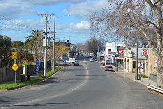
Bacchus Marsh is a town in Victoria, Australia located approximately 50 kilometres (30 mi) north-west of the state capital Melbourne, at a near equidistance to the major cities of Melbourne, Ballarat and Geelong.
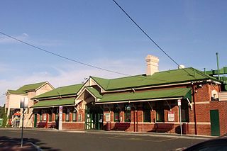
Bacchus Marsh railway station is a regional railway station on the Ararat line, part of the Victorian railway network. It serves the southern suburb of Maddingley, in Bacchus Marsh, Victoria, Australia. Bacchus Marsh station is a ground level premium station, featuring two side platforms. It opened on 10 February 1887, with the current station provided in 2019.

The Walhalla railway line was a 2 ft 6 in narrow gauge railway located in Gippsland, Victoria, Australia. The line ran from Moe to the former gold-mining town and popular tourist destination of Walhalla. Construction began in 1904. The line closed in sections from 1944 to 1954.

Cremorne Gardens was a pleasure garden established in 1853 on the banks of the Yarra River at Richmond in Melbourne, Australia. The gardens were established by James Ellis who had earlier managed and leased similar gardens of the same name on the banks of the River Thames at Chelsea in London. He had been declared bankrupt and emigrated to Australia to take advantage of the business opportunities made possible by the Victorian gold rush and its accompanying population explosion. His first venture in the entertainment world in Melbourne was Astley's Amphitheatre, but his experiences in catering in London inclined him to a profit making business with a wider basis. Because of previous experience he had established contacts in the theatrical world of London. He took advantage of them to create a venue with viable entertainments to divert the population of the rapidly expanding capital of the new Australian state where entertainment was demanded by a predominantly male society.

The Ararat railway line is a railway line in Victoria, Australia. It links the state capital of Melbourne to the cities of Ballarat and Ararat via the Regional Rail Link.
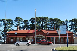
Ballan railway station is a regional railway station on the Ararat line, part of the Victorian railway network. It serves the town of Ballan, in Victoria, Australia. Ballan station is a ground level premium station, featuring two side platforms. It opened on 22 December 1886, with the current station provided in 2021.
The Lerderderg Gorge is in Victoria, Australia and largely within the Lerderderg State Park. The Lerderderg River which emerges from the Great Dividing Range has cut a deep gorge as it winds toward the southern plains. It is suggested that the name Lerderderg is perhaps a corruption of the Wurundjeri word "Larderdark," from 'larh' -stone house and 'dark' -peppermint gum.

Parwan is a closed station located in the town of Parwan, near Bacchus Marsh, on the Ararat railway line in Victoria, Australia. The station platform was on the southern side of the line. Today, Parwan is a crossing loop, permitting trains up to 969 metres long to cross.

Bullengarook is a locality in Victoria, Australia. The locality is centred on Bacchus Marsh Road, 14 kilometres (9 mi) west of Gisborne and 19 km north of Bacchus Marsh. Bullengarook is in the Shire of Macedon Ranges local government area. At the 2011 Census, Bullengarook and the surrounding area had a population of 603. Mount Bullengarook, the Lerderderg State Park and the headwaters of Coimadai Creek are found to the south of the township.

The Ballarat line is a regional passenger rail service operated by V/Line in Victoria, Australia. It serves 13 stations towards its terminus in Ballarat's western suburb of Wendouree via Melton and Bacchus Marsh. Services are operated primarily using V/Line VLocity diesel multiple unit sets in either 3- or 6-car configurations.

The Shire of Bacchus Marsh was a local government area about 50 kilometres (31 mi) west of Melbourne, the state capital of Victoria, Australia. The shire covered an area of 565 square kilometres (218.1 sq mi), and existed from 1862 until 1994.

Alfred Thomas Montgomery Madden Ozanne was an Australian politician. He was an Australian Labor Party member of the Australian House of Representatives from 1910 to 1913 and 1914 to 1917, both times for the seat of Corio.
Tylden railway station, a former station on the Daylesford railway line in Victoria, Australia, was located about 2.4 km to the east of Tylden township, near Central Road. The station opened at the same time as the Carlsruhe to Trentham section of the line on 16 February 1880, and closing on or before 3 July 1978 when the line was closed.
Maddingley Mine is a mine near Bacchus Marsh Railway Station, Victoria, Australia, that contains a concentration of a particular brown coal (lignite) formation called Leonardite. A relatively high altitude formation, Maddingley brown coal is distinguished as having 60% moisture content and a rich fulvic acid and humic acid content. A declared strategic State mining reserve, the estimated 400 million tonne deposit at Maddingley is the largest of three known deposits of high value Leonardite in the world, the others occurring in Mexico and Germany.

The Cremorne Railway Bridge crosses the Yarra River three kilometres south-east of Melbourne connecting Richmond and South Yarra stations on the Frankston, Pakenham, Cranbourne, and Sandringham railway lines.
References
- ↑ "FLAG STATION AT HOLDEN". The Age . No. 10948. Victoria, Australia. 27 March 1890. p. 9. Retrieved 22 January 2025– via National Library of Australia.
- ↑ "BACCHUS MARSH TO HOLDEN RAILWAY VIA COIMADAI". The Bacchus Marsh Express . No. 1, 307. Victoria, Australia. 18 July 1891. p. 7. Retrieved 22 January 2025– via National Library of Australia.
- ↑ "HOLDEN TO BACCHUS MARSH". The Age . No. 10, 781. Victoria, Australia. 12 September 1889. p. 6. Retrieved 22 January 2025– via National Library of Australia.
- 1 2 Andrew Waugh. "Footscray - Sunbury SRS Tour Notes" (PDF). Victorian Station Histories. Retrieved 27 April 2008.