San Jose, officially the City of San José, is the largest city in Northern California by both population and area. With a 2020 population of 1,013,240, it is the most populous city in both the Bay Area and the San Jose–San Francisco–Oakland Combined Statistical Area, which has a 2015 population of 7.7 million and 9.7 million people respectively, the third-most populous city in California after Los Angeles and San Diego, and the 12th-most populous in the United States. Located in the center of the Santa Clara Valley on the southern shore of San Francisco Bay, San Jose covers an area of 179.97 sq mi (466.1 km2). San Jose is the county seat of Santa Clara County and the main component of the San Jose–Sunnyvale–Santa Clara Metropolitan Statistical Area, with an estimated population of around two million residents in 2018.
San Benito County, officially the County of San Benito, is a county located in the Coast Range Mountains of the U.S. state of California. As of the 2020 census, the population was 64,209. The county seat is Hollister.

Hollister is a city in and the county seat of San Benito County, located in the Central Coast region of California, United States. With a 2020 United States census population of 41,678, Hollister is one of the largest cities in the Monterey Bay Area and a member of the Association of Monterey Bay Area Governments. The city is an agricultural town known primarily for its local Blenheim apricots, olive oil, vineyards, pomegranates, and chocolate.

Dublin is a city in Laurens County, Georgia, United States. As of the 2020 census, the city had a population of 16,074. It is the county seat of Laurens County.

The Santa Clara Valley is a geologic trough in Northern California that extends 90 miles (140 km) south–southeast from San Francisco to Hollister. The longitudinal valley is bordered on the west by the Santa Cruz Mountains and on the east by the Diablo Range; the two coastal ranges meet south of Hollister. The San Francisco Bay borders the valley to the north, and fills much of the northern third of the valley. The valley floor is an alluvial plain that formed in the graben between the San Andreas Fault to the west and the Hayward and Calaveras faults to the east. Within the valley and surrounding the bay on three sides are the urban communities of San Mateo County, Santa Clara County, and Alameda County, while the narrow southern reaches of the valley extend into rural San Benito County to Hollister. In practical terms, the central portion of the Santa Clara Valley is often considered by itself, contained entirely within Santa Clara County.
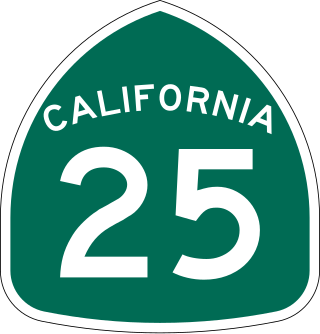
State Route 25 is a state highway in the U.S. state of California between State Route 198 in Monterey County and U.S. Route 101 in Santa Clara south of Gilroy. For most of its length, SR 25 runs through the center of San Benito County.

State Route 156 is a west to east state highway in the U.S. state of California, running from State Route 1 in Castroville to State Route 152 near Hollister. It serves as part of the primary route from the Monterey Peninsula to either the San Francisco Bay Area or the California Central Valley.

The Pajaro River is a U.S. river in the Central Coast region of California, forming part of the border between San Benito and Santa Clara Counties, the entire border between San Benito and Santa Cruz County, and the entire border between Santa Cruz and Monterey County. Flowing roughly east to west, the river empties into Monterey Bay, west of Watsonville, California.
The Calaveras Fault is a major branch of the San Andreas Fault System that is located in northern California in the San Francisco Bay Area. Activity on the different segments of the fault includes moderate and large earthquakes as well as aseismic creep. The last large event was the magnitude 6.2 1984 Morgan Hill event. The most recent moderate earthquakes were the magnitude 5.1 event on 25 October 2022, and the magnitude 5.6 2007 Alum Rock event.

Hollister High School (HHS) is a school in Hollister, California, United States. It serves as the primary high school for Hollister city residents and most county residents and is within the San Benito High School District. The school's enrollment is approximately 3,400 students, served by 250 faculty and staff.

The Sacramento City Library, also known as Central Branch, is part of the Sacramento Public Library system, and faces I Street in Sacramento, California near Sacramento City Hall.

The Carnegie Art Museum is a public art museum owned by the City of Oxnard, California in the building originally occupied by the Oxnard Public Library. The Neo-Classical building, located adjacent to Oxnard's Plaza Park, opened in 1907 as the Oxnard Public Library and was converted into an art museum in 1986. In July 1971, it became the first building in Ventura County and the first Carnegie library in California to be listed on the National Register of Historic Places.

The Woodland Public Library is the oldest, and one of the last functioning Carnegie-funded libraries in California. It is on the National Register of Historic Places and is a contributing property of the Downtown Woodland Historic District.

The Greenville Carnegie Library is a historic library on the edge of downtown Greenville, Ohio, United States. A Carnegie library built for the community in the early 20th century, the library and an adjacent school building have been designated a historic site because of their landmark architecture.

The Everett Carnegie Library is a Carnegie library building located in Everett, Washington, USA listed on the National Register of Historic Places and part of the Snohomish County Government campus. The building occupies the southeast corner of the intersection of Oakes Avenue and Wall Street in the city's central business district.
The 1979 Coyote Lake earthquake occurred at on August 6 with a moment magnitude of 5.7 and a maximum Mercalli Intensity of VII. The shock occurred on the Calaveras Fault near Coyote Lake in Santa Clara County, California and resulted in a number of injuries, including some that required hospitalization. Most of the $500,000 in damage that was caused was non-structural, but several businesses were closed for repairs. Data from numerous strong motion instruments was used to determine the type, depth, and extent of slip. A non-destructive aftershock sequence that lasted throughout the remainder of the month was of interest to seismologists, especially with regard to fault creep, and following the event local governments evaluated their response to the incident.
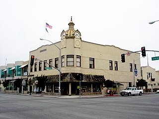
The Downtown Hollister Historic District, in Hollister, California, is a historic district which was listed on the National Register of Historic Places in 1992.
The Superior Court of California, County of Calaveras, also known as the Calaveras County Superior Court, is the branch of the California superior court with jurisdiction over Calaveras County.
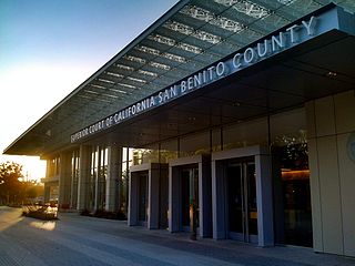
The Superior Court of California, County of San Benito, also known as the San Benito County Superior Court or San Benito Superior Court, is the branch of the California superior court with jurisdiction over San Benito County.

The Superior Court of California, County of Monterey, also known as the Monterey County Superior Court or Monterey Superior Court, is the branch of the California superior court with jurisdiction over Monterey County.


