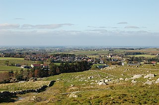
Kleppe is the administrative centre of Klepp municipality in Rogaland county, Norway. The village is located about halfway between the lakes Orrevatnet and Frøylandsvatnet. The village of Bore lies about 3 kilometres (1.9 mi) northwest of Kleppe and the village of Klepp stasjon lies about 3 kilometres (1.9 mi) to the east. The town of Bryne lies about 5 kilometres (3.1 mi) to the south and the city of Sandnes is located about 12 kilometres (7.5 mi) to the northeast. Klepp Church is located in Kleppe.

Mossige is a village in Time municipality in Rogaland county, Norway. The village is a small farming village composed of about one dozen farms and homes. It is located about 5 kilometres (3.1 mi) southeast of the town of Bryne, the same distance northeast of the village of Nærbø, and about 3.5 kilometres (2.2 mi) west of the village of Undheim.

Tau is a village in Strand municipality in Rogaland county, Norway. The village is located on the shore of the Horgefjorden, a branch of the main Boknafjorden. The 2.11-square-kilometre (520-acre) village has a population (2015) of 3,158 which gives the village a population density of 1,497 inhabitants per square kilometre (3,880/sq mi). Strand Church is located in the village.
Undheim is a village in Time municipality in Rogaland county, Norway. The village is located in Jæren, about 14 kilometres (8.7 mi) south of the village of Ålgård, about 12 kilometres (7.5 mi) southeast of the town of Bryne, and about 7 kilometres (4.3 mi) east of the village of Nærbø. The village of Mossige lies just to the northwest of Undheim.

Idse is an island in Strand municipality in Rogaland county, Norway. The 4.9-square-kilometre (1.9 sq mi) island lies between the Idsefjorden and Høgsfjorden, about 6.5 kilometres (4.0 mi) west of the town of Jørpeland. The island of Idsal lies immediately to the south and the island of Heng lies a short distance to the north of Idse. There is a bridge connecting Idse to neighboring Idsal, which in turn is connected to the mainland.
Grøsfjellvatnet is a lake in the municipalities of Eigersund, Lund, and Sokndal in Rogaland county, Norway. The 3.09-square-kilometre (1.19 sq mi) lake list just north of the lake Eiavatnet, about 4 kilometres (2.5 mi) west of the village of Heskestad in Lund municipality.

Tysdalsvatnet or Tyssdalsvatnet is a lake in the municipalities of Hjelmeland and Strand in Rogaland county, Norway. The 3.74-square-kilometre (1.44 sq mi) lake lies about 5 kilometres (3.1 mi) south of the village of Årdal and about 8 kilometres (5.0 mi) east of the village of Tau. The Norwegian National Road 13 (Rv13) runs along the northern side of the lake. The Svo Tunnel was completed in 2013 and it routes much of Rv13 through a mountain rather than along the narrow shoreline of the lake.
Vostervatnet is a lake in the municipality of Strand in Rogaland county, Norway. The 2.62-square-kilometre (1.01 sq mi) lake lies in the northwestern part of Strand, just south of the Fognafjorden. The village of Tau lies about 3.5 kilometres (2.2 mi) southwest of the lake. The main outflow of the lake is the river Fiskåna, which flows north from the northeastern corner of the lake, down the hill to the village of Fiskå on the shore of the fjord.
Ørsdalsvatnet or Ørdalsvatnet is a lake in the municipality of Bjerkreim in Rogaland county, Norway. The 12.22-square-kilometre (4.72 sq mi) lake lies about 2 kilometres (1.2 mi) northeast of the village of Bjerkreim. The lake is rather narrow, but it is 15 kilometres (9.3 mi) long.
Øvre Tysdalsvatnet is a lake in the municipality of Hjelmeland in Rogaland county, Norway. The 9-square-kilometre (3.5 sq mi) lake lies on the east side of the village of Årdal. The 12-kilometre (7.5 mi) long lake is only about 800 metres (0.5 mi) wide and it has a fairly steep shoreline, which results in very little habitation around the lake.
Austrumdalsvatnet is a lake in the municipality of Bjerkreim in Rogaland county, Norway. The 2.81-square-kilometre (1.08 sq mi) lake lies about 2.5 kilometres (1.6 mi) southeast of the lakes Hofreistæ and Byrkjelandsvatnet. The village of Øvrebygd lies about 3 kilometres (1.9 mi) west of the lake.
Byrkjelandsvatnet or Storavatnet is a lake in the municipality of Bjerkreim in Rogaland county, Norway. The 5.17-square-kilometre (2.00 sq mi) lake lies about 2 kilometres (1.2 mi) north of the village of Øvrebygd. The lake flows out through the short river Malmeisåna which flows into the lake Hofreistæ.

Holmavatnet is a lake the Setesdalsheiene mountains of Southern Norway. It is located on the border of the municipalities of Suldal, Vinje, and a small part in Bykle. The southeastern corner of the lake is in Bykle, and it is the northernmost part of all of Aust-Agder county. The lake Skyvatn is located about 5 kilometres (3.1 mi) to the south of the lake.
Fiskå is a village in Strand municipality in Rogaland county, Norway. The village is located along the Årdalsfjorden, about 10 kilometres (6.2 mi) northeast of the village of Tau. The small farming village of Holta is located a short distance south of Fiskå. The lake Vostervatnet lies just up the hill to the south of the village. The lake drains out through the river Fiskåna which flows through the village of Fiskå on its way to the fjord.

Vikebygd is a village in Vindafjord municipality in Hordaland county, Norway. The village is located along the Ålfjorden, about 9 kilometres (5.6 mi) straight west of the village of Ølensvåg. The village was the administrative centre of the former municipality of Vikebygd which existed from 1902 until 1964. Vikebygd is the site of Vikebygd Church. The village is a mostly agricultural area, although many residents commute to the nearby city of Haugesund, about 40 kilometres (25 mi) to the southwest.
Flassavatnet is a lake in Rogaland county, Norway. The lake lies on the border of the municipalities of Gjesdal and Sandnes. The 0.9243-square-kilometre (0.3569 sq mi) lake sits about 1 kilometre (0.62 mi) north of the large village of Ålgård, not far north of the lakes Edlandsvatnet and Limavatnet. The lake is a reservoir with a small dam on the southern edge of the lake. The water level is kept at about 177 metres (581 ft) above sea level. The reservoir holds about 900,000 cubic metres.

The 1961 Holtaheia Vickers Viking crash was a controlled flight into terrain incident on 9 August 1961 at Holta in Strand, Norway. The Eagle Airways Vickers 610 Viking 3B Lord Rodney was en route from London to Stavanger Airport, Sola on an AIR Tours charter flight taking a school group for a camping holiday. The aircraft was making an instrument landing when it crashed 54 km (34 mi) north east of Stavanger. The accident killed all 39 people on board.

Heng is a small island in the Strand municipality of Rogaland, Norway. The 0.6-square-kilometre (150-acre) island lies in the Idsefjorden, about 3 kilometres (1.9 mi) southwest of the village of Tau on the mainland. Heng lies roughly halfway between the islands of Hidle and Idse.
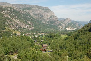
Oltedal is a village in Gjesdal municipality in Rogaland county, Norway. The village is located in a narrow river valley about 11 kilometres (6.8 mi) northeast of the municipal centre of Ålgård and about 9 kilometres (5.6 mi) west of the village of Dirdal, just west of the Høgsfjorden. The lake Oltedalsvatnet lies on the southwestern edge of the village. Oltedal Church is located in the village. The village has some small industries such as yarn making, chemicals, and sand/gravel pits.