
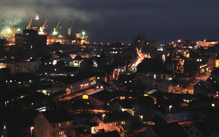
Sandnes is a city and municipality in Rogaland, Norway. It lies immediately south of Stavanger, the 4th largest city in Norway, and together the Stavanger/Sandnes area is the third-largest urban area in Norway. The urban city of Sandnes lies in the extreme western part of the vast municipality and it makes up about 5% of the total land area of the municipality.

Kleppe is the administrative centre of Klepp municipality in Rogaland county, Norway. The village is located about halfway between the lakes Orrevatnet and Frøylandsvatnet. The village of Bore lies about 3 kilometres (1.9 mi) northwest of Kleppe and the village of Klepp stasjon lies about 3 kilometres (1.9 mi) to the east. The town of Bryne lies about 5 kilometres (3.1 mi) to the south and the city of Sandnes is located about 12 kilometres (7.5 mi) to the northeast. Klepp Church is located in Kleppe.

Bryne is a town in Time municipality in Rogaland county, Norway. The town is the administrative centre of the municipality of Time and it is also one of the 50 largest towns/cities in Norway. Bryne's location in the region of Stavanger/Sandnes and its road and rail links have made Bryne a popular area for commuters. The town is expanding rapidly and there have been reports of problems with schooling capacity. Bryne Church is located in the centre of the town and Time Church is located 1 kilometre (0.62 mi) east of the town.

Strand is a municipality in Rogaland county, Norway. It is located in the traditional district of Ryfylke. The administrative centre of the municipality is the town of Jørpeland. The municipality lies across the fjord from the city of Stavanger. The Ryfast tunnel system connects Stavanger and Strand by a very long undersea tunnel.
Holta is a small farming village in the municipality of Strand in Rogaland county, Norway. The farm is situated on the northern hills overlooking the lake Bjørheimsvatn. It is approximately 9 kilometres (5.6 mi) northeast of the village of Tau and about 4 kilometres (2.5 mi) south of the village of Fiskå. The city of Stavanger lies about 25 kilometres (16 mi) southwest of Holta.
Moi is the administrative centre of Lund municipality in Rogaland county, Norway. The village is located at the northern end of the lake Lundevatnet, one of the deepest lakes in Norway. The European route E39 highway passes through Moi. The Sørlandet Line also runs through Moi, stopping at Moi Station.
Jørpeland is the administrative centre of Strand municipality in Rogaland county, Norway. The town is located on the western coast of the mainland, along the shore of the Idsefjorden, about 20 kilometres (12 mi) northeast of the city of Stavanger. It sits along the Norwegian National Road 13 a short distance southeast of the village of Tau where the Ryfast tunnel has its eastern entrance. The name "Jørpeland" is composed of the slightly changed Old Norse word "jarpr", which translates to brown, and the word land ("brownland"). The reason for this name is that historically, the river Jørpelandsånå used to turn brown during times of flood.

or Åkrahamn is a small town in Karmøy municipality in Rogaland county, Norway. The town is located on the west side of the island of Karmøy in the traditional district of Haugaland. The town sits about 5 kilometres (3.1 mi) west of the town of Kopervik, about 12 kilometres (7.5 mi) north of the town of Skudeneshavn, and about 25 kilometres (16 mi) southwest of the town of Haugesund. The village of Veavågen lies immediately to the northeast of Åkrehamn.
Stenebyen or Tjelta is a village in Sola municipality in Rogaland county, Norway. The village is located in the south part of the municipality, about 2 kilometres (1.2 mi) southeast of the village of Hålandsmarka. The 0.39-square-kilometre (96-acre) village has a population (2019) of 1,004 and a population density of 2,574 inhabitants per square kilometre (6,670/sq mi).
The larger Kvernaland area is an amalgamation of villages in Rogaland county, Norway. The village is located along the north end of the lake Frøylandsvatnet. The village is located in both the municipalities of Klepp and Time. The eastern part of the village is also known as Orstad and the western part of the village is known as Frøyland or simply as Kvernaland. The village of Klepp stasjon lies just southwest of the village on the west side of the lake and the small village of Foss Eikjeland lies just north of the village, along the river Figgjo.

Ogna is a village in Hå municipality in Rogaland county, Norway. The village is located immediately north of the village of Sirevåg on the shores of the Ognaelva river. The village was the administrative centre of the historic municipality of Ogna. The village is the site of Ogna Station, a railway station along the Sørlandet Line.
Pollestad is a village in Klepp municipality in Rogaland county, Norway. The village is located south of the lake Orrevatnet and about 5 kilometres (3.1 mi) southwest of the town of Bryne. Orre Church is located in Pollestad. It was built in 1950 to replace the nearly 800-year-old Old Orre Church located 3 kilometres (1.9 mi) to the northwest in the village of Orre.
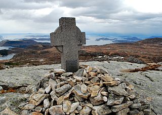
Hålandsmarka is a village in Sola municipality in Rogaland county, Norway. The village is located in the southwestern part of the municipality, about 1 kilometre (0.62 mi) west of the village of Stenebyen. Hålandsmarka is known for a great seaside view of most of the Rogaland coastline, on good days you will be able to see areas as far as 70 kilometres (43 mi) away.

Tysdalsvatnet or Tyssdalsvatnet is a lake in the municipalities of Hjelmeland and Strand in Rogaland county, Norway. The 3.74-square-kilometre (1.44 sq mi) lake lies about 5 kilometres (3.1 mi) south of the village of Årdal and about 8 kilometres (5.0 mi) east of the village of Tau. The Norwegian National Road 13 (Rv13) runs along the northern side of the lake. The Svo Tunnel was completed in 2013 and it routes much of Rv13 through a mountain rather than along the narrow shoreline of the lake.
Vostervatnet is a lake in the municipality of Strand in Rogaland county, Norway. The 2.62-square-kilometre (1.01 sq mi) lake lies in the northwestern part of Strand, just south of the Fognafjorden. The village of Tau lies about 3.5 kilometres (2.2 mi) southwest of the lake. The main outflow of the lake is the river Fiskåna, which flows north from the northeastern corner of the lake, down the hill to the village of Fiskå on the shore of the fjord.
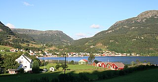
Fiskå is a village in Strand municipality in Rogaland county, Norway. The village is located along the Årdalsfjorden, about 10 kilometres (6.2 mi) northeast of the village of Tau. The small farming village of Holta is located a short distance south of Fiskå. The lake Vostervatnet lies just up the hill to the south of the village. The lake drains out through the river Fiskåna which flows through the village of Fiskå on its way to the fjord.
Sandeid is a village in Vindafjord municipality in Rogaland county, Norway. The village is located at the head of the Sandeidfjorden, about 7 kilometres (4.3 mi) northwest of the village of Vikedal and about 11 kilometres (6.8 mi) south of the village of Ølensjøen. The 0.63-square-kilometre (160-acre) village has a population (2019) of 664 and a population density of 1,054 inhabitants per square kilometre (2,730/sq mi).

Gilja is a village in Gjesdal municipality in Rogaland county, Norway. The village is located about 5 kilometres (3.1 mi) southeast of the village of Dirdal in the Dirdalen valley. The Frafjord Tunnel connects Gilja with the village of Frafjord, located in the next valley on the other side of the mountains.
Sauda is a town in Sauda municipality in Rogaland county, Norway. The town, which is also the administrative centre of the municipality, is located in a river valley at the northern end of the Saudafjorden. The small suburb of Saudasjøen lies about 3 kilometres (1.9 mi) west of the town centre. A large part of the industrial harbour area of Sauda is built on reclaimed land that was once underwater in the fjord.

Heng is a small island in the Strand municipality of Rogaland, Norway. The 0.6-square-kilometre (150-acre) island lies in the Idsefjorden, about 3 kilometres (1.9 mi) southwest of the village of Tau on the mainland. Heng lies roughly halfway between the islands of Hidle and Idse.


