Related Research Articles

Cordite is a family of smokeless propellants developed and produced in the United Kingdom since 1889 to replace gunpowder as a military propellant. Like gunpowder, cordite is classified as a low explosive because of its slow burning rates and consequently low brisance. These produce a subsonic deflagration wave rather than the supersonic detonation wave produced by brisants, or high explosives. The hot gases produced by burning gunpowder or cordite generate sufficient pressure to propel a bullet or shell to its target, but not so quickly as to routinely destroy the barrel of the gun.

The Studland and Godlingston Heaths NNR is located on the Isle of Purbeck in the English county of Dorset. It borders Studland Bay on the south side of Poole Harbour, between the settlements of Swanage and Sandbanks. Extending to 631ha, it is owned and managed by the National Trust following the Bankes bequest of the Kingston Lacy estate. Studland & Godlingston Heath is designated as one of only 35 "spotlight reserves" in England by Natural England in the list of national nature reserves in England and is listed as a Site of Special Scientific Interest (SSSI).

Poole Harbour is a large natural harbour in Dorset, southern England, with the town of Poole on its shores. The harbour is a drowned valley (ria) formed at the end of the last ice age and is the estuary of several rivers, the largest being the Frome. The harbour has a long history of human settlement stretching to pre-Roman times. The harbour is extremely shallow, with one main dredged channel through the harbour, from the mouth to Holes Bay.

Lytchett Minster is a village in Dorset, England. It lies around 4 miles (6.4 km) north-west of Poole town centre. The village forms part of the civil parish of Lytchett Minster and Upton, Upton now being a suburb of Poole.

The Isle of Purbeck is a peninsula in Dorset, England. It is bordered by water on three sides: the English Channel to the south and east, where steep cliffs fall to the sea; and by the marshy lands of the River Frome and Poole Harbour to the north. Its western boundary is less well defined, with some medieval sources placing it at Flower's Barrow above Worbarrow Bay. According to writer and broadcaster Ralph Wightman, Purbeck "is only an island if you accept the barren heaths between Arish Mell and Wareham as cutting off this corner of Dorset as effectively as the sea." The most southerly point is St Alban's Head.
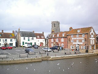
Wareham is a historic market town and, under the name Wareham Town, a civil parish, in the English county of Dorset. The town is situated on the River Frome eight miles (13 km) southwest of Poole.

Purbeck was a local government district in Dorset, England. The district was named after the Isle of Purbeck, a peninsula that forms a large proportion of the district's area. However, it extended significantly further north and west than the traditional boundary of the Isle of Purbeck which is the River Frome. The district council was based in the town of Wareham, which is itself north of the Frome.

Lytchett Matravers is a village and civil parish in Dorset, England. The 2011 census recorded the parish as having 1,439 households and a population of 3,424.

Upton is a town in south-east Dorset, England. Upton is to the east of Holton Heath and north of the Poole suburb of Hamworthy. It is the second largest town in the Purbeck Hills.

Arne is a village and civil parish in Dorset, England, situated 4 miles (6.4 km) east of Wareham. The local travel links are located at Wareham railway station. Bournemouth International Airport is 11 miles (18 km) away. The main road through the village is Arne Road connecting Arne to Wareham. The village is situated on the Arne Peninsula, which protrudes into Poole Harbour opposite the town of Poole.
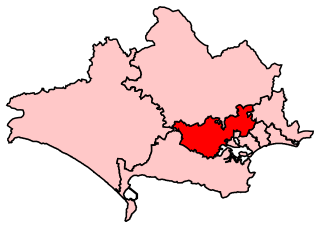
Mid Dorset and North Poole is a constituency represented in the House of Commons of the UK Parliament since 2015 by Michael Tomlinson, a Conservative.
An Explosive ROF was a UK Government-owned Royal Ordnance Factory (ROF), which specialised in manufacturing explosives during and after World War II. Note: In World War I, the name used in the UK for Government-owned explosives factories was National Explosives Factory; and the Cordite factory at Gretna was known as HM Factory, Gretna.

The South East Dorset conurbation is a multi-centred conurbation on the south coast of Dorset in England. The area is rapidly becoming an amalgamation with the area of South West Hampshire immediately on the fringe of the newly formed New Forest National Park. The main population centres are Bournemouth, Christchurch and Poole, which together form the single unitary authority of Bournemouth, Christchurch and Poole; however, the urbanised area spreads as far east as Barton on Sea in Hampshire. There are a number of satellite towns peripheral to these main urban centres. In clockwise rotation these include: Wareham, Upton, Wimborne, Ferndown, Verwood and Ringwood (Hampshire). The urban area is generally surrounded by a green belt.

Holton Heath railway station serves the area of Holton Heath in Wareham St Martin, Dorset, England. It is 118 miles 61 chains (191.1 km) down the line from London Waterloo.

The Royal Naval Cordite Factory, Holton Heath (RNCF) was set up at Holton Heath, Dorset, England, in World War I to manufacture cordite for the Royal Navy. It was reactivated in World War II to manufacture gun propellants for the Admiralty and its output was supplemented by the Royal Navy Propellant Factory, Caerwent. After the end of World War II, the explosive manufacturing areas of the site were closed down and some areas of the site reopened as an Admiralty Research Establishment. A major part of the explosives site became a nature reserve in 1981. Other parts of the site were converted into an industrial estate; and some may be used for housing.

Wareham St Martin is a civil parish in the English county of Dorset. The parish spreads across a large, and mostly rural area to the north of the town of Wareham including much of Wareham Forest. However the town of Wareham lies within its own civil parish, and the only significant settlement within Wareham St. Martin parish is the village of Sandford on the A351 road between Wareham and Poole. The parish also includes the Holton Heath trading estate.

The Dorset Heaths form an important area of heathland within the Poole Basin in southern England. Much of the area is protected.

Decoy Heath is an area of open heathland and bog forming part of Wareham Forest west of the Poole-Bournemouth conurbation in south Dorset, England. It is part of the Dorset Heaths.
References
- ↑ Natural England website
- ↑ "Holton Lee History". www.holtonlee.org. Livability. Retrieved 2020-06-02.
- ↑ Bowditch
- ↑ "How Arne Saved Holton Heath". Dorset Life. March 2009.
Coordinates: 50°43′01″N2°04′26″W / 50.717°N 2.074°W
| This Dorset location article is a stub. You can help Wikipedia by expanding it. |