Related Research Articles

The Snake River is a major river of the greater Pacific Northwest region in the United States. At 1,078 miles (1,735 km) long, it is the largest tributary of the Columbia River, in turn the largest North American river that empties into the Pacific Ocean. The Snake River rises in western Wyoming, then flows through the Snake River Plain of southern Idaho, the rugged Hells Canyon on the Oregon–Idaho border and the rolling Palouse Hills of Washington, emptying into the Columbia River at the Tri-Cities, Washington.

The Snoqualmie River is a 45-mile (72 km) long river in King County and Snohomish County in the U.S. state of Washington. The river's three main tributaries are the North, Middle, and South Forks, which drain the west side of the Cascade Mountains near the town of North Bend and join near the town of Snoqualmie just above the Snoqualmie Falls. After the falls the river flows north through rich farmland and the towns of Fall City, Carnation, and Duvall before meeting the Skykomish River to form the Snohomish River near Monroe. The Snohomish River empties into Puget Sound at Everett. Other tributaries of the Snoqualmie River include the Taylor River and the Pratt River, both of which enter the Middle Fork, the Tolt River, which joins at Carnation, and the Raging River at Fall City.

The Walla Walla River is a tributary of the Columbia River, joining the Columbia just above Wallula Gap in southeastern Washington in the United States. The river flows through Umatilla County, Oregon, and Walla Walla County, Washington. Its drainage basin is 1,758 square miles (4,550 km2) in area.

The Blue Mountains are a mountain range in the northwestern United States, located largely in northeastern Oregon and stretching into extreme southeastern Washington. The range has an area of about 15,000 square miles (38,850 km2), stretching east and southeast of Pendleton, Oregon, to the Snake River along the Oregon–Idaho border.

The Palouse River is a tributary of the Snake River in Washington and Idaho, in the northwest United States. It flows for 167 miles (269 km) southwestwards, primarily through the Palouse region of southeastern Washington. It is part of the Columbia River Basin, as the Snake River is a tributary of the Columbia River.

The Salmon River is a 33.5-mile (53.9 km) river in the Cascade Range in the U.S. state of Oregon that drains part of southwestern Mount Hood. The entire length of the river is a protected National Wild and Scenic River. Several portions are in protected wilderness. It is affluent to the Sandy River, a tributary of the Columbia River.
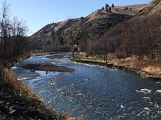
The Touchet River is a 55-mile (89 km) tributary of the Walla Walla River in southeastern Washington in the United States. The Touchet River drains an area of about 740 square miles (1,900 km2) in Columbia County and Walla Walla County.

The Touchet Formation or Touchet beds consist of large quantities of gravel and fine sediment which overlay almost a thousand meters of volcanic basalt of the Columbia River Basalt Group in south-central Washington and north-central Oregon. The beds consist of between 6 and 40 distinct rhythmites – horizontal layers of sediment, each clearly demarcated from the layer below. These Touchet beds are often covered by windblown loess soils which were deposited later; the number of layers varies with location. The beds vary in depth from 330 ft (100 m) at lower elevations where a number of layers can be found to a few extremely thin layers at the maximum elevation where they are observed.
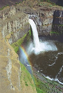
Palouse Falls is a waterfall on the Palouse River, about 4 mi (6 km) upstream of the confluence with the Snake River in southeast Washington, United States. The falls are 200 ft (61 m) in height. The falls consist of an upper fall with a drop around 20 ft (6.1 m), which lies 1,000 ft (305 m) north-northwest of the main drop, and a lower fall, with a drop of 200 ft (61 m). It is in the 94-acre (38 ha) Palouse Falls State Park.

The North Fork John Day Wilderness is a wilderness area within the Umatilla and Wallowa–Whitman National Forests in the Blue Mountains of northeastern Oregon.

The Central Oregon Coast Range is the middle section of the Oregon Coast Range, in the Pacific Coast Ranges physiographic region, and located in the west-central portion of the state of Oregon, United States roughly between the Salmon River and the Umpqua River and the Willamette Valley and the Pacific Ocean. This approximately 90-mile (140 km) long mountain range contains mountains as high as 4,097 feet for Marys Peak. Portions of the range are inside the Siuslaw National Forest and three wilderness areas exist as well: Drift Creek Wilderness, Cummins Creek Wilderness and Rock Creek Wilderness.

The Wenaha–Tucannon Wilderness is a federally designated wilderness area in the Blue Mountains of northeastern Oregon, and southeastern Washington, United States. It was created by the Endangered American Wilderness Act of 1978 and encompasses 177,423 acres (71,801 ha) in the Umatilla National Forest — 66,375 acres (26,861 ha) in Oregon and 111,048 acres (44,940 ha) in Washington.

Trout Creek Hill is a small Pleistocene basaltic shield volcano in Washington, United States. Located in Skamania County, Trout Creek Hill rises to an elevation of 2,946 feet (898 m). It is part of the Cascade Volcanic Arc, located in the Marble Mountain-Trout Creek Hill volcanic field.

Salt Creek Falls is a cascade and plunge waterfall on Salt Creek, a tributary of the Middle Fork Willamette River, that plunges into a gaping canyon near Willamette Pass in the Willamette National Forest, near Oakridge, Oregon. The waterfall is notable for its main drop of 286 feet (87 m) which makes it the third highest plunge waterfall in Oregon after Multnomah Falls and Watson Falls the second highest, which was re-measured in 2009 and found to be 293 feet rather than an earlier measurement of 272 feet passing Salt Creek Falls. The pool at the bottom of the waterfall is 20 metres (66 ft) deep.

The South Fork Clackamas River is a tributary, roughly 8 miles (13 km) long, of the Clackamas River in the U.S. state of Oregon. Beginning near South Fork Mountain in the western Cascade Range, the river flows generally north through Clackamas County to meet the larger river at Big Cliff. Most of the South Fork's drainage basin lies within the Mount Hood National Forest.

The Ohanapecosh River is a 16-mile (26 km) river in the U.S. state of Washington.

The Laurel Fork is a 15.7-mile-long (25.3 km) stream in Virginia and West Virginia, United States. The stream flows north from Highland County, Virginia, where its source and the majority of its length is located, to its mouth in Pendleton County, West Virginia. Laurel Fork is a tributary to the North Fork South Branch Potomac River, making it a part of the Potomac River watershed. The area surrounding Laurel Fork is home to several plant and animal species found nowhere else in Virginia, and is a prime example of a northern boreal forest in the state.
Camp Creek Falls is a 55-foot (17 m) waterfall that flows from Camp Creek on a basin of about 4 square miles and 1550 feet above sea level, located in the U.S. state of Washington. Shortly downstream Camp Creek empties into Cispus River. While flow is reduced in the late season, Camp Creek is a perennial drop with two tiers clearly visible. Camp Creek Falls is located south of U.S. Route 12 in the heart of the Mount St. Helens National Volcanic Monument. A hiking trail leads from a parking area to the falls.
Curly Creek Falls, also called Curly/Miller Falls is a 86-foot (26 m) waterfall that flows from Curly Creek just west of the Swift Reservoir, approximately 1150 feet above sea level, located in the U.S. state of Washington. Shortly downstream Curly Creek empties into Lewis River. While flow may run dry in the late season, Curly Creek Falls is unique in having two natural basalt arches apparent at the top of the waterfall. Curly Creek Falls is located north of Interstate 84 in the heart of the Mount St. Helens National Volcanic Monument. A hiking trail leads from a parking area to the falls. The area around the waterfall is surrounded by moss-covered rocks and a forest of old-growth Douglas fir and hemlock.

The McCully Basin is a geologic structural basin in the northern boundary of Eagle Cap Wilderness in northeast Oregon. The basin is the topographic drainage of McCully Creek. Several Alpine Huts and campsite are located throughout the McCully Basin, which are used as a base camp in the winter for telemark skiing.
References
- ↑ "Hompegg Falls" . Retrieved 2021-02-07.
- ↑ United States Board on Geographic Names (1970). Decisions on Geographic Names in the United States, Issue 7001, Part 7404. Department of the Interior. p. 16.
- ↑ Dice, L. R. (1919). The mammals of southeastern Washington. Journal of Mammalogy, 1(1), 10-22. Accessed 28 June 2021
- ↑ Dice, L. R. (1918). The Birds of Walla Walla and Columbia Counties, Southeastern Washington (Continued). The Auk, 35(2), 148-161. Accessed 28 June 2021.
- ↑ ""The Flood of '96" recalled by Whitman geology professors". Whitman College . 20 Jan 2006. Retrieved 28 June 2021.
- ↑ Kuttel Jr, M. (2001). Salmonid Habitat Limiting Factors Water Resource Inventory Area 32–Walla Walla Watershed Prepared for Washington State Conservation Commission (2001). Lacey, WA. Accessed 28 June 2021.
| | This Columbia County, Washington state location article is a stub. You can help Wikipedia by expanding it. |