Bridal Veil Falls, Bridalveil Falls or Bridalveil Fall is a frequently-used name for waterfalls that observers fancy resemble a bride's veil:

Transylvania County is a county in the U.S. state of North Carolina. As of the 2020 census the population is 32,986. Its county seat is Brevard.

Macon County is a county located in the U.S. state of North Carolina. As of the 2020 census, the population was 37,014. Its county seat is Franklin.

Franklin is a town in and the county seat of Macon County, North Carolina, United States. It is situated within the Nantahala National Forest. The population was reported to be 4,175 in the 2020 census, an increase from the total of 3,845 tabulated in 2010.

Highlands is an incorporated town in Macon County in the U.S. state of North Carolina. Located on a plateau in the southern Appalachian Mountains, within the Nantahala National Forest, it lies mostly in southeastern Macon County and slightly in southwestern Jackson County, in the Highlands and Cashiers Townships, respectively. The permanent population was 1,014 at the 2020 census.

Bridal Veil Falls Provincial Park is a BC Park located on the Trans-Canada Highway just east of Rosedale, British Columbia, Canada, part of the City of Chilliwack. The community of Bridal Falls is located adjacent to the falls and park as well as the interchange between the Trans-Canada and BC Highway 9 and has a variety of highway-based tourism services. Access to the falls requires a short hike from the parking lot and well groomed trails, taking most groups 15-25 minutes.

The Bridal Veil Falls is a waterfall located on Bridal Veil Creek along the Columbia River Gorge in Multnomah County, Oregon, United States. The waterfall is accessible from the historic Columbia River Highway and Interstate 84. Spanning two tiers on basalt cliffs, it is the only waterfall which occurs below the historic Columbia Gorge Scenic Highway. The Bridal Veil Falls Bridge, built in 1914, crosses over the falls, and is listed on the National Register of Historic Places.
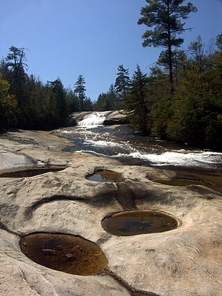
DuPont State Recreational Forest, commonly known as DuPont Forest, is a 12,500-acre (51 km2) state forest, located in Henderson and Transylvania counties of North Carolina. The name originates from the fact that the DuPont company arranged the sale of the original tract to the state. Adjacent tracts have since been purchased and added to the state forest. Portions of the forest formerly contained a manufacturing facility for the production of X-ray film. The forest was used to shoot scenes from the 1992 film The Last of the Mohicans as well as the 2012 box office hit The Hunger Games. On February 12, 2019, the forest added 402 acres (1.63 km2) from Conserving Carolina, part of a section called the Continental Divide Tract that connects with other public lands. 314 more acres was added to the forest in 2019.
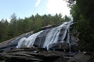
High Falls, on the Little River in Transylvania County, is a 125 ft waterfall located in the DuPont State Forest, in the Blue Ridge Mountains of North Carolina.
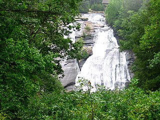
Triple Falls is a 125-foot waterfall located in the DuPont State Forest, southeast of Brevard, North Carolina.
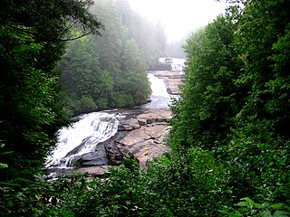
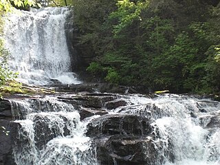
Bridal Veil Falls is a waterfall in the DuPont State Forest, on the Little River, near Brevard, North Carolina.

Dry Falls, also known as Upper Cullasaja Falls, is a 65-foot waterfall located in the Nantahala National Forest, northwest of Highlands, North Carolina.

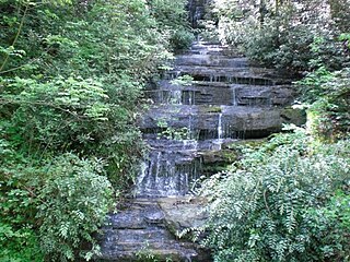
Bridal Veil Falls is a 45-foot (13.7 m) waterfall located in the Nantahala National Forest, northwest of Highlands, North Carolina. With a short curve of roadway located behind the falls, it had the distinction of being the only waterfall in the state that one could drive a vehicle under, however this has since been closed and is now used for pedestrian access only.

Bridal Veil Falls is a 365-foot waterfall at the end of the box canyon overlooking Telluride, Colorado. Hiking and off-road trails pass by the falls and it has a hydroelectric power plant at its top. In winter the frozen shape of the falls forms an imposing challenge to intrepid ice climbers.
Connestee Falls and Batson Creek Falls are two waterfalls in Western North Carolina, located near Brevard.
Key Falls, is a 50 ft waterfall located near Brevard, in the Blue Ridge Mountains of North Carolina.

The Bridal Veil Falls is six kilometres outside Sabie, Mpumalanga in South Africa. It is 70 metres high. The falls is slow flowing under normal conditions making it appear like a veil, hence its name. It is one of many waterfalls in the area that is located on the Sabie River and is a popular tourist destination. It is accessible by car, with parking and a picnic area on SAFCOL's grounds. Local curio dealers sell arts and crafts from the car park area. From the car park, a footpath runs through indigenous forest for about 750 metres directly to the waterfall.

