
Devon is a county in South West England, reaching from the Bristol Channel in the north to the English Channel in the south. It is bounded by Cornwall to the west, Somerset to the north-east and Dorset to the east. The city of Exeter is the county town. The county includes the districts of East Devon, Mid Devon, North Devon, South Hams, Teignbridge, Torridge and West Devon. Plymouth and Torbay are each geographically part of Devon, but are administered as unitary authorities. Combined as a ceremonial county, Devon's area is 6,707 km2 and its population is about 1.2 million.

Torquay is a seaside town in Devon, England, part of the unitary authority area of Torbay. It lies 18 miles (29 km) south of the county town of Exeter and 28 miles (45 km) east-north-east of Plymouth, on the north of Tor Bay, adjoining the neighbouring town of Paignton on the west of the bay and across from the fishing port of Brixham.
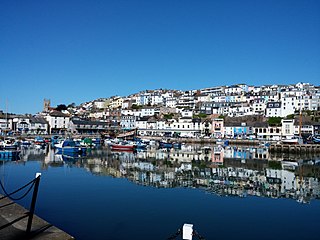
Brixham is a fishing town and civil parish in the district of Torbay in the county of Devon, in the south-west of England. Brixham is at the southern end of Torbay, across the bay from Torquay, and fishing and tourism are the major industries of the town. At the time of the 2011 census it had a population of 16,693.

Torbay is a borough and unitary authority in Devon, south west England. It is governed by Torbay Council and consists of 62.87 square kilometres (24.27 sq mi) of land, including the resort towns of Torquay, Paignton and Brixham, located on east-facing Tor Bay, part of Lyme Bay on the English Channel. A popular tourist destination, Torbay's sandy beaches, mild climate and recreational and leisure attractions have given rise to its nickname of the "English Riviera".

Paignton is a seaside town on the coast of Tor Bay in Devon, England. Together with Torquay and Brixham it forms the borough of Torbay which was created in 1998. The Torbay area is a holiday destination known as the English Riviera. Paignton's population in the United Kingdom Census of 2011 was 49,021. It has origins as a Celtic settlement and was first mentioned in 1086. It grew as a small fishing village and a new harbour was built in 1847. A railway line was opened to passengers in 1859 creating links to Torquay and London. As its population increased, it merged with the villages of Goodrington and Preston. Paignton is around 25 miles (40 km) north east of Plymouth and 20 miles (32 km) south of Exeter, and has the fourth largest population in Devon.

The South West Coast Path is England's longest waymarked long-distance footpath and a National Trail. It stretches for 630 miles (1,014 km), running from Minehead in Somerset, along the coasts of Devon and Cornwall, to Poole Harbour in Dorset. Because it rises and falls with every river mouth, it is also one of the more challenging trails. The total height climbed has been calculated to be 114,931 ft (35,031 m), almost four times the height of Mount Everest. It has been voted 'Britain's Best Walking route' twice in a row by readers of The Ramblers' Walk magazine, and regularly features in lists of the world's best walks.

The West Country is a loosely defined area of south-western England. The term usually encompasses the historic counties of Cornwall, Devon, Dorset and Somerset, and is often extended to include Wiltshire and Gloucestershire, in the South West region. Some definitions also include Herefordshire. The West Country is host to distinctive regional English dialects and accents, as well as to the Cornish language.
Ballard Down is an area of chalk downland on the Purbeck Hills in the English county of Dorset. The hills meet the English Channel here, and Ballard Down forms a headland, Ballard Point, between Studland Bay to the north and Swanage Bay to the south. The chalk here forms part of a system of chalk downlands in southern England, and once formed a continuous ridge between what is now west Dorset and the present day Isle of Wight. Old Harry Rocks, just offshore from the dip slope of the down, and The Needles on the westernmost tip of the Isle of Wight, are remnants of this ridge. The scarp slope of the down faces south, over Swanage, meeting the sea as Ballard Cliff.
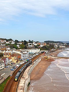
Dawlish is an English seaside resort town and civil parish in Teignbridge on the south coast of Devon, 12 miles (19 km) from the county town of Exeter and from the larger resort of Torquay. Its 2011 population of 11,312 was estimated at 13,355 in 2019. It was expected to grow further as several housing estates were under construction, mainly in the north and east of the town. It had grown in the 18th century from a small fishing port into a well-known seaside resort, as had its near neighbour, Teignmouth, in the 19th century. Between Easter and October the population can swell by an additional 20,000. largely in self-accommodation, caravan, camping and holiday parks

Thurlestone is a village 5 miles (8.0 km) west of Kingsbridge in the South Hams district in south Devon, England. There is an electoral ward in the same name. The population at the 2011 census was 1,886.

White Nothe is a chalk headland on the English Channel coast at the eastern end of Ringstead Bay, east of Weymouth in Dorset, England. The area is well known for its geology and fossils. Its flanks are the result of prehistoric landslides and the inaccessible slopes of the undercliff provide a secluded wildlife habitat.

Pontins is a British company operating holiday parks in the UK, founded in 1946 by Fred Pontin. Since 2011, it has been owned by Britannia Hotels.

The History of Torquay, a town in Torbay, on the south coast of the county of Devon, England, starts some 450,000 years ago with early human artefacts found in Kents Cavern. There is little evidence of any permanent occupation at Torquay until the eleventh century records in the Domesday Book, though it is known that visits were made by Roman soldiers and there was a small Saxon settlement called 'Torre'. In 1196 Torre Abbey was founded here, which by the time of its dissolution in 1539, had become the richest Premonstratensian Monastery in England. The buildings were bought by Sir George Cary in 1662. The Cary family and the Briwere family between them owned much of the land now occupied by Torquay. By the 19th century, most of the land was owned by three families: the Carys, the Palks, and the Mallocks.

St David's Head is a headland in the Pembrokeshire Coast National Park, southwest Wales, which marks the divide between the Irish Sea and the Celtic Sea. It is noted for its wildflowers and wildlife, and for the remains of ancient human settlement. The headland and its immediate hinterland are owned by the National Trust, and are accessible to the public by foot via the Pembrokeshire Coast Path.

Tor Bay is a bay on the south-east coast of the county of Devon, England. Facing east into the English Channel, it is about 4.5 mi (7.2 km) wide from north to south. The settlements of Torquay, Paignton and Brixham, which lie along its coastline, are known collectively as Torbay.
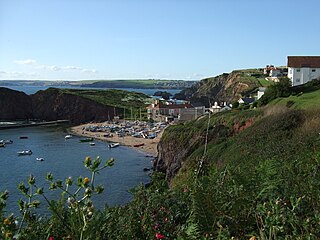
Hope Cove is a small seaside village within the civil parish of South Huish in South Hams District, Devon, England. It is located 5 miles (8.0 km) west of Salcombe and 5 miles (8.0 km) south west of Kingsbridge. It has two beaches, and is sheltered by the headland of Bolt Tail.
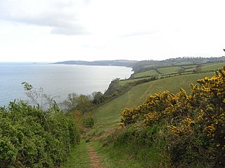
Babbacombe Bay is a South-East Devon shallow, wide, continuation of the main sweep of Lyme Bay which, in turn, to the east is the western end of the Jurassic Coast in England, UK. It faces east towards the parent, notably large bay of the English Channel, weakly sheltered from large tides from the east but much so from Atlantic tides, currents and storms from the west. As a sub-bay it covers about 4.5 miles (7.2 km). It is bounded by:
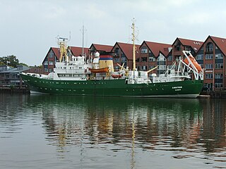
Emsstrom was a German fishery protection vessel for the Federal Ministry of Food, Agriculture and Consumer Protection built as Frithjof in 1968 at Schlichting-Werft in Travemünde.
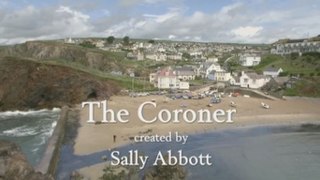
The Coroner is a BBC Birmingham drama series starring Claire Goose as Jane Kennedy, a coroner based in a fictional South Devon coastal town. Matt Bardock stars as Detective Sergeant Davey Higgins.

Long Quarry Point is a coastal promontory below Wall's Hill in Torquay, Devon, England. The site is part of the Hope's Nose to Wall's Hill Site of Special Scientific Interest.

